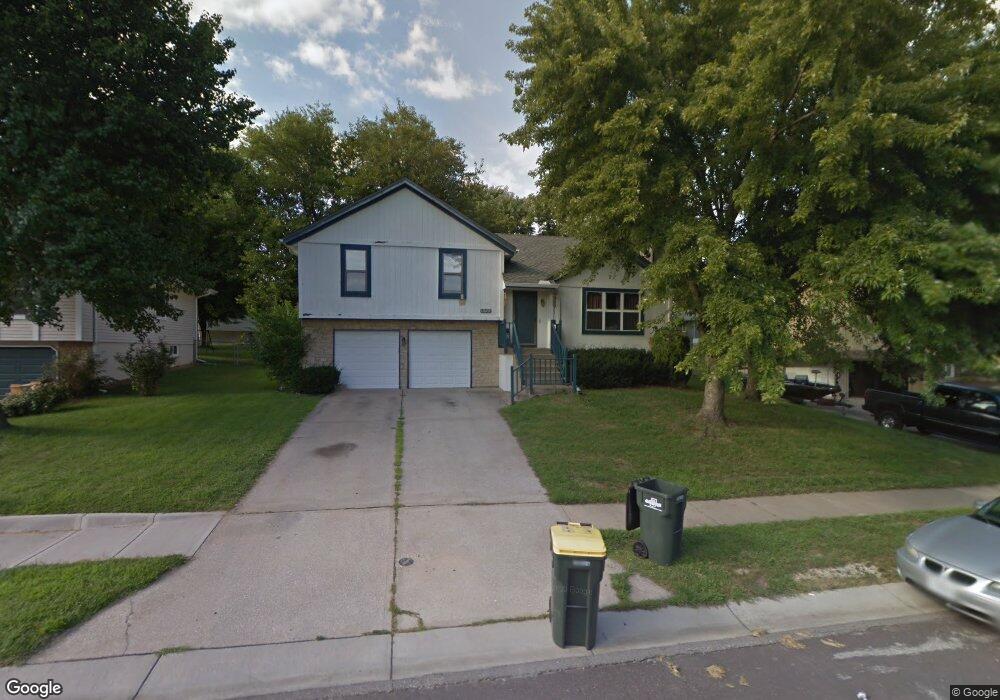
1520 NE Westwind Dr Lees Summit, MO 64086
Estimated Value: $313,710 - $334,000
About This Home
This home is located at 1520 NE Westwind Dr, Lees Summit, MO 64086 and is currently estimated at $323,428, approximately $238 per square foot. 1520 NE Westwind Dr is a home located in Jackson County with nearby schools including Underwood Elementary School, Bernard C. Campbell Middle School, and Lee's Summit North High School.
Ownership History
We collect this data history from publicly available records. To have your information removed, we recommend requesting removal directly through your county’s website.
Purchase Details
Home Financials for this Owner
Home Financials are based on the most recent Mortgage that was taken out on this home.Purchase Details
Home Values in the Area
Average Home Value in this Area
Purchase History
We collect this data history from publicly available records. To have your information removed, we recommend requesting removal directly through your county’s website.
| Date | Buyer | Sale Price | Title Company |
|---|---|---|---|
| -- | Metro One Title | ||
| -- | Stewart Title |
Mortgage History
We collect this data history from publicly available records. To have your information removed, we recommend requesting removal directly through your county’s website.
| Date | Status | Borrower | Loan Amount |
|---|---|---|---|
| Open | $130,105 |
Tax History
We collect this data history from publicly available records. To have your information removed, we recommend requesting removal directly through your county’s website.
| Year | Tax Paid | Tax Assessment Tax Assessment Total Assessment is a certain percentage of the fair market value that is determined by local assessors to be the total taxable value of land and additions on the property. | Land | Improvement |
|---|---|---|---|---|
| 2025 | $3,568 | $44,976 | $7,003 | $37,973 |
| 2024 | $3,568 | $49,417 | $7,847 | $41,570 |
| 2023 | $3,542 | $49,417 | $7,847 | $41,570 |
| 2022 | $2,745 | $34,010 | $6,897 | $27,113 |
| 2021 | $2,802 | $34,010 | $6,897 | $27,113 |
| 2020 | $2,572 | $30,916 | $6,897 | $24,019 |
| 2019 | $2,502 | $30,916 | $6,897 | $24,019 |
| 2018 | $2,480 | $28,434 | $3,881 | $24,553 |
| 2017 | $2,443 | $28,434 | $3,881 | $24,553 |
| 2016 | $2,443 | $27,721 | $3,458 | $24,263 |
| 2014 | $2,498 | $27,787 | $3,239 | $24,548 |
Map
- 1002 NE Cedar St
- 1412 NE Ernest Way
- 1416 NE Ernest Way
- 1100 NE Deerbrook Terrace
- 1210 NE Richardson Place
- 809 NE Mulberry St
- 1350 NE Colbern Rd
- 724 NE Hunters Ridge
- 1708 NE Balboa St
- 1500 NE Bronze Dr
- 1490 NE Independence Ave
- 700 NE Hunters Ridge
- 1832 NE Stonewood Dr
- 1301 NE Horizon Dr
- 1801 NE Abbey Ln
- 1108 NE Colleen Dr
- 1300 NE Browning Ln
- 1526 NE Florence Ave
- 1327 NE Depot Dr
- 410 NE Mulberry St
- 1535 NE Westwind Dr
- 1539 NE Westwind Dr
- 1531 NE Westwind Dr
- 1527 NE Westwind Dr
- 1134 NE Mulberry St
- 1601 NE Westwind Dr
- 1130 NE Mulberry St
- 1530 NE Westwind Dr
- 1523 NE Westwind Dr
- 1142 NE Mulberry St
- 1600 NE Westwind Dr
- 1124 NE Mulberry St
- 1605 NE Westwind Dr
- 1112 NE Mulberry St
- 1108 NE Mulberry St
- 1146 NE Mulberry St
- 1116 NE Mulberry St
- 1104 NE Mulberry St
- 1604 NE Westwind Dr
- 1609 NE Westwind Dr
Ask me questions while you tour the home.