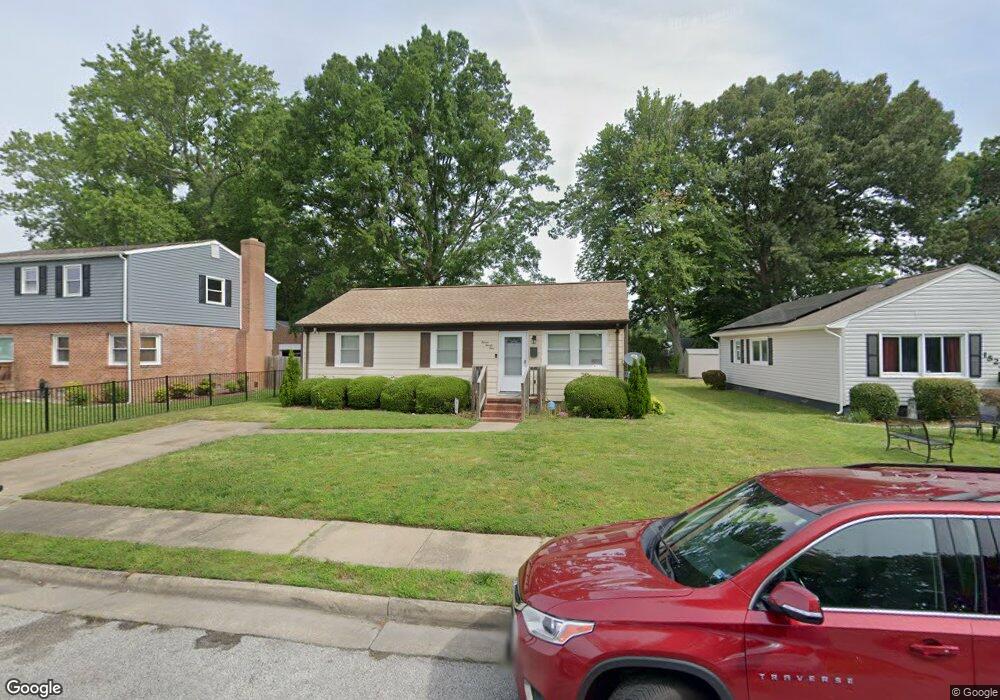
1521 Adams Cir Hampton, VA 23663
Buckroe Beach NeighborhoodEstimated Value: $229,000 - $249,000
3
Beds
1
Bath
1,279
Sq Ft
$187/Sq Ft
Est. Value
About This Home
This home is located at 1521 Adams Cir, Hampton, VA 23663 and is currently estimated at $239,760, approximately $187 per square foot. 1521 Adams Cir is a home located in Hampton City with nearby schools including Capt. John Smith Elementary School, Benjamin Syms Middle School, and Phoebus High School.
Ownership History
Date
Name
Owned For
Owner Type
Purchase Details
Closed on
Apr 27, 2006
Sold by
Jones Garnsey M
Bought by
Thomasson James E
Current Estimated Value
Home Financials for this Owner
Home Financials are based on the most recent Mortgage that was taken out on this home.
Original Mortgage
$112,700
Outstanding Balance
$65,271
Interest Rate
6.4%
Mortgage Type
New Conventional
Estimated Equity
$174,489
Create a Home Valuation Report for This Property
The Home Valuation Report is an in-depth analysis detailing your home's value as well as a comparison with similar homes in the area
Home Values in the Area
Average Home Value in this Area
Purchase History
| Date | Buyer | Sale Price | Title Company |
|---|---|---|---|
| Thomasson James E | $125,250 | -- |
Source: Public Records
Mortgage History
| Date | Status | Borrower | Loan Amount |
|---|---|---|---|
| Open | Thomasson James E | $112,700 |
Source: Public Records
Tax History Compared to Growth
Tax History
| Year | Tax Paid | Tax Assessment Tax Assessment Total Assessment is a certain percentage of the fair market value that is determined by local assessors to be the total taxable value of land and additions on the property. | Land | Improvement |
|---|---|---|---|---|
| 2025 | $2,371 | $222,000 | $57,000 | $165,000 |
| 2024 | $2,371 | $206,200 | $57,000 | $149,200 |
| 2023 | $2,014 | $173,600 | $52,500 | $121,100 |
| 2022 | $2,002 | $169,700 | $52,500 | $117,200 |
| 2021 | $1,789 | $133,800 | $42,000 | $91,800 |
| 2020 | $1,525 | $123,000 | $38,200 | $84,800 |
| 2019 | $1,525 | $123,000 | $38,200 | $84,800 |
| 2018 | $1,604 | $120,500 | $38,200 | $82,300 |
| 2017 | $1,588 | $0 | $0 | $0 |
| 2016 | $1,588 | $120,500 | $0 | $0 |
| 2015 | $1,588 | $0 | $0 | $0 |
| 2014 | $1,620 | $123,900 | $38,200 | $85,700 |
Source: Public Records
Map
Nearby Homes
- 1852 Kensington Dr
- 706 Grimes Rd
- 1427 Oakcrest Dr
- 1482 Morgan Dr
- 1428 Woodcrest Dr
- 1422 Woodcrest Dr
- 1802 Moger Dr
- 105 Ireland St
- 1926 Somerville Dr
- 1219 Hale Dr
- 438 Shelton Rd
- 440 Smiley Rd
- 1358 Coral Place
- 1304 Woodcrest Dr
- 1829 Womack Dr
- 1415 Edson Terrace
- 1340 Coral Place
- 1404 Brackin Ct
- 1400 Brackin Ct
- 2101 Andrews Blvd
- 1519 Adams Cir
- 1523 Adams Cir
- 1517 Adams Cir
- 1525 Adams Cir
- 1838 Kensington Dr
- 1836 Kensington Dr
- 1840 Kensington Dr
- 1515 Adams Cir
- 1527 Adams Cir
- 1834 Kensington Dr
- 1842 Kensington Dr
- 1522 Adams Cir
- 1520 Adams Cir
- 1524 Adams Cir
- 1518 Adams Cir
- 1513 Adams Cir
- 1844 Kensington Dr
- 1529 Adams Cir
- 701 Morris St
- 1526 Adams Cir