


1523 David Ln Waukesha, WI 53189
Estimated payment $2,558/month
Highlights
- Ranch Style House
- Fenced Yard
- Forced Air Heating System
- West High School Rated A-
- 2 Car Attached Garage
- High Speed Internet
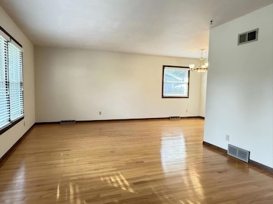
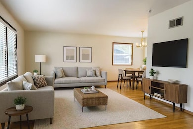
About This Home
This cozy 3-bedroom, 1.5-bathroom ranch offers the perfect balance of convenience and tranquility. Located just minutes from parks, shops, grocery stores, and restaurants, A family has grown and it is ready for another! Play set, apple tree, grape tree, perennial flowers make this fenced in yard a great place to enjoy! Many new updates and years of care makes it move in ready! The family room with an electrical fireplace leads to the patio and a vast fenced in space. The basement is semi-finished, with a flex room for a potential bedroom. Milwaukee water per seller.
Home Details
Home Type
- Single Family
Est. Annual Taxes
- $5,428
Lot Details
- 0.28 Acre Lot
- Fenced Yard
Parking
- 2 Car Attached Garage
- Garage Door Opener
- Driveway
Home Design
- Ranch Style House
- Brick Exterior Construction
Interior Spaces
- Electric Fireplace
Kitchen
- Oven
- Range
Bedrooms and Bathrooms
- 3 Bedrooms
Laundry
- Dryer
- Washer
Partially Finished Basement
- Basement Fills Entire Space Under The House
- Block Basement Construction
- Crawl Space
Schools
- Prairie Elementary School
- LES Paul Middle School
- Waukesha West High School
Utilities
- Forced Air Heating System
- Heating System Uses Natural Gas
- High Speed Internet
Community Details
- Fox Point Village Subdivision
Listing and Financial Details
- Assessor Parcel Number 2911358046
Map
Home Values in the Area
Average Home Value in this Area
Tax History
| Year | Tax Paid | Tax Assessment Tax Assessment Total Assessment is a certain percentage of the fair market value that is determined by local assessors to be the total taxable value of land and additions on the property. | Land | Improvement |
|---|---|---|---|---|
| 2024 | $5,428 | $364,600 | $78,200 | $286,400 |
| 2023 | $5,282 | $364,600 | $78,200 | $286,400 |
| 2022 | $4,597 | $239,900 | $67,700 | $172,200 |
| 2021 | $4,705 | $239,900 | $67,700 | $172,200 |
| 2020 | $4,546 | $239,900 | $67,700 | $172,200 |
| 2019 | $4,405 | $239,900 | $67,700 | $172,200 |
| 2018 | $4,201 | $224,200 | $58,300 | $165,900 |
| 2017 | $4,189 | $224,200 | $58,300 | $165,900 |
| 2016 | $3,979 | $200,200 | $52,700 | $147,500 |
| 2015 | $3,955 | $200,200 | $52,700 | $147,500 |
| 2014 | $3,961 | $192,500 | $52,700 | $139,800 |
| 2013 | $3,961 | $192,500 | $52,700 | $139,800 |
Property History
| Date | Event | Price | List to Sale | Price per Sq Ft |
|---|---|---|---|---|
| 09/11/2025 09/11/25 | For Sale | $399,900 | -- | $199 / Sq Ft |
Purchase History
| Date | Type | Sale Price | Title Company |
|---|---|---|---|
| Personal Reps Deed | $117,800 | -- |
Mortgage History
| Date | Status | Loan Amount | Loan Type |
|---|---|---|---|
| Previous Owner | $88,300 | No Value Available |
Source: Metro MLS
MLS Number: 1934684
APN: WAKC-1358-046
Disclaimer: Certain information contained herein is derived from information provided by parties other than Homes.com. All information provided is deemed reliable, but is not guaranteed to be accurate and should be independently verified.
![]() IDX information is provided exclusively for personal, non-commercial use, and may not be used for any purpose other than to identify prospective properties consumers may be interested in purchasing.
IDX information is provided exclusively for personal, non-commercial use, and may not be used for any purpose other than to identify prospective properties consumers may be interested in purchasing.
IDX listing data provided by Multiple Listing Service, Inc. Information is supplied by seller and other third parties and has not been verified.
Copyright 2025 – Multiple Listing Service, Inc. – All Rights Reserved.
- 1621 Fox River Pkwy
- S31W26111 Sunset Dr
- 1705 Chapman Dr
- 1887 Haymarket Rd Unit 31
- 1891 Haymarket Rd Unit 33
- 1804 Hemit Ave
- 1005 Burr Oak Blvd
- 1210 Woodbury Common Unit C
- 1203 Woodbury Common Unit B
- 1203 Woodbury Common Unit D
- 1050 S Grandview Blvd
- 1030 River Place Blvd Unit 4
- 2741 Brighton Dr
- 1027 River Place Blvd Unit 1027
- 2734 Field Dr
- 901 Canterbury Ln
- 2708 Fox Hill Dr
- S54W25436 Pebble Brook Ct
- S54W25487 Pebble Brook Ct
- Lt6 Finch Ct
- 2302 W Saint Paul Ave
- 2000 Oakdale Dr
- 1149 Burr Oak Blvd
- S30w24890-W24890 Sunset Dr
- 2601 Elkhart Dr
- 1008 River Place Blvd
- 2105 Kensington Dr
- 1800 Kensington Dr
- 326 Born Place Unit 326
- 1212 S Grand Ave
- 120 Cambridge Ave
- 405 S Hine Ave
- 209 Hinman Ave
- 806 Riverwalk Dr
- 201 Maple Ave
- 2051 Cliff Alex Ct S Unit 3
- 2 S Grand Ave
- 305 Maple Ave
- 207 N Moreland Blvd
- 2950 Clearwater Ln
