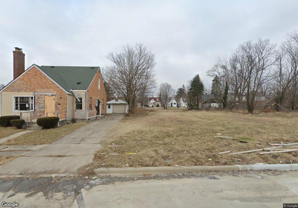
15235 Linnhurst St Detroit, MI 48205
Maple Ridge NeighborhoodEstimated Value: $74,000 - $90,000
--
Bed
1
Bath
853
Sq Ft
$99/Sq Ft
Est. Value
About This Home
This home is located at 15235 Linnhurst St, Detroit, MI 48205 and is currently estimated at $84,345, approximately $98 per square foot. 15235 Linnhurst St is a home located in Wayne County with nearby schools including Edward 'Duke' Ellington Conservatory of Music and Art, Charles L. Spain Elementary-Middle School, and Denby High School.
Ownership History
Date
Name
Owned For
Owner Type
Purchase Details
Closed on
May 9, 2014
Sold by
The State Of Michigan
Bought by
Detroit Land Bank Authority
Current Estimated Value
Purchase Details
Closed on
Oct 5, 2012
Sold by
Wayne County Treasurer
Bought by
Michigan Land Bank Fast Track Auth
Purchase Details
Closed on
Feb 14, 2008
Sold by
Mortgage Electronic Registration Systems
Bought by
Countrywide Home Loans Inc
Purchase Details
Closed on
Dec 27, 2007
Sold by
Mortgage Electronic Registration Systems
Bought by
Countrywide Home Loans Inc
Purchase Details
Closed on
Sep 20, 2006
Sold by
Owens Anthony
Bought by
Mortgage Electronic Registration Systems
Purchase Details
Closed on
Mar 30, 2006
Sold by
Fuga Mark A and Fuga Deborah
Bought by
Owens Anthony
Create a Home Valuation Report for This Property
The Home Valuation Report is an in-depth analysis detailing your home's value as well as a comparison with similar homes in the area
Home Values in the Area
Average Home Value in this Area
Purchase History
| Date | Buyer | Sale Price | Title Company |
|---|---|---|---|
| Detroit Land Bank Authority | -- | None Available | |
| Michigan Land Bank Fast Track Auth | -- | None Available | |
| Countrywide Home Loans Inc | -- | Metropolitan Title Company | |
| Countrywide Home Loans Inc | -- | E Title Agency | |
| Mortgage Electronic Registration Systems | $61,199 | None Available | |
| Owens Anthony | $67,000 | Multiple |
Source: Public Records
Tax History Compared to Growth
Tax History
| Year | Tax Paid | Tax Assessment Tax Assessment Total Assessment is a certain percentage of the fair market value that is determined by local assessors to be the total taxable value of land and additions on the property. | Land | Improvement |
|---|---|---|---|---|
| 2025 | -- | $0 | $0 | $0 |
| 2024 | -- | $0 | $0 | $0 |
| 2023 | $0 | $0 | $0 | $0 |
| 2022 | $0 | $0 | $0 | $0 |
| 2021 | $0 | $0 | $0 | $0 |
| 2020 | $1,826 | $0 | $0 | $0 |
| 2019 | $1,826 | $0 | $0 | $0 |
| 2018 | $0 | $0 | $0 | $0 |
| 2017 | -- | $0 | $0 | $0 |
| 2016 | $1,620 | $0 | $0 | $0 |
| 2015 | $1,620 | $0 | $0 | $0 |
| 2013 | $1,620 | $16,195 | $0 | $0 |
| 2010 | -- | $23,744 | $998 | $22,746 |
Source: Public Records
Map
Nearby Homes
- 15227 Linnhurst St
- 15257 Faircrest St
- 15294 Saratoga St
- 15315 Park Grove St
- 15309 Mapleridge St
- 15480 Saratoga St
- 15243 Fordham St
- 15430 Mapleridge St
- 14895 Mapleridge St
- 14253 Fordham St
- 18814 Morang Dr
- 18820 Morang Dr
- 14881 Mapleridge St
- 15470 Mapleridge St
- 15646 Saratoga St
- 15611 Mapleridge St
- 15596 Eastwood St
- 15241 Seymour St
- 14916 Maddelein St
- 15276 Seymour St
- 15245 Linnhurst St
- 15251 Linnhurst St
- 15219 Linnhurst St
- 15261 Linnhurst St
- 15232 Faircrest St
- 15244 Faircrest St
- 15226 Faircrest St
- 15250 Faircrest St
- 15271 Linnhurst St
- 15238 Linnhurst St
- 15232 Linnhurst St
- 15246 Linnhurst St
- 15220 Linnhurst St
- 15260 Faircrest St
- 15256 Linnhurst St
- 15216 Linnhurst St
- 15279 Linnhurst St
- 15264 Linnhurst St
- 15266 Linnhurst St
- 15270 Faircrest St