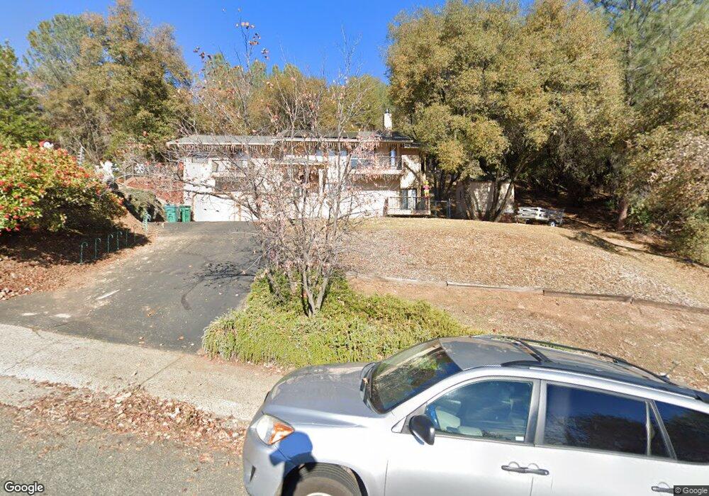
1525 Sean Dr Placerville, CA 95667
Estimated Value: $617,647 - $703,000
4
Beds
3
Baths
2,404
Sq Ft
$270/Sq Ft
Est. Value
About This Home
This home is located at 1525 Sean Dr, Placerville, CA 95667 and is currently estimated at $649,662, approximately $270 per square foot. 1525 Sean Dr is a home located in El Dorado County with nearby schools including El Dorado High School, Country Day Montessori, and El Dorado Adventist School.
Ownership History
Date
Name
Owned For
Owner Type
Purchase Details
Closed on
Sep 7, 2011
Sold by
Neau Steven L and Neau Jacqueline A
Bought by
Neau Steven Leslie and Neau Jacqueline Ann
Current Estimated Value
Purchase Details
Closed on
May 10, 1999
Sold by
Mcintosh Paul E and Hegedus Susan M
Bought by
Neau Steven L and Neau Jacqueline A
Home Financials for this Owner
Home Financials are based on the most recent Mortgage that was taken out on this home.
Original Mortgage
$190,800
Outstanding Balance
$48,891
Interest Rate
6.94%
Estimated Equity
$600,771
Create a Home Valuation Report for This Property
The Home Valuation Report is an in-depth analysis detailing your home's value as well as a comparison with similar homes in the area
Home Values in the Area
Average Home Value in this Area
Purchase History
| Date | Buyer | Sale Price | Title Company |
|---|---|---|---|
| Neau Steven Leslie | -- | None Available | |
| Neau Steven L | $212,000 | Chicago Title Co |
Source: Public Records
Mortgage History
| Date | Status | Borrower | Loan Amount |
|---|---|---|---|
| Open | Neau Steven L | $190,800 |
Source: Public Records
Tax History
| Year | Tax Paid | Tax Assessment Tax Assessment Total Assessment is a certain percentage of the fair market value that is determined by local assessors to be the total taxable value of land and additions on the property. | Land | Improvement |
|---|---|---|---|---|
| 2025 | $3,378 | $332,317 | $89,337 | $242,980 |
| 2024 | $3,378 | $325,802 | $87,586 | $238,216 |
| 2023 | $3,338 | $319,415 | $85,869 | $233,546 |
| 2022 | $3,289 | $313,153 | $84,186 | $228,967 |
| 2021 | $3,251 | $307,014 | $82,536 | $224,478 |
| 2020 | $3,202 | $303,867 | $81,690 | $222,177 |
| 2019 | $3,161 | $297,910 | $80,089 | $217,821 |
| 2018 | $3,065 | $292,069 | $78,519 | $213,550 |
| 2017 | $3,018 | $286,343 | $76,980 | $209,363 |
| 2016 | $2,970 | $280,729 | $75,471 | $205,258 |
| 2015 | $2,833 | $276,515 | $74,339 | $202,176 |
| 2014 | $2,833 | $271,101 | $72,884 | $198,217 |
Source: Public Records
Map
Nearby Homes
- 1531 Jeffrey Ln
- 3550 Eskaton Dr
- 1302 Nicks Ln
- 1764 Country Club Dr
- 1030 Lemongrass Ct
- 3930 Cedar Ravine Rd
- 1720 Jacobs Way
- 2500 N View Ln
- 3237 Francis Ave
- 3166 Cedar Ravine Rd
- 2977 Mosquito Rd
- 678 Main St
- 3095 Cedar Ravine Rd
- 949 Bliss Ct
- 3353 Airport Rd
- 2660 Clay St
- 3113 Clark St
- 899 Estey Way
- 3254 Clark St
- 3124 Clark St
Your Personal Tour Guide
Ask me questions while you tour the home.