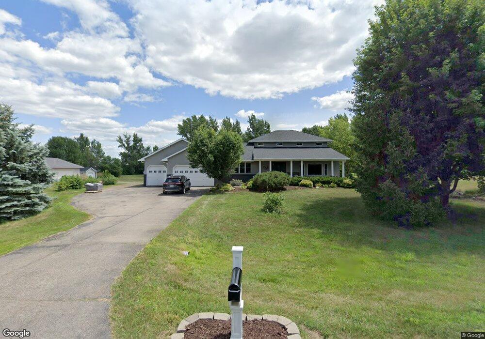
1526 Mark Ct Shakopee, MN 55379
Estimated Value: $745,000 - $855,000
4
Beds
3
Baths
2,812
Sq Ft
$280/Sq Ft
Est. Value
About This Home
This home is located at 1526 Mark Ct, Shakopee, MN 55379 and is currently estimated at $788,514, approximately $280 per square foot. 1526 Mark Ct is a home located in Scott County with nearby schools including Sweeney Elementary School, East Middle School, and Shakopee Senior High School.
Ownership History
Date
Name
Owned For
Owner Type
Purchase Details
Closed on
Aug 17, 2017
Sold by
Olson Scott C and Olson Stacy A
Bought by
Meyer Corey D and Meyer Elisabeth T
Current Estimated Value
Home Financials for this Owner
Home Financials are based on the most recent Mortgage that was taken out on this home.
Original Mortgage
$387,900
Outstanding Balance
$324,282
Interest Rate
4.03%
Mortgage Type
New Conventional
Estimated Equity
$464,232
Purchase Details
Closed on
Jun 28, 2007
Sold by
Vanderleest Jay M and Vanderleest Kelly A
Bought by
Olson Scott C and Olson Stacy A
Purchase Details
Closed on
Jun 25, 2004
Sold by
Hobart Barry R and Hobart Kimberly C
Bought by
Vanderleest Jay M and Vanderleest Kelly A
Purchase Details
Closed on
Apr 27, 1998
Sold by
Weinandt Harris L
Bought by
Hobart Barry R
Create a Home Valuation Report for This Property
The Home Valuation Report is an in-depth analysis detailing your home's value as well as a comparison with similar homes in the area
Home Values in the Area
Average Home Value in this Area
Purchase History
| Date | Buyer | Sale Price | Title Company |
|---|---|---|---|
| Meyer Corey D | $484,900 | Scott County Abstract And Ti | |
| Olson Scott C | $441,900 | -- | |
| Vanderleest Jay M | $393,900 | -- | |
| Hobart Barry R | $44,900 | -- |
Source: Public Records
Mortgage History
| Date | Status | Borrower | Loan Amount |
|---|---|---|---|
| Open | Meyer Corey D | $387,900 |
Source: Public Records
Tax History Compared to Growth
Tax History
| Year | Tax Paid | Tax Assessment Tax Assessment Total Assessment is a certain percentage of the fair market value that is determined by local assessors to be the total taxable value of land and additions on the property. | Land | Improvement |
|---|---|---|---|---|
| 2025 | $7,754 | $715,900 | $219,300 | $496,600 |
| 2024 | $7,882 | $696,000 | $219,300 | $476,700 |
| 2023 | $7,804 | $697,000 | $216,800 | $480,200 |
| 2022 | $7,274 | $679,200 | $206,500 | $472,700 |
| 2021 | $5,544 | $559,500 | $168,200 | $391,300 |
| 2020 | $6,446 | $474,100 | $148,200 | $325,900 |
| 2019 | $6,646 | $483,000 | $155,300 | $327,700 |
| 2018 | $5,082 | $0 | $0 | $0 |
| 2016 | $5,650 | $0 | $0 | $0 |
| 2014 | -- | $0 | $0 | $0 |
Source: Public Records
Map
Nearby Homes
- 981 Peninsula Point Rd
- 2657 Aspen Dr
- 2624 Lakeview Dr
- 1017 Vista Ridge Ln
- 746 Peninsula Point Rd
- 14020 Townline Ave
- 2425 Peace Cir
- 2390 Jennifer Ln
- 1XX Stonebrooke Curve
- 3XX Stonebrooke Curve
- 13599 Stonebrooke Curve
- 13864 Stonebrooke Curve
- 1363 Ridge Ln
- 1353 Ridge Ln
- 13400 Townline Ave
- 2740 Aspen Dr
- 2689 Aspen Dr
- 2043 Eaglewood Dr
- 2353 Rock Elm Rd
- 2340 Rock Elm Rd