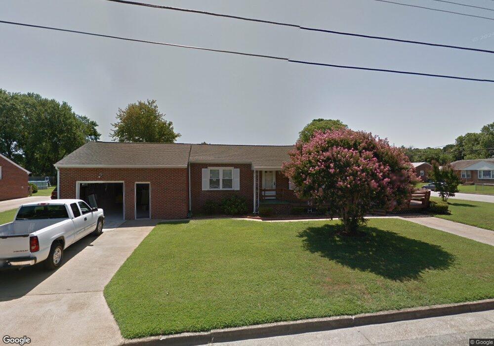
1528 Denton Dr Hampton, VA 23664
Estimated Value: $242,000 - $281,626
3
Beds
1
Bath
1,134
Sq Ft
$234/Sq Ft
Est. Value
About This Home
This home is located at 1528 Denton Dr, Hampton, VA 23664 and is currently estimated at $264,907, approximately $233 per square foot. 1528 Denton Dr is a home located in Hampton City with nearby schools including Jane H. Bryan Elementary School, Benjamin Syms Middle School, and Phoebus High School.
Ownership History
Date
Name
Owned For
Owner Type
Purchase Details
Closed on
Apr 23, 2024
Sold by
Daniel Donna Sue
Bought by
Daniel David W
Current Estimated Value
Home Financials for this Owner
Home Financials are based on the most recent Mortgage that was taken out on this home.
Original Mortgage
$176,129
Interest Rate
6.89%
Mortgage Type
New Conventional
Purchase Details
Closed on
Jul 23, 2015
Sold by
Jenkins Charles E
Bought by
Old Point Trust And Financial
Create a Home Valuation Report for This Property
The Home Valuation Report is an in-depth analysis detailing your home's value as well as a comparison with similar homes in the area
Purchase History
| Date | Buyer | Sale Price | Title Company |
|---|---|---|---|
| Daniel David W | -- | None Listed On Document | |
| Old Point Trust And Financial | $134,000 | -- |
Source: Public Records
Mortgage History
| Date | Status | Borrower | Loan Amount |
|---|---|---|---|
| Previous Owner | Daniel David W | $176,129 |
Source: Public Records
Tax History
| Year | Tax Paid | Tax Assessment Tax Assessment Total Assessment is a certain percentage of the fair market value that is determined by local assessors to be the total taxable value of land and additions on the property. | Land | Improvement |
|---|---|---|---|---|
| 2025 | $2,898 | $259,400 | $60,000 | $199,400 |
| 2024 | $2,544 | $221,200 | $60,000 | $161,200 |
| 2023 | $2,349 | $202,500 | $55,000 | $147,500 |
| 2022 | $2,340 | $198,300 | $45,000 | $153,300 |
| 2021 | $2,243 | $170,400 | $40,000 | $130,400 |
| 2020 | $1,928 | $155,500 | $36,400 | $119,100 |
| 2019 | $1,928 | $155,500 | $36,400 | $119,100 |
| 2018 | $1,896 | $150,900 | $36,400 | $114,500 |
| 2017 | $1,965 | $0 | $0 | $0 |
| 2016 | $1,965 | $150,900 | $0 | $0 |
| 2015 | $1,769 | $0 | $0 | $0 |
| 2014 | $1,837 | $141,400 | $36,400 | $105,000 |
Source: Public Records
Map
Nearby Homes
- 1642 N Mallory St
- 17 Seaview Dr
- 5B Mallory
- 9 Bayview Ct
- 532 Slater Ave
- 155 Atlantic Ave
- 155 Atlantic Ave Unit C2
- 1527 Grove St
- 714 Grove St
- 2112 E Pembroke Ave
- 604 Old Buckroe Rd
- 733 Burgess Ave
- 731 Burgess Ave
- 2013 Whitman Place
- 1333 N Mallory St
- 438 Shelton Rd
- 1928 Long Green Ln
- 6 Langille Ct
- 27 E Berkley Dr
- 1915 Long Green Ln
- 8 Whitaker Ave
- 1530 Denton Dr
- 1529 Denton Dr
- 6 Whitaker Ave
- 15 Mansford Dr
- 1532 Denton Dr
- 1524 Denton Dr
- 7 Whitaker Ave
- 4 Whitaker Ave
- 16 Whitaker Ave
- 15 Whitaker Ave
- 5 Whitaker Ave
- 1534 Denton Dr
- 17 Mansford Dr
- 1531 N Mallory St
- 3 Whitaker Ave
- 1529 N Mallory St
- 1523 Denton Dr
- 18 Whitaker Ave
- 1522 Denton Dr
Your Personal Tour Guide
Ask me questions while you tour the home.