Estimated Value: $557,383 - $641,000
3
Beds
3
Baths
2,008
Sq Ft
$299/Sq Ft
Est. Value
About This Home
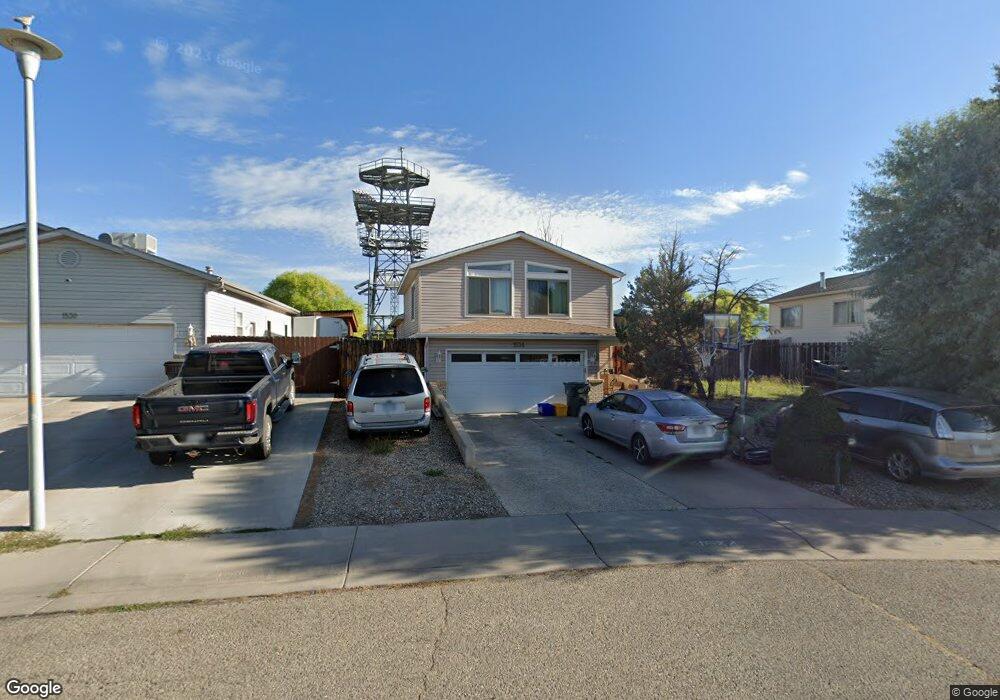
This home is located at 1534 E 12th St, Rifle, CO 81650 and is currently estimated at $601,346, approximately $299 per square foot. 1534 E 12th St is a home located in Garfield County with nearby schools including Highland Elementary School, Rifle Middle School, and Rifle High School.
Ownership History
Date
Name
Owned For
Owner Type
Purchase Details
Closed on
Dec 9, 2024
Sold by
Rapids Development Corporation
Bought by
Perez Moises and Perez Kenia Rebecca
Current Estimated Value
Purchase Details
Closed on
Jul 13, 2005
Sold by
Cardenas Sergio and Cardenas Carmen
Bought by
Cardenas Sergio Arturo
Home Financials for this Owner
Home Financials are based on the most recent Mortgage that was taken out on this home.
Original Mortgage
$223,250
Interest Rate
5.99%
Mortgage Type
New Conventional
Purchase Details
Closed on
Feb 27, 1997
Create a Home Valuation Report for This Property
The Home Valuation Report is an in-depth analysis detailing your home's value as well as a comparison with similar homes in the area
Home Values in the Area
Average Home Value in this Area
Purchase History
| Date | Buyer | Sale Price | Title Company |
|---|---|---|---|
| Perez Moises | $229,000 | Land Title | |
| Cardenas Sergio Arturo | -- | Nations Title Agency | |
| -- | $154,000 | -- | |
| -- | $154,000 | -- |
Source: Public Records
Mortgage History
| Date | Status | Borrower | Loan Amount |
|---|---|---|---|
| Previous Owner | Cardenas Sergio Arturo | $223,250 |
Source: Public Records
Tax History
| Year | Tax Paid | Tax Assessment Tax Assessment Total Assessment is a certain percentage of the fair market value that is determined by local assessors to be the total taxable value of land and additions on the property. | Land | Improvement |
|---|---|---|---|---|
| 2025 | $2,710 | $30,830 | $4,060 | $26,770 |
| 2024 | $2,710 | $25,460 | $2,520 | $22,940 |
| 2023 | $1,941 | $25,460 | $2,520 | $22,940 |
| 2022 | $1,482 | $20,700 | $2,360 | $18,340 |
| 2021 | $1,702 | $21,290 | $2,430 | $18,860 |
| 2020 | $1,650 | $22,560 | $2,220 | $20,340 |
| 2019 | $1,562 | $22,560 | $2,220 | $20,340 |
| 2018 | $1,321 | $18,660 | $2,300 | $16,360 |
| 2017 | $1,194 | $18,660 | $2,300 | $16,360 |
| 2016 | $1,027 | $18,170 | $2,390 | $15,780 |
| 2015 | $948 | $18,170 | $2,390 | $15,780 |
| 2014 | -- | $13,810 | $1,950 | $11,860 |
Source: Public Records
Map
Nearby Homes
- 1558 E 12th St
- 1357 W Spruce Ct
- 902 Hickory Dr
- 1433 Jays Ave
- 949 Edelweiss Ct
- 1226 E 17th St
- 1310 Dogwood Dr
- 1671 E 17th Cir
- 1173 E 18th Way
- 1546 Arabian Ave
- 1631 Walnut Loop
- 837 E 17th St Unit A
- 751 Buckeye Ct
- 1667 Balsam Loop
- 1395 Rifle Heights Dr
- 660 Aspen Ave
- Phase 2 Rifle Creek
- 600 Mccarron Ct Unit A
- 600 Mccarron Ct Unit B
- 600 Mc Carron Court Unit: Unit B
- 1530 E 12th St
- 1538 E 12th St
- 1542 E 12th St
- 1526 E 12th St
- 1398 Firethorn Dr
- 1537 E 12th St
- 1545 E 12th St
- 1118 Firethorn Ct
- 1394 Firethorn Dr
- 1549 E 12th St
- 1116 Hickory Dr
- 0 Hickory Dr
- 1520 E 12th St
- 1392 Firethorn Dr
- 1110 Firethorn Ct
- 1397 Firethorn Dr
- 1423 E Spruce Ct
- 1117 Firethorn Ct
- 1550 E 12th St
- 1117 Firethorn Ct
Your Personal Tour Guide
Ask me questions while you tour the home.