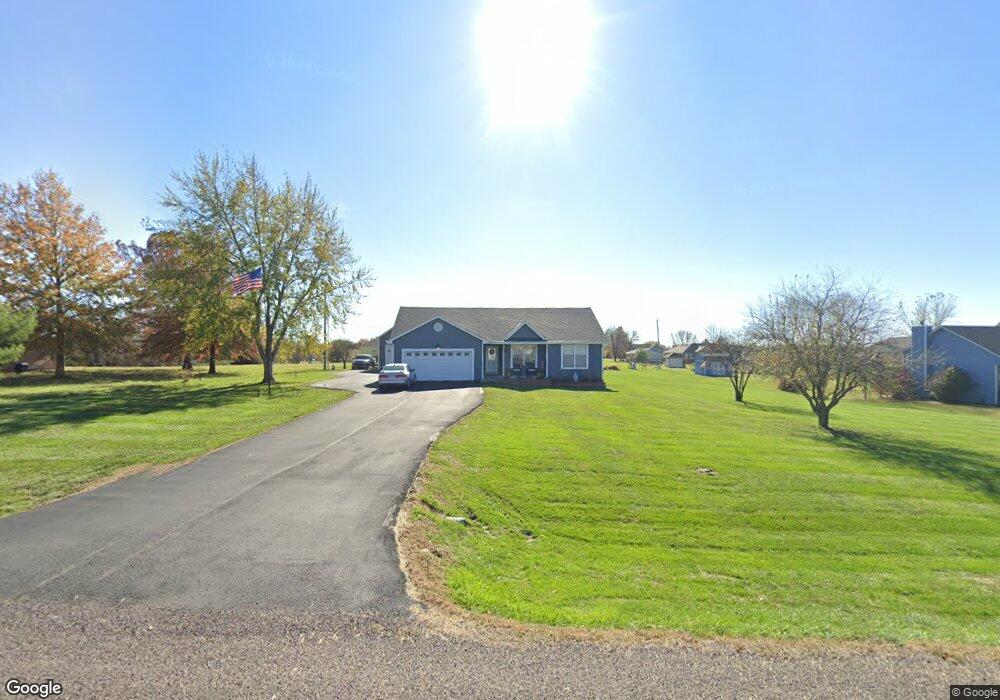
15431 Roger Rd Leavenworth, KS 66048
Estimated Value: $405,000 - $428,000
3
Beds
2
Baths
1,315
Sq Ft
$320/Sq Ft
Est. Value
About This Home
This home is located at 15431 Roger Rd, Leavenworth, KS 66048 and is currently estimated at $420,715, approximately $319 per square foot. 15431 Roger Rd is a home located in Leavenworth County with nearby schools including Lansing Elementary School, Lansing Middle 6-8, and Lansing High 9-12.
Ownership History
Date
Name
Owned For
Owner Type
Purchase Details
Closed on
Aug 28, 2019
Sold by
Stephenson Family Legacy Trust
Bought by
Fladung Scott A and Fladung Victoria C
Current Estimated Value
Home Financials for this Owner
Home Financials are based on the most recent Mortgage that was taken out on this home.
Original Mortgage
$189,525
Outstanding Balance
$166,684
Interest Rate
3.8%
Mortgage Type
New Conventional
Estimated Equity
$254,031
Purchase Details
Closed on
Oct 3, 2018
Sold by
Stephenson Catherine M
Bought by
Stephenson Family Legacy Trust
Purchase Details
Closed on
May 1, 1996
Bought by
Stephenson Earl L and Stephenson Catherine M
Create a Home Valuation Report for This Property
The Home Valuation Report is an in-depth analysis detailing your home's value as well as a comparison with similar homes in the area
Home Values in the Area
Average Home Value in this Area
Purchase History
| Date | Buyer | Sale Price | Title Company |
|---|---|---|---|
| Fladung Scott A | $252,068 | None Listed On Document | |
| Stephenson Family Legacy Trust | -- | None Listed On Document | |
| Stephenson Earl L | $116,915 | -- |
Source: Public Records
Mortgage History
| Date | Status | Borrower | Loan Amount |
|---|---|---|---|
| Open | Fladung Scott A | $189,525 |
Source: Public Records
Tax History Compared to Growth
Tax History
| Year | Tax Paid | Tax Assessment Tax Assessment Total Assessment is a certain percentage of the fair market value that is determined by local assessors to be the total taxable value of land and additions on the property. | Land | Improvement |
|---|---|---|---|---|
| 2025 | $4,743 | $44,533 | $6,830 | $37,703 |
| 2024 | $4,405 | $42,820 | $6,401 | $36,419 |
| 2023 | $4,405 | $41,573 | $6,401 | $35,172 |
| 2022 | $3,968 | $36,134 | $5,486 | $30,648 |
| 2021 | $2,765 | $25,055 | $4,600 | $20,455 |
| 2020 | $2,572 | $22,943 | $4,428 | $18,515 |
| 2019 | $2,563 | $23,012 | $4,083 | $18,929 |
| 2018 | $2,271 | $20,456 | $3,163 | $17,293 |
| 2017 | $2,146 | $19,297 | $2,961 | $16,336 |
| 2016 | $2,066 | $18,683 | $2,933 | $15,750 |
| 2015 | -- | $17,792 | $2,933 | $14,859 |
| 2014 | -- | $17,274 | $2,933 | $14,341 |
Source: Public Records
Map
Nearby Homes
- 15280 Roger Rd
- 15038 Fairmount Rd
- 14934 Fairmount Rd
- 22617 155th St
- 23802 140th St
- 14165 Ashbury Ct
- Lot 2 139th St
- 6508 141st St
- 5025 146th St
- 5023 146th St
- 5005 146th St
- 5020 146th St
- 5018 146th St
- 833 Rock Creek Dr
- 5001 N 145th St
- 4551 N 145th St
- 13965 Mc Intyre Rd
- 705 Rock Creek Dr
- 1221 S Desoto Rd
- 00000 Gilman Rd
- 15447 Roger Rd
- 15415 Roger Rd
- 15424 Roger Rd
- 15456 Brandt Rd
- 15446 Roger Rd
- 15424 Brandt Rd
- 15478 Brandt Rd
- 15468 Roger Rd
- 15495 Roger Rd
- 15251 Roger Rd
- 15478 Roger Rd
- 15494 Brandt Rd
- 15380 Roger Rd
- 15351 Roger Rd
- 15354 Brandt Rd
- 15350 Roger Rd
- 15439 Brandt Rd
- 15477 Brandt Rd
- 15441 Brandt Rd
- 15451 Brandt Rd