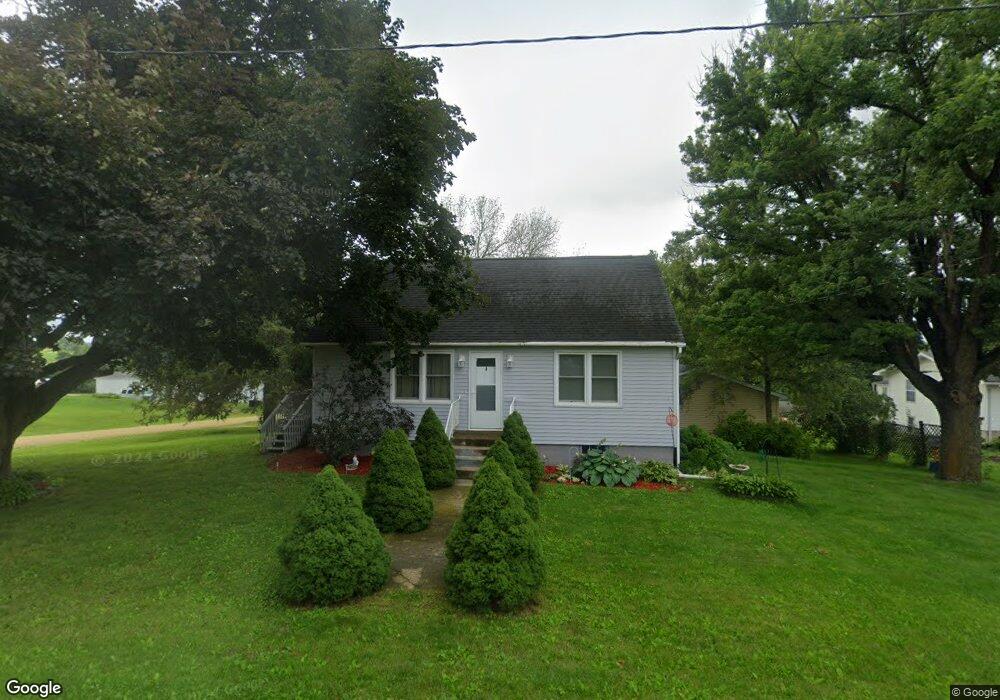
15463 Bluecut Rd Anamosa, IA 52205
Estimated Value: $159,603 - $195,000
3
Beds
2
Baths
1,210
Sq Ft
$147/Sq Ft
Est. Value
About This Home
This home is located at 15463 Bluecut Rd, Anamosa, IA 52205 and is currently estimated at $177,651, approximately $146 per square foot. 15463 Bluecut Rd is a home located in Jones County with nearby schools including Strawberry Hill Elementary School, Anamosa Middle School, and Anamosa High School.
Ownership History
Date
Name
Owned For
Owner Type
Purchase Details
Closed on
May 19, 2011
Sold by
Hunts Reality Inc
Bought by
Keller Robert J
Current Estimated Value
Purchase Details
Closed on
Jun 11, 2009
Sold by
Bright Cody M and Bright Holly J
Bought by
Keller Robert J
Home Financials for this Owner
Home Financials are based on the most recent Mortgage that was taken out on this home.
Original Mortgage
$77,040
Interest Rate
4.92%
Mortgage Type
New Conventional
Create a Home Valuation Report for This Property
The Home Valuation Report is an in-depth analysis detailing your home's value as well as a comparison with similar homes in the area
Home Values in the Area
Average Home Value in this Area
Purchase History
| Date | Buyer | Sale Price | Title Company |
|---|---|---|---|
| Keller Robert J | $4,500 | None Available | |
| Keller Robert J | $78,500 | Jones Co Abstract |
Source: Public Records
Mortgage History
| Date | Status | Borrower | Loan Amount |
|---|---|---|---|
| Previous Owner | Keller Robert J | $77,040 |
Source: Public Records
Tax History Compared to Growth
Tax History
| Year | Tax Paid | Tax Assessment Tax Assessment Total Assessment is a certain percentage of the fair market value that is determined by local assessors to be the total taxable value of land and additions on the property. | Land | Improvement |
|---|---|---|---|---|
| 2025 | $1,566 | $141,840 | $10,170 | $131,670 |
| 2024 | $1,566 | $131,710 | $10,170 | $121,540 |
| 2023 | $1,526 | $131,710 | $10,170 | $121,540 |
| 2022 | $1,314 | $100,610 | $10,170 | $90,440 |
| 2021 | $1,314 | $100,610 | $10,170 | $90,440 |
| 2020 | $1,168 | $87,690 | $10,170 | $77,520 |
| 2019 | $1,148 | $87,690 | $10,170 | $77,520 |
| 2018 | $1,084 | $83,540 | $4,300 | $79,240 |
| 2017 | $1,084 | $83,540 | $4,300 | $79,240 |
| 2016 | $1,008 | $78,590 | $4,300 | $74,290 |
| 2015 | $1,008 | $78,590 | $4,300 | $74,290 |
| 2014 | $1,002 | $75,500 | $4,300 | $71,200 |
| 2013 | $960 | $75,500 | $4,300 | $71,200 |
Source: Public Records
Map
Nearby Homes
- 435 Council St
- 108 Wood Ridge Rd
- 433 Council St
- 128 Woodridge Rd
- 1611 Breca Ridge Dr Unit 4
- 1606 Breca Ridge Dr
- 149 Country Club Ct
- 1007 Maquoketa St
- 103 N Oak St
- 1108 E 3rd St
- 420 Knoll St
- 508 Rosemary Ln
- 227th Ave and E-34
- 501 N Division St
- 105 N Division St
- 304 E Plum St
- 302 N Pratt St
- 408 Holt St
- 207 N Davis St
- 114 Therese Ave
- 13474 Amber Road X44
- 13496 Amber Road X44
- 13478 Amber Road X44
- 13478 Amber Road X44
- 13494 Ramsey Rd
- 13508 Ramsey Rd
- 13535 Ramsey Rd
- 13588 Amber Road X44
- 13482 Ramsey Rd
- 13532 Ramsey Rd
- 13546 Ramsey Rd
- 13473 Amber Road X44
- 13547 Ramsey Rd
- 15516 Bluecut Rd
- 13487 Amber Road X44
- 13434 Amber Road X44
- 15485 Blacksmith Rd
- 13534 Sanford Rd
- 13397 Amber Road X44
- 15524 Blacksmith Rd