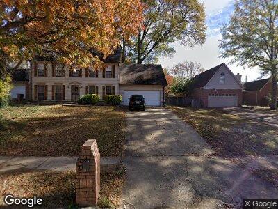
156 Rhonda Cir E Cordova, TN 38018
Estimated Value: $298,000
3
Beds
3
Baths
2,162
Sq Ft
$138/Sq Ft
Est. Value
About This Home
This home is located at 156 Rhonda Cir E, Cordova, TN 38018 and is currently estimated at $298,000, approximately $137 per square foot. 156 Rhonda Cir E is a home located in Shelby County with nearby schools including Cordova Elementary School, Cordova Middle School, and Cordova High School.
Ownership History
Date
Name
Owned For
Owner Type
Purchase Details
Closed on
Mar 30, 2022
Sold by
Sean Collins
Bought by
Rs Rental Iii-A Llc
Current Estimated Value
Purchase Details
Closed on
Apr 28, 2017
Sold by
Beaty Douglas R
Bought by
Collins Sean and Global Pro Trust
Purchase Details
Closed on
Aug 22, 2008
Sold by
Wring Real Estate Llc
Bought by
Wring Bruce
Purchase Details
Closed on
Apr 30, 2004
Sold by
Henderson Margaret
Bought by
Hud
Purchase Details
Closed on
Jan 15, 2001
Sold by
Ray Ann D
Bought by
Henderson Margaret
Home Financials for this Owner
Home Financials are based on the most recent Mortgage that was taken out on this home.
Original Mortgage
$143,744
Interest Rate
7.44%
Mortgage Type
FHA
Create a Home Valuation Report for This Property
The Home Valuation Report is an in-depth analysis detailing your home's value as well as a comparison with similar homes in the area
Home Values in the Area
Average Home Value in this Area
Purchase History
| Date | Buyer | Sale Price | Title Company |
|---|---|---|---|
| Rs Rental Iii-A Llc | $7,004,390 | None Listed On Document | |
| Collins Sean | -- | None Available | |
| Wring Bruce | -- | None Available | |
| Hud | $155,347 | -- | |
| Henderson Margaret | $146,000 | -- |
Source: Public Records
Mortgage History
| Date | Status | Borrower | Loan Amount |
|---|---|---|---|
| Previous Owner | Wring Bruce | $123,200 | |
| Previous Owner | Henderson Margaret | $143,744 | |
| Previous Owner | Ray James Jerrel | $97,638 | |
| Closed | Henderson Margaret | $4,119 |
Source: Public Records
Tax History Compared to Growth
Tax History
| Year | Tax Paid | Tax Assessment Tax Assessment Total Assessment is a certain percentage of the fair market value that is determined by local assessors to be the total taxable value of land and additions on the property. | Land | Improvement |
|---|---|---|---|---|
| 2025 | $1,631 | $64,250 | $15,250 | $49,000 |
| 2024 | $1,631 | $48,125 | $9,525 | $38,600 |
| 2023 | $1,631 | $48,125 | $9,525 | $38,600 |
| 2022 | $1,631 | $48,125 | $9,525 | $38,600 |
| 2021 | $1,949 | $48,125 | $9,525 | $38,600 |
Source: Public Records
Map
Nearby Homes
- 8678 Dena Cove E
- 8747 Walnut Grove Rd
- 79 Shelley Renee Ln
- 8653 Chris Suzanne Cir
- 178 Mysen Cir
- 8859 Plantation Trail Cove
- 8579 Ericson Cove
- 240 Mysen Dr
- 0 Walnut Grove Rd
- 167 Ericson Rd
- 345 Locust Grove Dr
- 8534 Shady Trail Cove
- 8930 Freeman Oaks Cove
- 373 Meadow Trail Cove
- 371 Shelley Renee Ln
- 388 Shelley Renee Ln
- 175 Walnut Ridge Ln
- 8835 Orchard Park Cove
- 31 Autumn Grove Cove
- 8603 May Orchard Ln
- 156 Rhonda Cir E
- 130 Rhonda Cir E
- 196 Rhonda Cir E
- 122 Rhonda Cir E
- 155 S Sanga Rd
- 195 S Sanga Rd
- 125 S Sanga Rd
- 157 Rhonda Cir E
- 0 Alana Blvd Unit 3228602
- 0 Alana Blvd Unit 3228593
- 100 Rhonda Cir E
- 197 Rhonda Cir E
- 101 Rhonda Cir E
- 212 Rhonda Cir E
- 93 S Sanga Rd
- 205 Rhonda Cir E
- 92 Rhonda Cir E
- 8727 Artis Alan Ln
- 8695 Chris Suzanne Cir
- 8698 Chris Suzanne Cir