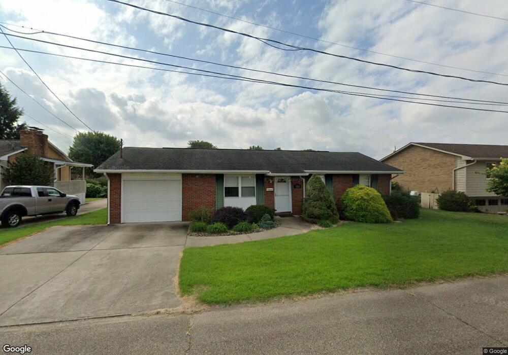
1567 Lois St Belpre, OH 45714
Estimated Value: $171,901 - $211,000
3
Beds
2
Baths
1,338
Sq Ft
$143/Sq Ft
Est. Value
About This Home
This home is located at 1567 Lois St, Belpre, OH 45714 and is currently estimated at $191,725, approximately $143 per square foot. 1567 Lois St is a home located in Washington County with nearby schools including Belpre Elementary School, Belpre High School, and Parkersburg Catholic Elementary School.
Ownership History
Date
Name
Owned For
Owner Type
Purchase Details
Closed on
Aug 7, 2002
Bought by
D M J Rentals Ltd
Current Estimated Value
Purchase Details
Closed on
Jul 3, 2000
Bought by
Dowler James E
Purchase Details
Closed on
Feb 18, 2000
Bought by
Stewart Martha
Purchase Details
Closed on
Aug 6, 1999
Bought by
Dowler Lawrence E
Purchase Details
Closed on
Jun 19, 1990
Bought by
Dowler Lawrence E and Dowler Beat
Create a Home Valuation Report for This Property
The Home Valuation Report is an in-depth analysis detailing your home's value as well as a comparison with similar homes in the area
Home Values in the Area
Average Home Value in this Area
Purchase History
| Date | Buyer | Sale Price | Title Company |
|---|---|---|---|
| D M J Rentals Ltd | $62,000 | -- | |
| D M J Rentals Ltd | $62,000 | -- | |
| Dowler James E | $44,800 | -- | |
| Dowler James E | $44,800 | -- | |
| Stewart Martha | -- | -- | |
| Stewart Martha | -- | -- | |
| Dowler Lawrence E | -- | -- | |
| Dowler Lawrence E | -- | -- | |
| Dowler Lawrence E | $45,000 | -- | |
| Dowler Lawrence E | $45,000 | -- |
Source: Public Records
Tax History
| Year | Tax Paid | Tax Assessment Tax Assessment Total Assessment is a certain percentage of the fair market value that is determined by local assessors to be the total taxable value of land and additions on the property. | Land | Improvement |
|---|---|---|---|---|
| 2024 | $3,064 | $43,210 | $6,370 | $36,840 |
| 2023 | $1,704 | $43,210 | $6,370 | $36,840 |
| 2022 | $1,695 | $43,210 | $6,370 | $36,840 |
| 2021 | $1,556 | $37,360 | $4,800 | $32,560 |
| 2020 | $1,561 | $37,360 | $4,800 | $32,560 |
| 2019 | $1,554 | $37,360 | $4,800 | $32,560 |
| 2018 | $1,497 | $35,400 | $4,360 | $31,040 |
| 2017 | $1,213 | $35,400 | $4,360 | $31,040 |
| 2016 | $1,762 | $35,400 | $4,360 | $31,040 |
| 2015 | $1,047 | $32,020 | $4,300 | $27,720 |
| 2014 | $1,596 | $32,020 | $4,300 | $27,720 |
| 2013 | $525 | $32,020 | $4,300 | $27,720 |
Source: Public Records
Map
Nearby Homes
- 710 Belrock Ave Unit 116
- 710 Belrock Ave
- 1587 Lois St
- 1310 Roselawn Ave
- 800 Talbot St
- 708 Oak Tree Ln
- 706 Oak Tree Ln Unit 706
- 750 Covey Ct
- 1109 4th St
- 1105 4th St
- 0 Lee St
- 906 Westview Dr
- 209 Lee St
- 00 Cherry Tree Dr
- 1806 Pennsylvania Ave
- 804 Franklin Ave
- 1317 Blennerhassett Ave Unit A
- 807 Clement Ave
- 976 Braun Rd
- 804 Hocking Rd
Your Personal Tour Guide
Ask me questions while you tour the home.