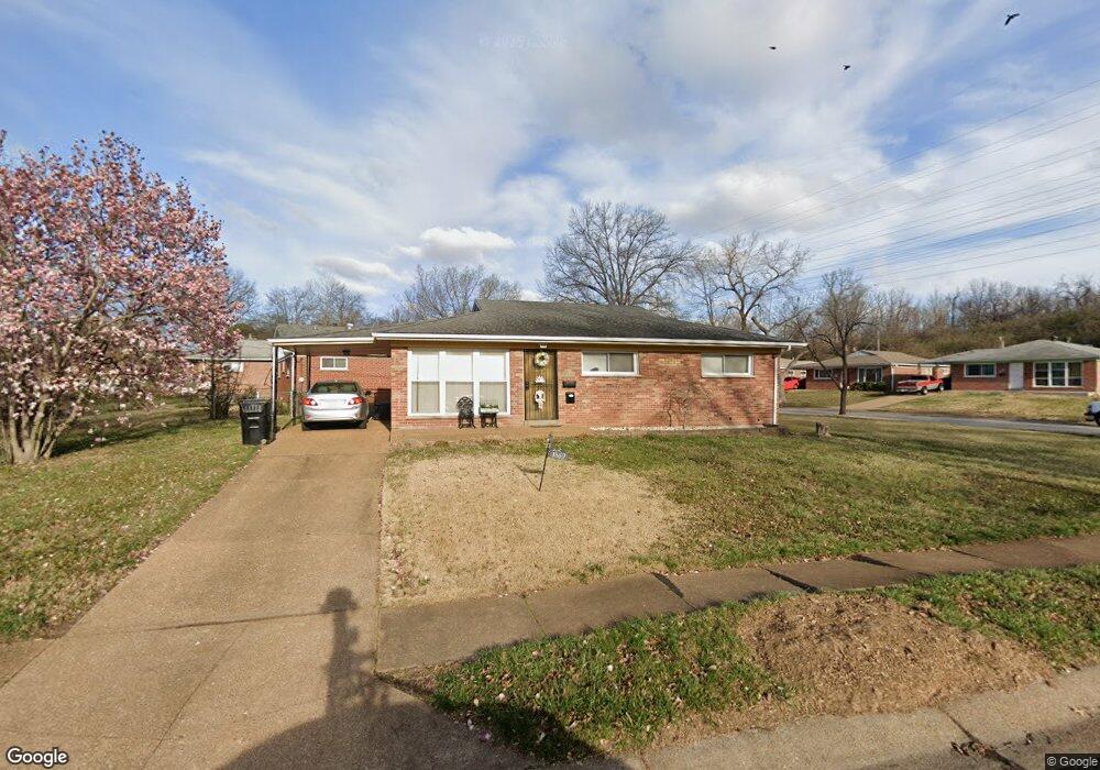
1569 Mendell Dr Saint Louis, MO 63130
Estimated Value: $150,000 - $235,000
3
Beds
2
Baths
1,200
Sq Ft
$157/Sq Ft
Est. Value
About This Home
This home is located at 1569 Mendell Dr, Saint Louis, MO 63130 and is currently estimated at $188,973, approximately $157 per square foot. 1569 Mendell Dr is a home located in St. Louis County with nearby schools including Barbara C. Jordan Elementary School, Brittany Woods Middle School, and University City High School.
Ownership History
Date
Name
Owned For
Owner Type
Purchase Details
Closed on
Jun 29, 2007
Sold by
Cronin Janet E
Bought by
Hayes Margaret B
Current Estimated Value
Home Financials for this Owner
Home Financials are based on the most recent Mortgage that was taken out on this home.
Original Mortgage
$142,000
Outstanding Balance
$86,889
Interest Rate
6.19%
Mortgage Type
Purchase Money Mortgage
Estimated Equity
$102,084
Purchase Details
Closed on
Oct 17, 2006
Sold by
Lounsbury John E and Lounsbury Dawn B
Bought by
Cronin Janel E and Bukhstaber Boris
Purchase Details
Closed on
Sep 29, 2006
Sold by
Abrams Alvin and Inselberg Evelyn
Bought by
Lounsbury John E and Lounsbury Dawn B
Create a Home Valuation Report for This Property
The Home Valuation Report is an in-depth analysis detailing your home's value as well as a comparison with similar homes in the area
Home Values in the Area
Average Home Value in this Area
Purchase History
| Date | Buyer | Sale Price | Title Company |
|---|---|---|---|
| Hayes Margaret B | $142,000 | None Available | |
| Cronin Janel E | $60,000 | None Available | |
| Lounsbury John E | $51,000 | Clt |
Source: Public Records
Mortgage History
| Date | Status | Borrower | Loan Amount |
|---|---|---|---|
| Open | Hayes Margaret B | $142,000 |
Source: Public Records
Tax History Compared to Growth
Tax History
| Year | Tax Paid | Tax Assessment Tax Assessment Total Assessment is a certain percentage of the fair market value that is determined by local assessors to be the total taxable value of land and additions on the property. | Land | Improvement |
|---|---|---|---|---|
| 2025 | $1,903 | $33,520 | $5,210 | $28,310 |
| 2024 | $1,903 | $26,310 | $2,410 | $23,900 |
| 2023 | $1,901 | $26,310 | $2,410 | $23,900 |
| 2022 | $1,550 | $19,870 | $3,610 | $16,260 |
| 2021 | $1,535 | $19,870 | $3,610 | $16,260 |
| 2020 | $1,495 | $18,850 | $3,950 | $14,900 |
| 2019 | $1,481 | $18,850 | $3,950 | $14,900 |
| 2018 | $1,416 | $16,640 | $3,570 | $13,070 |
| 2017 | $1,419 | $16,640 | $3,570 | $13,070 |
| 2016 | $1,585 | $17,860 | $3,190 | $14,670 |
| 2015 | $1,592 | $17,860 | $3,190 | $14,670 |
| 2014 | $1,437 | $15,790 | $3,690 | $12,100 |
Source: Public Records
Map
Nearby Homes
- 7831 Trenton Ave
- 8034 Appleton Dr
- 1349 Rushmore Dr
- 1459 Lyndale Ave
- 1323 Fairview Ave
- 1319 Rushmore Dr
- 8003 Briar Ct
- 1432 Tamerton Ave
- 8259 Paramount Dr
- 1243 Fairview Ave
- 7624 Fairham Ave
- 1237 Fairview Ave
- 8227 Page Ave
- 1357 N North and South Rd
- 8362 Braddock Dr
- 8334 Jackson St
- 8364 Fullerton Ave
- 1276 N and Rd S
- 8303 Jackson St
- 8450 Kempland Place
- 1581 Mendell Dr
- 1563 Mendell Dr
- 1587 Mendell Dr
- 1558 Mendell Dr
- 1562 Mendell Dr
- 1554 Mendell Dr
- 1584 Mendell Dr
- 1559 Mendell Dr
- 1580 Mendell Dr
- 1591 Mendell Dr
- 1588 Mendell Dr
- 1566 Mendell Dr
- 1550 Mendell Dr
- 1576 Mendell Dr
- 1555 Mendell Dr
- 1592 Mendell Dr
- 1595 Mendell Dr
- 1546 Mendell Dr
- 1598 Mendell Dr
- 1570 Mendell Dr