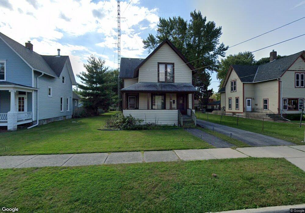
157 Oak St Elgin, IL 60123
Southwest Elgin NeighborhoodEstimated Value: $236,000 - $297,000
2
Beds
2
Baths
1,845
Sq Ft
$149/Sq Ft
Est. Value
About This Home
This home is located at 157 Oak St, Elgin, IL 60123 and is currently estimated at $275,200, approximately $149 per square foot. 157 Oak St is a home located in Kane County with nearby schools including Lowrie Elementary School, Abbott Middle School, and Larkin High School.
Ownership History
Date
Name
Owned For
Owner Type
Purchase Details
Closed on
Jun 19, 2007
Sold by
Andren Susan M
Bought by
Andren Richard M
Current Estimated Value
Home Financials for this Owner
Home Financials are based on the most recent Mortgage that was taken out on this home.
Original Mortgage
$146,394
Outstanding Balance
$90,448
Interest Rate
6.37%
Mortgage Type
New Conventional
Estimated Equity
$184,752
Create a Home Valuation Report for This Property
The Home Valuation Report is an in-depth analysis detailing your home's value as well as a comparison with similar homes in the area
Home Values in the Area
Average Home Value in this Area
Purchase History
| Date | Buyer | Sale Price | Title Company |
|---|---|---|---|
| Andren Richard M | -- | Acquest Title Services Llc |
Source: Public Records
Mortgage History
| Date | Status | Borrower | Loan Amount |
|---|---|---|---|
| Open | Andren Richard M | $146,394 |
Source: Public Records
Tax History Compared to Growth
Tax History
| Year | Tax Paid | Tax Assessment Tax Assessment Total Assessment is a certain percentage of the fair market value that is determined by local assessors to be the total taxable value of land and additions on the property. | Land | Improvement |
|---|---|---|---|---|
| 2024 | $5,824 | $80,773 | $15,901 | $64,872 |
| 2023 | $5,539 | $72,972 | $14,365 | $58,607 |
| 2022 | $5,249 | $66,537 | $13,098 | $53,439 |
| 2021 | $5,015 | $62,208 | $12,246 | $49,962 |
| 2020 | $4,869 | $59,387 | $11,691 | $47,696 |
| 2019 | $4,723 | $56,569 | $11,136 | $45,433 |
| 2018 | $4,676 | $53,292 | $10,491 | $42,801 |
| 2017 | $4,565 | $50,380 | $9,918 | $40,462 |
| 2016 | $4,345 | $46,739 | $9,201 | $37,538 |
| 2015 | -- | $42,841 | $8,434 | $34,407 |
| 2014 | -- | $42,312 | $8,330 | $33,982 |
| 2013 | -- | $43,428 | $8,550 | $34,878 |
Source: Public Records
Map
Nearby Homes
- 422 Ryerson Ave
- 50 S State St
- 331 Griswold St
- 414 Billings St
- 527 Ashland Ave
- 309 Griswold St
- 535 Ashland Ave
- 327 Billings St
- 302 Griswold St
- 603 Wellington Ave
- 518 Raymond St
- 261 Perry St
- 661 Wellington Ave
- 364 Bent St
- 515 Adams St
- 277 Gifford Place
- 150 Festival Ct
- 270 Villa St
- 210 Orchard St
- 422 Locust St
- 153 Oak St
- 165 Oak St
- 133 Oak St
- 158 Harding St
- 162 Harding St Unit 164
- 411 Ryerson Ave
- 154 Oak St
- 164 Oak St
- 164 Oak St Unit LOWER
- 164 Oak St Unit UPPER
- 166 Harding St Unit 168
- 168 Harding St Unit Duplex
- 168 Harding St
- 129 Oak St
- 114 Harding St
- 407 S State St
- 403 S State St
- 380 Ryerson Ave
- 413 S State St
- 387 Ryerson Ave