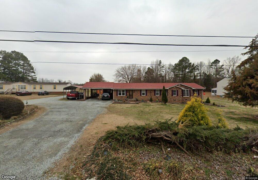
1579 Semora Rd Roxboro, NC 27574
Estimated Value: $324,000 - $362,836
Studio
3
Baths
2,407
Sq Ft
$145/Sq Ft
Est. Value
About This Home
This home is located at 1579 Semora Rd, Roxboro, NC 27574 and is currently estimated at $349,612, approximately $145 per square foot. 1579 Semora Rd is a home located in Person County with nearby schools including Person High School, Roxboro Community School, and Roxboro Christian Academy.
Ownership History
Date
Name
Owned For
Owner Type
Purchase Details
Closed on
Feb 3, 2017
Sold by
Winstead Thursher G and Winstead Donald R
Bought by
Winstead Donald R
Current Estimated Value
Home Financials for this Owner
Home Financials are based on the most recent Mortgage that was taken out on this home.
Original Mortgage
$96,800
Outstanding Balance
$48,912
Interest Rate
4.2%
Mortgage Type
New Conventional
Estimated Equity
$300,700
Purchase Details
Closed on
Apr 30, 2008
Sold by
Winstead Thursher G and Winstead Donald R
Bought by
Winstead Thursher G and Winstead Donald R
Home Financials for this Owner
Home Financials are based on the most recent Mortgage that was taken out on this home.
Original Mortgage
$119,000
Interest Rate
5.84%
Mortgage Type
Purchase Money Mortgage
Create a Home Valuation Report for This Property
The Home Valuation Report is an in-depth analysis detailing your home's value as well as a comparison with similar homes in the area
Purchase History
| Date | Buyer | Sale Price | Title Company |
|---|---|---|---|
| Winstead Donald R | -- | None Available | |
| Winstead Thursher G | -- | -- |
Source: Public Records
Mortgage History
| Date | Status | Borrower | Loan Amount |
|---|---|---|---|
| Open | Winstead Donald R | $96,800 | |
| Previous Owner | Winstead Thursher G | $119,000 |
Source: Public Records
Tax History
| Year | Tax Paid | Tax Assessment Tax Assessment Total Assessment is a certain percentage of the fair market value that is determined by local assessors to be the total taxable value of land and additions on the property. | Land | Improvement |
|---|---|---|---|---|
| 2025 | $1,842 | $323,907 | $0 | $0 |
| 2024 | $1,526 | $196,791 | $0 | $0 |
| 2023 | $1,526 | $196,791 | $0 | $0 |
| 2022 | $1,521 | $196,791 | $0 | $0 |
| 2021 | $1,477 | $196,791 | $0 | $0 |
| 2020 | $1,123 | $149,487 | $0 | $0 |
| 2019 | $1,138 | $149,487 | $0 | $0 |
| 2018 | $1,067 | $149,487 | $0 | $0 |
| 2017 | $1,045 | $149,487 | $0 | $0 |
| 2016 | $1,052 | $149,487 | $0 | $0 |
| 2015 | $1,052 | $149,487 | $0 | $0 |
| 2014 | $1,052 | $149,487 | $0 | $0 |
Source: Public Records
Map
Nearby Homes
- 500 Jones Lester Rd
- 2 Semora Rd
- 98 Lochridge Dr
- 1.5 Acres Burlington Rd
- 70 Younger Rd
- 40 John D Winstead Rd
- 9 Buttonwood Ln
- 209 Reade Dr
- 310 Wesleyan Heights Rd
- 382 Wimbledon Dr
- 515 Reams Ave
- 213 Hill St
- 420 Reams Ave
- 531 Booth St
- 2337 Burlington Rd
- 508 Jones St
- 50 Southern Village Dr
- Lot 3 Hurdle Mills Rd
- 184 Payton Place
- 1739 Hurdle Mills Rd
- 1611 Semora Rd
- 1535 Semora Rd
- 1564 Semora Rd
- 658 Robert Norris Rd
- 636 Robert Norris Rd
- 1507 Semora Rd
- 614 Robert Norris Rd
- 1652 Semora Rd
- 1504 Semora Rd
- 594 Robert Norris Rd
- 671 Robert Norris Rd
- 643 Robert Norris Rd
- 574 Robert Norris Rd
- 1469 Semora Rd
- 1474 Semora Rd
- 1450 Semora Rd
- 548 Robert Norris Rd
- 69 Jones Lester Rd
- Lot B Semora Rd
- 585 Robert Norris Rd
Your Personal Tour Guide
Ask me questions while you tour the home.