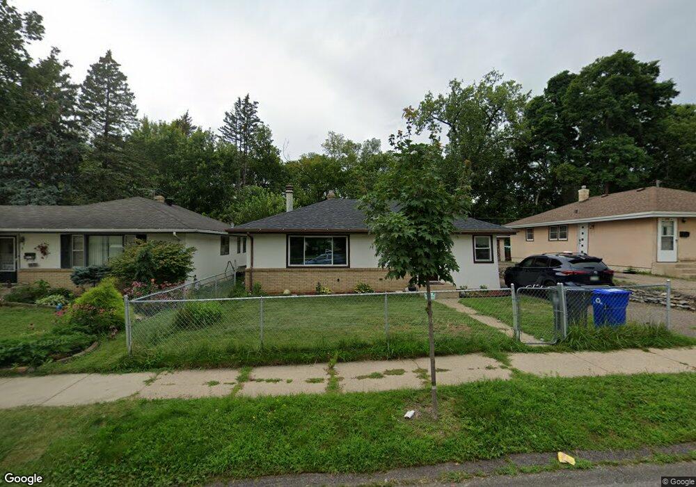
1595 Mcafee St Saint Paul, MN 55106
Estimated Value: $275,000 - $292,891
2
Beds
2
Baths
559
Sq Ft
$507/Sq Ft
Est. Value
About This Home
This home is located at 1595 Mcafee St, Saint Paul, MN 55106 and is currently estimated at $283,473, approximately $507 per square foot. 1595 Mcafee St is a home located in Ramsey County with nearby schools including Frost Lake Elementary School, Txuj Ci HMong Language and Culture Upper Campus, and Johnson Senior High School.
Ownership History
Date
Name
Owned For
Owner Type
Purchase Details
Closed on
May 15, 2010
Sold by
Stordalen Christopher J and Eckes Jennifer K
Bought by
Vang Ong Na
Current Estimated Value
Home Financials for this Owner
Home Financials are based on the most recent Mortgage that was taken out on this home.
Original Mortgage
$213,400
Interest Rate
3.2%
Mortgage Type
New Conventional
Purchase Details
Closed on
Sep 12, 2002
Sold by
Merrill Eric J and Merrill Cindy
Bought by
Stordalen Christopher J and Eckes Jennifer J
Create a Home Valuation Report for This Property
The Home Valuation Report is an in-depth analysis detailing your home's value as well as a comparison with similar homes in the area
Home Values in the Area
Average Home Value in this Area
Purchase History
| Date | Buyer | Sale Price | Title Company |
|---|---|---|---|
| Vang Ong Na | $220,000 | Titlesmart Inc | |
| Stordalen Christopher J | $146,000 | -- |
Source: Public Records
Mortgage History
| Date | Status | Borrower | Loan Amount |
|---|---|---|---|
| Previous Owner | Vang Ong Na | $213,400 |
Source: Public Records
Tax History Compared to Growth
Tax History
| Year | Tax Paid | Tax Assessment Tax Assessment Total Assessment is a certain percentage of the fair market value that is determined by local assessors to be the total taxable value of land and additions on the property. | Land | Improvement |
|---|---|---|---|---|
| 2025 | $3,680 | $265,500 | $30,000 | $235,500 |
| 2023 | $3,680 | $246,800 | $25,000 | $221,800 |
| 2022 | $3,260 | $269,500 | $25,000 | $244,500 |
| 2021 | $2,860 | $214,300 | $25,000 | $189,300 |
| 2020 | $2,698 | $197,000 | $13,900 | $183,100 |
| 2019 | $2,534 | $176,400 | $13,900 | $162,500 |
| 2018 | $2,310 | $164,800 | $13,900 | $150,900 |
| 2017 | $2,016 | $156,700 | $13,900 | $142,800 |
| 2016 | $1,912 | $0 | $0 | $0 |
| 2015 | $1,780 | $134,400 | $13,900 | $120,500 |
| 2014 | $1,440 | $0 | $0 | $0 |
Source: Public Records
Map
Nearby Homes
- 1639 Clarence St
- 1567 Atlantic St
- 1672 Manton St
- 1730 Atlantic St
- 1714 Duluth St
- 1751 Clarence St
- 1435 Price Ave
- 1450 Arlington Ave E
- 1377 Clarence St
- 1357 Birmingham St
- 1532 Larpenteur Ave E
- 1583 Nevada Ave E
- 1607 Hoyt Ave E
- 1870 Clarence St
- 866 Clear Ave E
- 1869 Birmingham St
- 1637 Iowa Ave E
- 1627 Christie Place
- 1854 Barclay St
- 1229 Clarence St
- 1589 Mcafee St
- 1599 Mcafee St
- 1585 Mcafee St
- 1605 1605 McAfee-street-
- 1605 Mcafee St
- 1581 Mcafee St
- 1609 Mcafee St
- 1592 Mcafee St
- 1588 Mcafee St
- 1598 Mcafee St
- 1598 1598 McAfee-street-
- 1577 Mcafee St
- 1577 1577 McAfee-street-
- 1584 Mcafee St
- 1606 Mcafee St
- 1615 Mcafee St
- 1574 Mcafee St
- 1614 Mcafee St
- 1594 N English St Unit 1S
- 1594 N English St