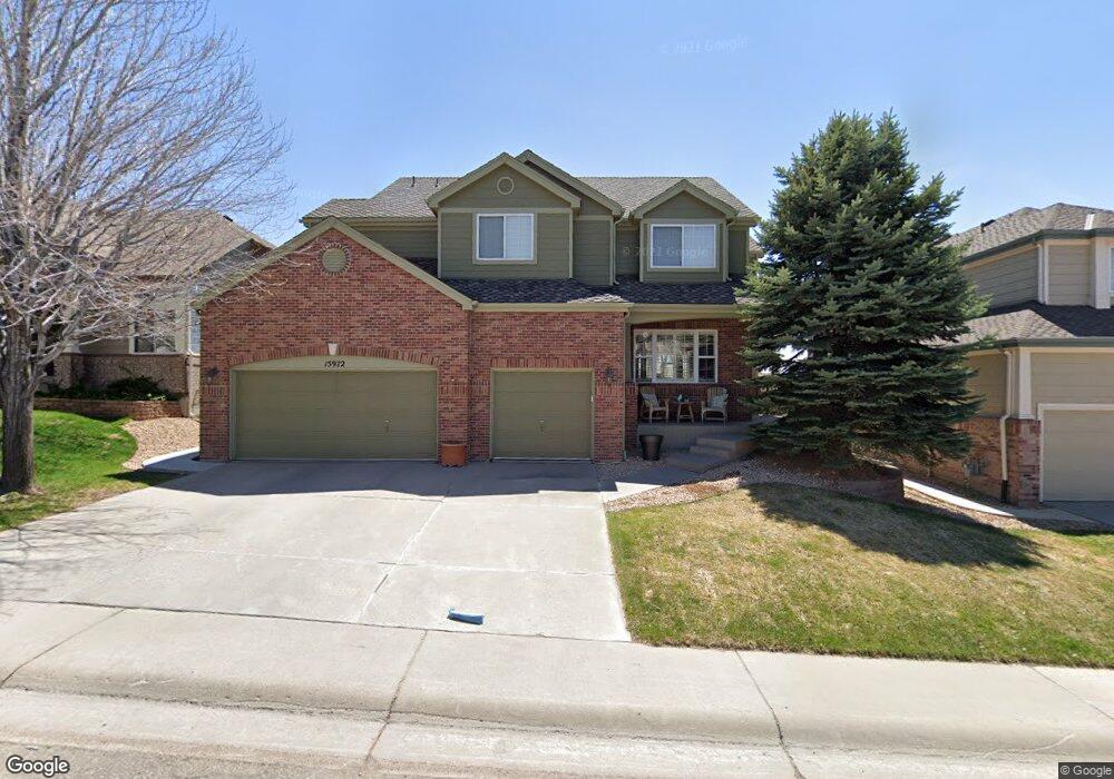
15972 Crestrock Cir Parker, CO 80134
Stonegate NeighborhoodEstimated Value: $733,242 - $769,000
4
Beds
3
Baths
3,281
Sq Ft
$227/Sq Ft
Est. Value
About This Home
This home is located at 15972 Crestrock Cir, Parker, CO 80134 and is currently estimated at $744,561, approximately $226 per square foot. 15972 Crestrock Cir is a home located in Douglas County with nearby schools including Pine Grove Elementary School, Sierra Middle School, and Chaparral High School.
Ownership History
Date
Name
Owned For
Owner Type
Purchase Details
Closed on
Jun 15, 2010
Sold by
Saltamachio Gregory A and Saltamachio Lori Marie
Bought by
Mcabee Keith and Mcabee Maggie
Current Estimated Value
Home Financials for this Owner
Home Financials are based on the most recent Mortgage that was taken out on this home.
Original Mortgage
$360,000
Outstanding Balance
$240,086
Interest Rate
4.87%
Mortgage Type
VA
Estimated Equity
$504,475
Purchase Details
Closed on
May 5, 2008
Sold by
Hered John David and Hered Deidre S
Bought by
Saltamachio Gregory A and Saltamachio Lori Marie
Home Financials for this Owner
Home Financials are based on the most recent Mortgage that was taken out on this home.
Original Mortgage
$342,659
Interest Rate
5.89%
Mortgage Type
FHA
Purchase Details
Closed on
Jun 23, 2004
Sold by
Kitzman Jeremy J and Kitzman Jennifer E
Bought by
Hered John David and Hered Deidre S
Home Financials for this Owner
Home Financials are based on the most recent Mortgage that was taken out on this home.
Original Mortgage
$279,900
Interest Rate
1.25%
Mortgage Type
Negative Amortization
Purchase Details
Closed on
Jun 19, 2001
Sold by
Deagazio William J and Deagazio Mary G
Bought by
Kitzman Jeremy J and Kitzman Jennifer E
Home Financials for this Owner
Home Financials are based on the most recent Mortgage that was taken out on this home.
Original Mortgage
$275,000
Interest Rate
6.88%
Purchase Details
Closed on
Feb 22, 1999
Sold by
Deagazio William J and Mesquida Mary G
Bought by
Deagazio William J and Deagazio Mary G
Purchase Details
Closed on
Dec 12, 1996
Sold by
Falcon Partnership Ltd
Bought by
Deagazio William J and Mesquida Mary G
Home Financials for this Owner
Home Financials are based on the most recent Mortgage that was taken out on this home.
Original Mortgage
$185,000
Interest Rate
7.6%
Purchase Details
Closed on
Mar 29, 1996
Sold by
Stonegate Dev Inc
Bought by
Falcon Partnership
Create a Home Valuation Report for This Property
The Home Valuation Report is an in-depth analysis detailing your home's value as well as a comparison with similar homes in the area
Home Values in the Area
Average Home Value in this Area
Purchase History
| Date | Buyer | Sale Price | Title Company |
|---|---|---|---|
| Mcabee Keith | $360,000 | Fidelity National Title Co | |
| Saltamachio Gregory A | $347,500 | Land Title Guarantee Company | |
| Hered John David | $349,900 | Land Title Guarantee Company | |
| Kitzman Jeremy J | $348,000 | -- | |
| Deagazio William J | -- | -- | |
| Deagazio William J | $248,015 | Land Title | |
| Falcon Partnership | $174,800 | -- |
Source: Public Records
Mortgage History
| Date | Status | Borrower | Loan Amount |
|---|---|---|---|
| Open | Mcabee Keith | $360,000 | |
| Previous Owner | Saltamachio Gregory A | $342,659 | |
| Previous Owner | Hered John David | $279,900 | |
| Previous Owner | Kitzman Jeremy J | $275,000 | |
| Previous Owner | Deagazio William J | $185,000 |
Source: Public Records
Tax History Compared to Growth
Tax History
| Year | Tax Paid | Tax Assessment Tax Assessment Total Assessment is a certain percentage of the fair market value that is determined by local assessors to be the total taxable value of land and additions on the property. | Land | Improvement |
|---|---|---|---|---|
| 2024 | $4,771 | $48,240 | $9,680 | $38,560 |
| 2023 | $4,812 | $48,240 | $9,680 | $38,560 |
| 2022 | $4,096 | $37,110 | $6,580 | $30,530 |
| 2021 | $4,213 | $37,110 | $6,580 | $30,530 |
| 2020 | $4,018 | $36,290 | $7,780 | $28,510 |
| 2019 | $3,921 | $36,290 | $7,780 | $28,510 |
| 2018 | $3,545 | $32,370 | $7,010 | $25,360 |
| 2017 | $3,343 | $32,370 | $7,010 | $25,360 |
| 2016 | $3,335 | $31,780 | $6,410 | $25,370 |
| 2015 | $3,399 | $31,780 | $6,410 | $25,370 |
| 2014 | $3,248 | $27,380 | $6,220 | $21,160 |
Source: Public Records
Map
Nearby Homes
- 10553 Stonemeadow Dr
- 10828 Snowdon St
- 10834 Snowdon St
- 10832 Tundra Top Dr
- 10676 Cottoneaster Way
- 10849 Tundra Top Dr
- 16116 Martingale Dr
- 10873 Tundra Top Dr
- 10896 Snowdon St
- 10818 Mcclellan Rd
- 15733 Mccauley Dr
- 10730 Tomboy Dr
- Pinnacle Plan at Newlin Crossing - The Pioneer Collection
- Graham Plan at Newlin Crossing - The Monarch Collection
- Ashbrook Plan at Newlin Crossing - The Monarch Collection
- Evans Plan at Newlin Crossing - The Pioneer Collection
- Stonehaven Plan at Newlin Crossing - The Monarch Collection
- 10734 Tomboy Dr
- Chelton Plan at Newlin Crossing - The Monarch Collection
- Elbert Plan at Newlin Crossing - The Pioneer Collection
- 15982 Crestrock Cir
- 15962 Crestrock Cir
- 15952 Crestrock Cir
- 15992 Crestrock Cir
- 10677 Stone Creek Ct
- 10678 Stone Creek Ct
- 16002 Crestrock Cir
- 15942 Crestrock Cir
- 15921 Crestrock Cir
- 10667 Stone Creek Ct
- 10668 Stone Creek Ct
- 16012 Crestrock Cir
- 15911 Crestrock Cir
- 10689 Singleleaf Ct
- 15932 Crestrock Cir
- 10657 Stone Creek Ct
- 10658 Stone Creek Ct
- 10679 Singleleaf Ct
- 16022 Crestrock Cir
- 15901 Crestrock Cir