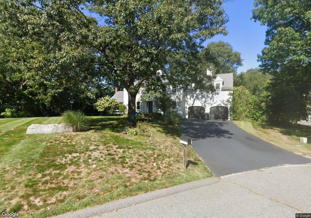
16 Carbone Ln Cohasset, MA 02025
Estimated Value: $1,713,000 - $2,217,000
4
Beds
4
Baths
3,700
Sq Ft
$529/Sq Ft
Est. Value
About This Home
This home is located at 16 Carbone Ln, Cohasset, MA 02025 and is currently estimated at $1,956,526, approximately $528 per square foot. 16 Carbone Ln is a home located in Norfolk County with nearby schools including Joseph Osgood School, Deer Hill School, and Cohasset Middle School.
Ownership History
Date
Name
Owned For
Owner Type
Purchase Details
Closed on
Apr 4, 2008
Sold by
Grech Matthew J
Bought by
Grech Kelly T and Grech Matthew J
Current Estimated Value
Purchase Details
Closed on
Aug 31, 1998
Sold by
Friel Gregory C and Friel Elise D
Bought by
Grech Matthew J
Purchase Details
Closed on
Jun 6, 1997
Sold by
Iantosca Bldg Co Inc
Bought by
Friel Gregory C and Friel Elise D
Create a Home Valuation Report for This Property
The Home Valuation Report is an in-depth analysis detailing your home's value as well as a comparison with similar homes in the area
Home Values in the Area
Average Home Value in this Area
Purchase History
| Date | Buyer | Sale Price | Title Company |
|---|---|---|---|
| Grech Kelly T | -- | -- | |
| Grech Kelly T | -- | -- | |
| Grech Matthew J | $470,000 | -- | |
| Grech Matthew J | $470,000 | -- | |
| Friel Gregory C | $439,900 | -- | |
| Friel Gregory C | $439,900 | -- |
Source: Public Records
Mortgage History
| Date | Status | Borrower | Loan Amount |
|---|---|---|---|
| Previous Owner | Friel Gregory C | $372,000 | |
| Previous Owner | Friel Gregory C | $372,000 |
Source: Public Records
Tax History Compared to Growth
Tax History
| Year | Tax Paid | Tax Assessment Tax Assessment Total Assessment is a certain percentage of the fair market value that is determined by local assessors to be the total taxable value of land and additions on the property. | Land | Improvement |
|---|---|---|---|---|
| 2025 | $18,229 | $1,574,200 | $692,400 | $881,800 |
| 2024 | $18,188 | $1,494,500 | $577,000 | $917,500 |
| 2023 | $16,213 | $1,374,000 | $577,000 | $797,000 |
| 2022 | $14,096 | $1,122,300 | $378,000 | $744,300 |
| 2021 | $13,916 | $1,067,200 | $378,000 | $689,200 |
| 2020 | $12,945 | $998,100 | $308,900 | $689,200 |
| 2019 | $12,875 | $998,100 | $308,900 | $689,200 |
| 2018 | $12,766 | $998,100 | $308,900 | $689,200 |
| 2017 | $12,363 | $946,600 | $294,100 | $652,500 |
| 2016 | $12,192 | $946,600 | $294,100 | $652,500 |
| 2015 | $12,031 | $946,600 | $294,100 | $652,500 |
| 2014 | $11,870 | $946,600 | $294,100 | $652,500 |
Source: Public Records
Map
Nearby Homes
- 508 Beechwood St
- 99 Doane St
- 94 Arrowwood Dr
- 0 Bates Ln (Lot E Kevin's Way) Unit 73419598
- 449 Clapp Rd
- 455 Clapp Rd
- 453 Clapp Rd
- 451 Clapp Rd
- 453 - 455 Clapp Rd
- 342 Summer St
- 40 Brewster Rd
- 8 Trudys Ln
- 84 Booth Hill Rd
- 334 Summer St
- 11 Forest Ln
- 9 Forest Ln Unit 9
- 46 Pond St
- 817 Country Way
- 100 Pond St Unit 10
- 9 Kyle Path