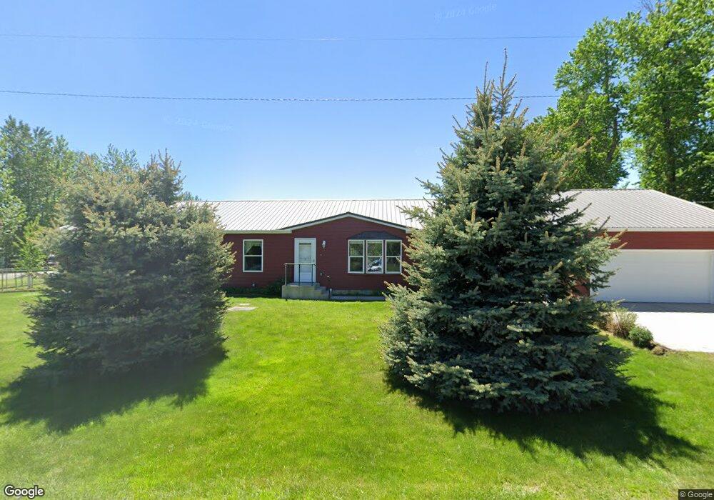
16 Cedar St Roberts, MT 59070
Roberts NeighborhoodEstimated Value: $350,000 - $1,072,000
3
Beds
2
Baths
2,520
Sq Ft
$216/Sq Ft
Est. Value
About This Home
This home is located at 16 Cedar St, Roberts, MT 59070 and is currently estimated at $545,360, approximately $216 per square foot. 16 Cedar St is a home located in Carbon County with nearby schools including Roberts School.
Ownership History
Date
Name
Owned For
Owner Type
Purchase Details
Closed on
Mar 5, 2014
Sold by
Phillips Bruce H and Phillips Bernice M
Bought by
White Christopher J and White Jahna L
Current Estimated Value
Home Financials for this Owner
Home Financials are based on the most recent Mortgage that was taken out on this home.
Original Mortgage
$104,000
Outstanding Balance
$30,619
Interest Rate
4.34%
Mortgage Type
New Conventional
Estimated Equity
$514,741
Create a Home Valuation Report for This Property
The Home Valuation Report is an in-depth analysis detailing your home's value as well as a comparison with similar homes in the area
Home Values in the Area
Average Home Value in this Area
Purchase History
| Date | Buyer | Sale Price | Title Company |
|---|---|---|---|
| White Christopher J | $130,000 | -- |
Source: Public Records
Mortgage History
| Date | Status | Borrower | Loan Amount |
|---|---|---|---|
| Open | White Christopher J | $104,000 |
Source: Public Records
Tax History Compared to Growth
Tax History
| Year | Tax Paid | Tax Assessment Tax Assessment Total Assessment is a certain percentage of the fair market value that is determined by local assessors to be the total taxable value of land and additions on the property. | Land | Improvement |
|---|---|---|---|---|
| 2025 | $1,273 | $408,500 | $0 | $0 |
| 2024 | $2,095 | $279,300 | $0 | $0 |
| 2023 | $1,948 | $279,300 | $0 | $0 |
| 2022 | $1,956 | $247,000 | $0 | $0 |
| 2021 | $1,690 | $247,000 | $0 | $0 |
| 2020 | $1,886 | $208,700 | $0 | $0 |
| 2019 | $1,938 | $208,700 | $0 | $0 |
| 2018 | $2,165 | $235,900 | $0 | $0 |
| 2017 | $2,222 | $235,900 | $0 | $0 |
| 2016 | $2,206 | $237,000 | $0 | $0 |
| 2015 | $1,591 | $237,000 | $0 | $0 |
| 2014 | $1,476 | $122,505 | $0 | $0 |
Source: Public Records
Map
Nearby Homes
- 101 S 2nd St
- 302 S Railway Ave
- 58 Cooney Rd
- 40 Acres Maki Johnson Rd
- 100 Laptop Loop
- 31 Painted Ln
- 39 Moose Tracks Dr
- 25 Painted Ln
- not assigned Laptop Loop
- 151 Laptop Loop
- 13 Wireless Way
- 11 Backup St
- 0 Laptop Loop
- 0 Backup St
- 89 Wild Rose Trail
- 5 Cursor Cir
- TBD Laptop Loop
- 50 Big Sky Ln
- 48 Buttercup Dr
- 20 Rosebud View