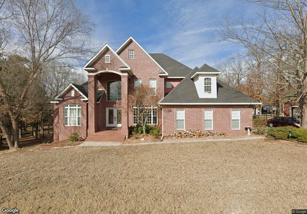
16 Jaime Ln Clarksville, AR 72830
Estimated Value: $382,434 - $460,000
5
Beds
4
Baths
3,397
Sq Ft
$123/Sq Ft
Est. Value
About This Home
This home is located at 16 Jaime Ln, Clarksville, AR 72830 and is currently estimated at $417,859, approximately $123 per square foot. 16 Jaime Ln is a home located in Johnson County with nearby schools including Clarksville Primary School, Clarksville Elementary School, and Clarksville Middle School.
Ownership History
Date
Name
Owned For
Owner Type
Purchase Details
Closed on
Sep 26, 2012
Sold by
Freeman Christopher and Freeman Holly
Bought by
Hoover Jason D
Current Estimated Value
Home Financials for this Owner
Home Financials are based on the most recent Mortgage that was taken out on this home.
Original Mortgage
$274,928
Outstanding Balance
$188,031
Interest Rate
3.25%
Mortgage Type
FHA
Estimated Equity
$229,828
Purchase Details
Closed on
Jun 26, 2007
Sold by
Regions Bank An Alabama Corporation
Bought by
Freeman Christopher and Freeman Holly
Home Financials for this Owner
Home Financials are based on the most recent Mortgage that was taken out on this home.
Original Mortgage
$285,000
Interest Rate
6.37%
Mortgage Type
Future Advance Clause Open End Mortgage
Purchase Details
Closed on
Jan 29, 2001
Bought by
Eppinette David and Eppinette Donna
Purchase Details
Closed on
Jul 27, 1995
Bought by
Mccarley Ricky D and Mccarley Lisa
Create a Home Valuation Report for This Property
The Home Valuation Report is an in-depth analysis detailing your home's value as well as a comparison with similar homes in the area
Home Values in the Area
Average Home Value in this Area
Purchase History
| Date | Buyer | Sale Price | Title Company |
|---|---|---|---|
| Hoover Jason D | -- | Curran'S Abstract & Title | |
| Freeman Christopher | -- | Curran'S Abstract | |
| Eppinette David | $12,000 | -- | |
| Mccarley Ricky D | $11,000 | -- |
Source: Public Records
Mortgage History
| Date | Status | Borrower | Loan Amount |
|---|---|---|---|
| Open | Hoover Jason D | $274,928 | |
| Previous Owner | Freeman Christopher | $285,000 |
Source: Public Records
Tax History Compared to Growth
Tax History
| Year | Tax Paid | Tax Assessment Tax Assessment Total Assessment is a certain percentage of the fair market value that is determined by local assessors to be the total taxable value of land and additions on the property. | Land | Improvement |
|---|---|---|---|---|
| 2024 | $2,940 | $66,390 | $3,000 | $63,390 |
| 2023 | $2,985 | $66,390 | $3,000 | $63,390 |
| 2022 | $2,893 | $66,390 | $3,000 | $63,390 |
| 2021 | $2,751 | $66,390 | $3,000 | $63,390 |
| 2020 | $2,609 | $66,390 | $3,000 | $63,390 |
| 2019 | $2,467 | $54,870 | $3,000 | $51,870 |
| 2018 | $2,492 | $54,870 | $3,000 | $51,870 |
| 2017 | $2,842 | $54,870 | $3,000 | $51,870 |
| 2015 | $2,229 | $54,870 | $3,000 | $51,870 |
| 2014 | -- | $56,180 | $3,000 | $53,180 |
| 2013 | -- | $56,180 | $3,000 | $53,180 |
Source: Public Records
Map
Nearby Homes
- 8 Mockingbird Ln
- 800 Ray Rd
- 252 Private Rd
- 102 Buffalo St
- 315 Private Road 3393
- 108 Sioux St
- 10 Killane St
- 111 Sioux St
- 725 N Montgomery St
- 715 N Montgomery St
- 205 Misty Ln
- 1207 N Harmony Rd
- 1113 N Harmony Rd
- 116 Stegall Rd
- 504 N Montgomery St
- 812 N Johnson St
- 1711 W Cline St
- 2240 W Main St
- 1807 Ford Dr
- 1107 Reynolds St