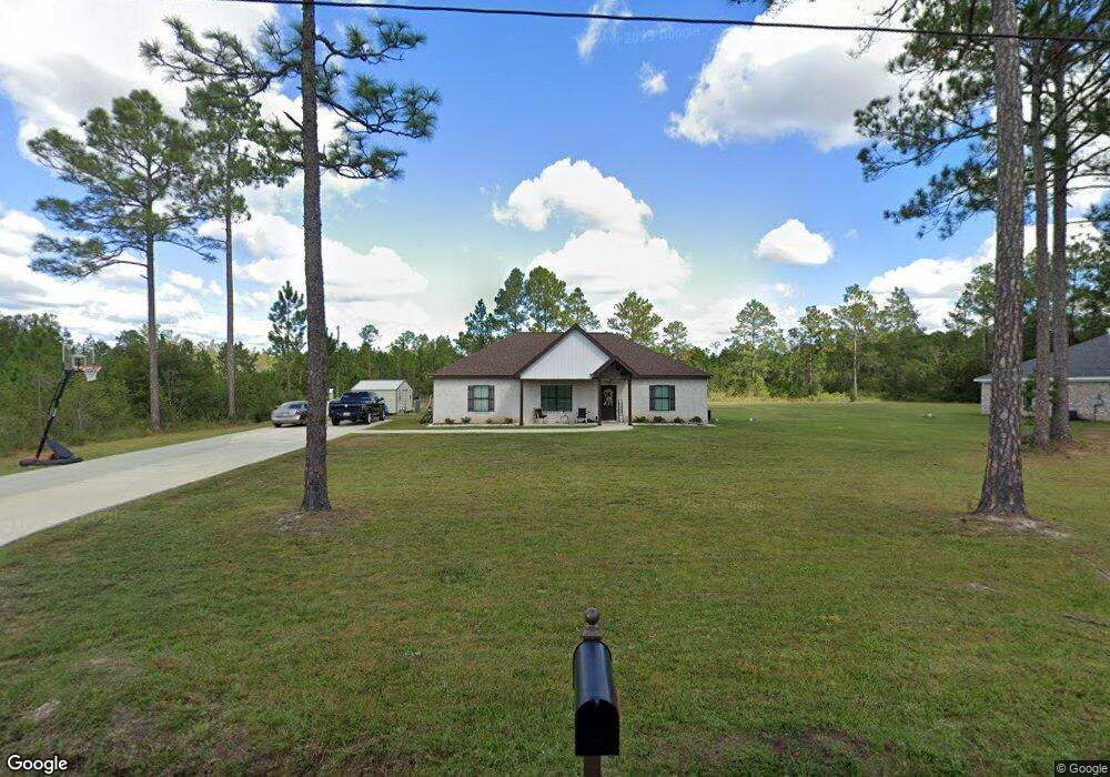
16000 Grafe Homestead Rd Moss Point, MS 39562
Estimated Value: $260,000 - $320,000
3
Beds
2
Baths
1,687
Sq Ft
$169/Sq Ft
Est. Value
About This Home
This home is located at 16000 Grafe Homestead Rd, Moss Point, MS 39562 and is currently estimated at $285,257, approximately $169 per square foot. 16000 Grafe Homestead Rd is a home located in Jackson County with nearby schools including East Central Lower Elementary School, East Central Upper Elementary School, and East Central Middle School.
Ownership History
Date
Name
Owned For
Owner Type
Purchase Details
Closed on
Dec 1, 2021
Sold by
Nathaniel Brewer Burl
Bought by
Brown Gregory Deon and Brown Konica N
Current Estimated Value
Home Financials for this Owner
Home Financials are based on the most recent Mortgage that was taken out on this home.
Original Mortgage
$206,100
Outstanding Balance
$189,634
Interest Rate
3.14%
Mortgage Type
New Conventional
Estimated Equity
$95,623
Purchase Details
Closed on
Dec 3, 2019
Sold by
Crosby Amy S
Bought by
Brewer Burl N and Ellison George G
Create a Home Valuation Report for This Property
The Home Valuation Report is an in-depth analysis detailing your home's value as well as a comparison with similar homes in the area
Home Values in the Area
Average Home Value in this Area
Purchase History
| Date | Buyer | Sale Price | Title Company |
|---|---|---|---|
| Brown Gregory Deon | -- | None Listed On Document | |
| Brewer Burl N | -- | None Available |
Source: Public Records
Mortgage History
| Date | Status | Borrower | Loan Amount |
|---|---|---|---|
| Open | Brown Gregory Deon | $206,100 |
Source: Public Records
Tax History Compared to Growth
Tax History
| Year | Tax Paid | Tax Assessment Tax Assessment Total Assessment is a certain percentage of the fair market value that is determined by local assessors to be the total taxable value of land and additions on the property. | Land | Improvement |
|---|---|---|---|---|
| 2024 | $1,426 | $14,383 | $1,099 | $13,284 |
| 2023 | $1,426 | $14,383 | $1,099 | $13,284 |
| 2022 | $1,378 | $14,383 | $1,099 | $13,284 |
| 2021 | $192 | $1,649 | $1,649 | $0 |
| 2020 | $364 | $3,017 | $2,381 | $636 |
| 2019 | $361 | $3,017 | $2,381 | $636 |
| 2018 | $391 | $3,212 | $2,381 | $831 |
| 2017 | $398 | $3,212 | $2,381 | $831 |
| 2016 | $382 | $3,212 | $2,381 | $831 |
| 2015 | $379 | $21,140 | $15,870 | $5,270 |
| 2014 | $373 | $3,172 | $2,381 | $791 |
| 2013 | $357 | $3,145 | $2,381 | $764 |
Source: Public Records
Map
Nearby Homes
- 0 Ms-613 Hwy Unit 4116583
- 0 Ms-613 Hwy Unit 4107607
- 0 Ms-613 Hwy Unit 4107612
- 0 Ms-613 Hwy Unit 4116582
- 7605 Methodist Church Rd
- 0 R B Dickerson Rd
- 27 Acres Brinkman Rd E
- 17500 Goff Farm Rd
- 0 Big Point Unit 4125782
- 13524 Highway 613
- 8200 Butler Rd
- 14505 Wolf Ridge Rd
- 18517 Goff Farm Rd
- 01 Dap Rd E
- -0- Rayford Shumock Rd
- 0 Dap Rd E
- 13109 Oak Haven Dr
- 0 Rayford Shumock Rd Unit 24406728
- 0 Rayford Shumock Rd Unit 4121875
- 8537 Augusta Rd
- 15938 Grafe Homestead Rd
- 15967 Grafe Homestead Rd
- 15932 Grafe Homestead Rd
- 15929 Grafe Homestead Rd
- 15928 Grafe Homestead Rd
- 15925 Grafe Homestead Rd
- 16036 Grafe Homestead Rd
- 6501 Big Point Rd
- 6400 Big Point Rd
- 0 Lilly Orchard St
- 15900 Grafe Homestead Rd
- 15920 Grafe Homestead Rd
- 15910 Grafe Homestead Rd
- 15904 Grafe Homestead Rd
- 15809 Vera Coleman Rd
- 15924 Grafe Homestead Rd
- 16037 Grafe Homestead Rd
- 16137 Grafe Homestead Rd
- 6612 Big Point Rd
- 15916 Grafe Homestead Rd