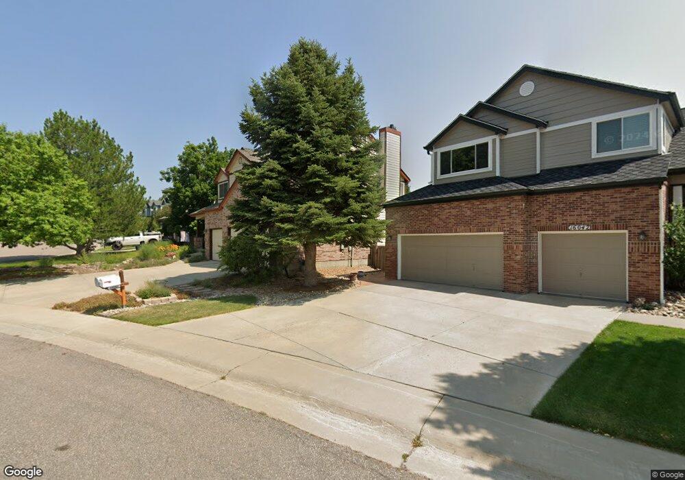
16052 Crestrock Cir Parker, CO 80134
Stonegate NeighborhoodEstimated Value: $707,000 - $758,000
4
Beds
4
Baths
2,573
Sq Ft
$288/Sq Ft
Est. Value
About This Home
This home is located at 16052 Crestrock Cir, Parker, CO 80134 and is currently estimated at $739,892, approximately $287 per square foot. 16052 Crestrock Cir is a home located in Douglas County with nearby schools including Pine Grove Elementary School, Sierra Middle School, and Chaparral High School.
Ownership History
Date
Name
Owned For
Owner Type
Purchase Details
Closed on
Feb 8, 2019
Sold by
Sanchez Robert E and Sanchez Heather B
Bought by
Sanchez Living Trust
Current Estimated Value
Purchase Details
Closed on
Sep 12, 1995
Sold by
Falcon Partnership Ltd
Bought by
Sanchez Robert E and Sanchez Heather B
Home Financials for this Owner
Home Financials are based on the most recent Mortgage that was taken out on this home.
Original Mortgage
$153,750
Interest Rate
7.78%
Purchase Details
Closed on
May 13, 1994
Sold by
Stonegate Dev Inc
Bought by
Falcon Partnership Ltd
Create a Home Valuation Report for This Property
The Home Valuation Report is an in-depth analysis detailing your home's value as well as a comparison with similar homes in the area
Home Values in the Area
Average Home Value in this Area
Purchase History
| Date | Buyer | Sale Price | Title Company |
|---|---|---|---|
| Sanchez Living Trust | -- | None Available | |
| Sanchez Robert E | $205,000 | Land Title | |
| Falcon Partnership Ltd | $314,900 | -- |
Source: Public Records
Mortgage History
| Date | Status | Borrower | Loan Amount |
|---|---|---|---|
| Closed | Sanchez Robert E | $153,750 |
Source: Public Records
Tax History Compared to Growth
Tax History
| Year | Tax Paid | Tax Assessment Tax Assessment Total Assessment is a certain percentage of the fair market value that is determined by local assessors to be the total taxable value of land and additions on the property. | Land | Improvement |
|---|---|---|---|---|
| 2024 | $5,196 | $52,210 | $10,690 | $41,520 |
| 2023 | $5,240 | $52,210 | $10,690 | $41,520 |
| 2022 | $3,950 | $35,780 | $7,160 | $28,620 |
| 2021 | $4,063 | $35,780 | $7,160 | $28,620 |
| 2020 | $3,972 | $35,870 | $8,380 | $27,490 |
| 2019 | $3,875 | $35,870 | $8,380 | $27,490 |
| 2018 | $3,471 | $31,690 | $7,580 | $24,110 |
| 2017 | $3,273 | $31,690 | $7,580 | $24,110 |
| 2016 | $3,223 | $30,710 | $6,410 | $24,300 |
| 2015 | $3,285 | $30,710 | $6,410 | $24,300 |
| 2014 | $3,074 | $25,910 | $6,220 | $19,690 |
Source: Public Records
Map
Nearby Homes
- 10553 Stonemeadow Dr
- 16116 Martingale Dr
- 10828 Snowdon St
- 10834 Snowdon St
- 10818 Mcclellan Rd
- 10832 Tundra Top Dr
- 10676 Cottoneaster Way
- 10849 Tundra Top Dr
- 10873 Tundra Top Dr
- 15565 Flowerhill Cir
- 10896 Snowdon St
- 16641 Martingale Dr
- 15733 Mccauley Dr
- 10312 Stoneflower Dr
- 10730 Tomboy Dr
- Pinnacle Plan at Newlin Crossing - The Pioneer Collection
- Graham Plan at Newlin Crossing - The Monarch Collection
- Ashbrook Plan at Newlin Crossing - The Monarch Collection
- Evans Plan at Newlin Crossing - The Pioneer Collection
- Stonehaven Plan at Newlin Crossing - The Monarch Collection
- 16106 Crestrock Ct
- 16042 Crestrock Cir
- 16122 Crestrock Ct
- 16032 Crestrock Cir
- 16051 Crestrock Cir
- 16031 Crestrock Cir
- 16138 Crestrock Ct
- 16022 Crestrock Cir
- 16121 Crestrock Ct
- 16061 Crestrock Cir
- 10765 Appaloosa Ct
- 16012 Crestrock Cir
- 16154 Crestrock Ct
- 10763 Appaloosa Ct
- 10670 Singleleaf Ct
- 16153 Crestrock Ct
- 10689 Singleleaf Ct
- 16002 Crestrock Cir
- 10759 Appaloosa Ct
- 16170 Crestrock Ct