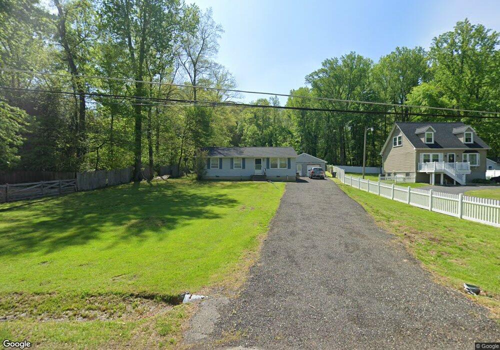
1609 Airport Ln Accokeek, MD 20607
Estimated Value: $359,000 - $390,378
--
Bed
2
Baths
1,008
Sq Ft
$367/Sq Ft
Est. Value
About This Home
This home is located at 1609 Airport Ln, Accokeek, MD 20607 and is currently estimated at $369,595, approximately $366 per square foot. 1609 Airport Ln is a home located in Prince George's County with nearby schools including Accokeek Academy, Gwynn Park High School, and St. Mary School.
Ownership History
Date
Name
Owned For
Owner Type
Purchase Details
Closed on
Jul 2, 2007
Sold by
Houck Bessie O
Bought by
Akinuli Dare
Current Estimated Value
Home Financials for this Owner
Home Financials are based on the most recent Mortgage that was taken out on this home.
Original Mortgage
$295,365
Outstanding Balance
$182,681
Interest Rate
6.39%
Mortgage Type
Purchase Money Mortgage
Estimated Equity
$186,914
Purchase Details
Closed on
Jun 22, 2007
Sold by
Houck Bessie O
Bought by
Akinuli Dare
Home Financials for this Owner
Home Financials are based on the most recent Mortgage that was taken out on this home.
Original Mortgage
$295,365
Outstanding Balance
$182,681
Interest Rate
6.39%
Mortgage Type
Purchase Money Mortgage
Estimated Equity
$186,914
Purchase Details
Closed on
Jun 16, 1986
Sold by
Southern Maryland
Bought by
Houck Bessie O
Create a Home Valuation Report for This Property
The Home Valuation Report is an in-depth analysis detailing your home's value as well as a comparison with similar homes in the area
Home Values in the Area
Average Home Value in this Area
Purchase History
| Date | Buyer | Sale Price | Title Company |
|---|---|---|---|
| Akinuli Dare | $300,000 | -- | |
| Akinuli Dare | $300,000 | -- | |
| Houck Bessie O | $71,100 | -- |
Source: Public Records
Mortgage History
| Date | Status | Borrower | Loan Amount |
|---|---|---|---|
| Open | Akinuli Dare | $295,365 | |
| Closed | Akinuli Dare | $295,365 |
Source: Public Records
Tax History Compared to Growth
Tax History
| Year | Tax Paid | Tax Assessment Tax Assessment Total Assessment is a certain percentage of the fair market value that is determined by local assessors to be the total taxable value of land and additions on the property. | Land | Improvement |
|---|---|---|---|---|
| 2025 | $4,517 | $298,000 | -- | -- |
| 2024 | $4,517 | $277,100 | $107,600 | $169,500 |
| 2023 | $4,241 | $258,600 | $0 | $0 |
| 2022 | $3,966 | $240,100 | $0 | $0 |
| 2021 | $3,691 | $221,600 | $101,300 | $120,300 |
| 2020 | $3,474 | $207,000 | $0 | $0 |
| 2019 | $3,257 | $192,400 | $0 | $0 |
| 2018 | $3,040 | $177,800 | $77,500 | $100,300 |
| 2017 | $3,040 | $177,800 | $0 | $0 |
| 2016 | -- | $177,800 | $0 | $0 |
| 2015 | $3,037 | $179,500 | $0 | $0 |
| 2014 | $3,037 | $179,500 | $0 | $0 |
Source: Public Records
Map
Nearby Homes
- Donovan Plan at St. James
- Hancock Plan at St. James
- Harmon Plan at St. James
- Preston Plan at St. James
- 14704 Livingston Rd
- 2024 Saint James Rd
- 2022 Saint James Rd
- 2004 Aram Dr
- 15206 Derbyshire Way
- 2003 Aram Dr
- 1410 Farmington Rd E
- 14708 Bisque St
- 2013 Saint James Rd
- 1217 Granada St
- 1108 Byron St
- 2010 Saint James Rd
- 1212 Granada St
- 1400 Farmington Rd E
- 1605 Saint James Rd
- 2008 Saint James Rd
- 1607 Airport Ln
- 1605 Airport Ln
- 14805 Berry Rd
- 14809 Berry Rd
- 1603 Airport Ln
- 1608 Airport Ln
- 1611 Airport Ln
- 14813 Berry Rd
- 1601 Airport Ln
- 1604 Airport Ln
- 1521 Airport Ln
- 1600 Airport Ln
- 14901 Berry Rd
- 14705 Berry Rd
- 1520 Airport Ln
- 1606 Airport Ln
- 14701 Berry Rd
- 15012 Schall Rd
- 1517 Airport Ln
- 2111 Saint James Rd