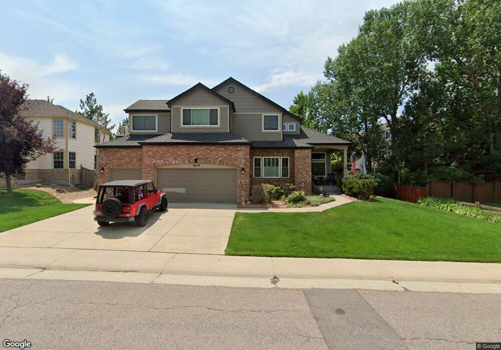
16118 Whitestone Dr Parker, CO 80134
Stonegate NeighborhoodEstimated Value: $743,000 - $817,000
5
Beds
3
Baths
3,562
Sq Ft
$217/Sq Ft
Est. Value
About This Home
This home is located at 16118 Whitestone Dr, Parker, CO 80134 and is currently estimated at $771,197, approximately $216 per square foot. 16118 Whitestone Dr is a home located in Douglas County with nearby schools including Pine Grove Elementary School, Sierra Middle School, and Chaparral High School.
Ownership History
Date
Name
Owned For
Owner Type
Purchase Details
Closed on
Oct 20, 2021
Sold by
Bergen Victor P and Bergen Victoria J
Bought by
Daly Elizabeth Forrest and Liebner Joseph Aaron
Current Estimated Value
Home Financials for this Owner
Home Financials are based on the most recent Mortgage that was taken out on this home.
Original Mortgage
$360,000
Outstanding Balance
$326,142
Interest Rate
2.8%
Mortgage Type
VA
Estimated Equity
$445,055
Purchase Details
Closed on
Jul 18, 2007
Sold by
Sirva Relocation Llc
Bought by
Bergen Victor P and Bergen Victoria J
Home Financials for this Owner
Home Financials are based on the most recent Mortgage that was taken out on this home.
Original Mortgage
$283,200
Interest Rate
6.54%
Mortgage Type
Unknown
Purchase Details
Closed on
Mar 13, 2001
Sold by
Douglass Michael W and Douglass Carrol L
Bought by
Stockham Timothy K and Stockham Amy L
Home Financials for this Owner
Home Financials are based on the most recent Mortgage that was taken out on this home.
Original Mortgage
$274,000
Interest Rate
6.81%
Purchase Details
Closed on
Dec 19, 1997
Sold by
Hamilton William J
Bought by
Douglass Michael W and Douglass Carrol L
Home Financials for this Owner
Home Financials are based on the most recent Mortgage that was taken out on this home.
Original Mortgage
$189,600
Interest Rate
7.07%
Purchase Details
Closed on
May 3, 1996
Sold by
Hamilton Rebecca L
Bought by
Hamilton William J
Home Financials for this Owner
Home Financials are based on the most recent Mortgage that was taken out on this home.
Original Mortgage
$171,500
Interest Rate
7.12%
Purchase Details
Closed on
Sep 27, 1994
Sold by
Falcon Partnership Ltd
Bought by
Hamilton William J and Hamilton Rebecca L
Home Financials for this Owner
Home Financials are based on the most recent Mortgage that was taken out on this home.
Original Mortgage
$175,000
Interest Rate
8.45%
Purchase Details
Closed on
Nov 30, 1993
Sold by
Stonegate Dev Inc
Bought by
Falcon Partnership Ltd
Create a Home Valuation Report for This Property
The Home Valuation Report is an in-depth analysis detailing your home's value as well as a comparison with similar homes in the area
Home Values in the Area
Average Home Value in this Area
Purchase History
| Date | Buyer | Sale Price | Title Company |
|---|---|---|---|
| Daly Elizabeth Forrest | $705,600 | Land Title Guarantee Company | |
| Bergen Victor P | $354,000 | Stewart Title Of Colorado | |
| Sirva Relocation Llc | $354,000 | None Available | |
| Stockham Timothy K | $342,500 | -- | |
| Douglass Michael W | $237,000 | -- | |
| Hamilton William J | -- | -- | |
| Hamilton William J | $225,000 | Land Title | |
| Falcon Partnership Ltd | $320,300 | -- |
Source: Public Records
Mortgage History
| Date | Status | Borrower | Loan Amount |
|---|---|---|---|
| Open | Daly Elizabeth Forrest | $360,000 | |
| Previous Owner | Bergen Victor P | $283,200 | |
| Previous Owner | Stockham Timothy K | $274,000 | |
| Previous Owner | Douglass Michael W | $189,600 | |
| Previous Owner | Hamilton William J | $171,500 | |
| Previous Owner | Hamilton William J | $175,000 |
Source: Public Records
Tax History
| Year | Tax Paid | Tax Assessment Tax Assessment Total Assessment is a certain percentage of the fair market value that is determined by local assessors to be the total taxable value of land and additions on the property. | Land | Improvement |
|---|---|---|---|---|
| 2025 | $4,906 | $43,530 | $10,610 | $32,920 |
| 2024 | $4,906 | $56,190 | $9,720 | $46,470 |
| 2023 | $4,948 | $56,190 | $9,720 | $46,470 |
| 2022 | $3,413 | $37,870 | $6,540 | $31,330 |
| 2021 | $4,299 | $37,870 | $6,540 | $31,330 |
| 2020 | $4,256 | $38,440 | $7,140 | $31,300 |
| 2019 | $4,153 | $38,440 | $7,140 | $31,300 |
| 2018 | $3,771 | $34,430 | $6,450 | $27,980 |
| 2017 | $3,556 | $34,430 | $6,450 | $27,980 |
| 2016 | $3,577 | $34,090 | $5,570 | $28,520 |
| 2015 | $3,646 | $34,090 | $5,570 | $28,520 |
| 2014 | $3,366 | $28,370 | $5,410 | $22,960 |
Source: Public Records
Map
Nearby Homes
- 10553 Stonemeadow Dr
- 16230 Martingale Dr
- 16351 Parkside Dr
- 16160 Martingale Dr
- 16224 Quarry Hill Dr
- 16116 Martingale Dr
- 10857 Tundra Top Dr
- 15362 Foxglove Ct
- 10873 Tundra Top Dr
- 10874 Tundra Top Dr
- 10549 Winterflower Way
- 10890 Tundra Top Dr
- 10776 Tomboy Dr
- 10772 Tomboy Dr
- 10912 Snowdon St
- 10773 Tomboy Dr
- 15733 Mccauley Dr
- 10130 Lodestone Way
- 10730 Tomboy Dr
- 10734 Tomboy Dr
- 16138 Whitestone Dr
- 16081 Hollyridge Dr
- 16101 Hollyridge Dr
- 16121 Hollyridge Dr
- 16117 Whitestone Dr
- 16137 Whitestone Dr
- 16097 Whitestone Dr
- 16061 Hollyridge Dr
- 16141 Hollyridge Dr
- 16077 Whitestone Dr
- 16057 Whitestone Dr
- 16161 Hollyridge Dr
- 16178 Whitestone Dr
- 16082 Hollyridge Dr
- 16102 Hollyridge Dr
- 16022 Hollyridge Dr
- 16062 Hollyridge Dr
- 16122 Hollyridge Dr
- 16037 Whitestone Dr
- 16042 Hollyridge Dr
Your Personal Tour Guide
Ask me questions while you tour the home.