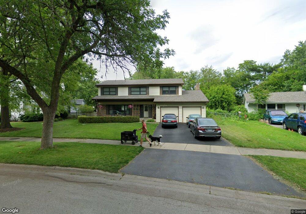
1616 Redpoll Ct Naperville, IL 60565
Maple Brook NeighborhoodEstimated Value: $540,000 - $633,000
Studio
1
Bath
2,368
Sq Ft
$242/Sq Ft
Est. Value
About This Home
This home is located at 1616 Redpoll Ct, Naperville, IL 60565 and is currently estimated at $573,309, approximately $242 per square foot. 1616 Redpoll Ct is a home located in DuPage County with nearby schools including Maplebrook Elementary School, Lincoln Jr. High School, and Naperville Central High School.
Ownership History
Date
Name
Owned For
Owner Type
Purchase Details
Closed on
Aug 14, 2002
Sold by
Schroder Ulf
Bought by
Whitlock Paul E and Whitlock Robyn M
Current Estimated Value
Home Financials for this Owner
Home Financials are based on the most recent Mortgage that was taken out on this home.
Original Mortgage
$257,000
Outstanding Balance
$109,371
Interest Rate
6.63%
Estimated Equity
$463,938
Purchase Details
Closed on
Sep 9, 1999
Sold by
Blagburn Robert G and Blagburn Mary Lou
Bought by
Schroder Ulf
Home Financials for this Owner
Home Financials are based on the most recent Mortgage that was taken out on this home.
Original Mortgage
$177,600
Interest Rate
5.12%
Create a Home Valuation Report for This Property
The Home Valuation Report is an in-depth analysis detailing your home's value as well as a comparison with similar homes in the area
Home Values in the Area
Average Home Value in this Area
Purchase History
| Date | Buyer | Sale Price | Title Company |
|---|---|---|---|
| Whitlock Paul E | $286,000 | -- | |
| Schroder Ulf | $222,000 | Premier Title |
Source: Public Records
Mortgage History
| Date | Status | Borrower | Loan Amount |
|---|---|---|---|
| Open | Whitlock Paul E | $257,000 | |
| Previous Owner | Schroder Ulf | $177,600 |
Source: Public Records
Tax History
| Year | Tax Paid | Tax Assessment Tax Assessment Total Assessment is a certain percentage of the fair market value that is determined by local assessors to be the total taxable value of land and additions on the property. | Land | Improvement |
|---|---|---|---|---|
| 2024 | $9,593 | $164,596 | $74,343 | $90,253 |
| 2023 | $9,241 | $150,220 | $67,850 | $82,370 |
| 2022 | $8,871 | $143,070 | $64,620 | $78,450 |
| 2021 | $8,546 | $137,660 | $62,180 | $75,480 |
| 2020 | $8,363 | $135,180 | $61,060 | $74,120 |
| 2019 | $8,118 | $129,330 | $58,420 | $70,910 |
| 2018 | $7,912 | $126,170 | $56,990 | $69,180 |
| 2017 | $7,752 | $121,920 | $55,070 | $66,850 |
| 2016 | $7,595 | $117,510 | $53,080 | $64,430 |
| 2015 | $7,544 | $110,660 | $49,990 | $60,670 |
| 2014 | $7,398 | $105,390 | $47,610 | $57,780 |
| 2013 | $7,287 | $105,640 | $47,720 | $57,920 |
Source: Public Records
Map
Nearby Homes
- 1751 S Washington St Unit 1
- 1754 S Washington St Unit 1754
- 124 E Bailey Rd Unit E
- 138 E Bailey Rd Unit M
- 144 E Bailey Rd Unit D
- 228 E Bailey Rd Unit F
- 264 E Bailey Rd Unit C
- 48 Starling Ln
- 1712 Coach Dr
- 510 Harlowe Ln Unit 2001C
- 1546 Treeline Ct Unit 405
- 1715 Amelia Ct
- 621 Bourbon Ct
- 381 Prairie Knoll Dr
- 627 Bourbon Ct
- 1449 Whitespire Ct Unit 5104
- 321 Carriage Hill Rd
- 517 Sheffield Rd
- 8S452 Bell Dr
- 307 Leeds Ct
- 1612 Redpoll Ct
- 1620 Redpoll Ct
- 16 W Bailey Rd
- 1617 Redpoll Ct
- 1624 Redpoll Ct
- 20 W Bailey Rd
- 1608 Redpoll Ct
- 12 W Bailey Rd
- 24 W Bailey Rd
- 1617 Swallow St
- 1609 Redpoll Ct
- 1625 Redpoll Ct
- 1628 Redpoll Ct
- 1621 Swallow St
- 1609 Swallow St
- 1620 Killdeer Dr
- 1625 Swallow St
- 1624 Killdeer Dr
- 1632 Redpoll Ct
- 1629 Swallow St
Your Personal Tour Guide
Ask me questions while you tour the home.