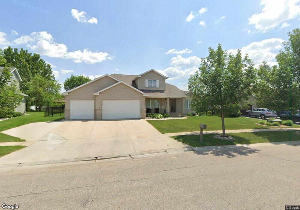
1619 6th St E West Fargo, ND 58078
Charleswood NeighborhoodEstimated Value: $566,000 - $599,783
6
Beds
4
Baths
3,572
Sq Ft
$163/Sq Ft
Est. Value
About This Home
This home is located at 1619 6th St E, West Fargo, ND 58078 and is currently estimated at $582,892, approximately $163 per square foot. 1619 6th St E is a home located in Cass County with nearby schools including South Elementary School, Cheney Middle School, and West Fargo High School.
Ownership History
Date
Name
Owned For
Owner Type
Purchase Details
Closed on
Jun 17, 2019
Sold by
Breidenbach Scott A and Breidenbach Paula M
Bought by
Alvine Travis and Alvine Beth
Current Estimated Value
Purchase Details
Closed on
Apr 16, 2012
Sold by
Hewitt Shawn and Hewitt Donal
Bought by
Breidenbach Scott A and Breidenbach Paula M
Create a Home Valuation Report for This Property
The Home Valuation Report is an in-depth analysis detailing your home's value as well as a comparison with similar homes in the area
Home Values in the Area
Average Home Value in this Area
Purchase History
| Date | Buyer | Sale Price | Title Company |
|---|---|---|---|
| Alvine Travis | $400,000 | Title Co | |
| Breidenbach Scott A | -- | Trn Abstract And Title |
Source: Public Records
Tax History Compared to Growth
Tax History
| Year | Tax Paid | Tax Assessment Tax Assessment Total Assessment is a certain percentage of the fair market value that is determined by local assessors to be the total taxable value of land and additions on the property. | Land | Improvement |
|---|---|---|---|---|
| 2024 | $6,526 | $250,450 | $42,500 | $207,950 |
| 2023 | $6,510 | $229,450 | $42,500 | $186,950 |
| 2022 | $6,612 | $223,300 | $42,500 | $180,800 |
| 2021 | $6,203 | $200,350 | $35,000 | $165,350 |
| 2020 | $5,817 | $193,900 | $35,000 | $158,900 |
| 2019 | $6,249 | $216,850 | $35,000 | $181,850 |
| 2018 | $5,885 | $213,100 | $35,000 | $178,100 |
| 2017 | $5,737 | $213,150 | $35,000 | $178,150 |
| 2016 | $5,135 | $209,150 | $35,000 | $174,150 |
| 2015 | $4,744 | $178,000 | $25,700 | $152,300 |
| 2014 | $4,511 | $166,350 | $25,700 | $140,650 |
| 2013 | $4,402 | $159,650 | $25,700 | $133,950 |
Source: Public Records
Map
Nearby Homes
- 631 15th Ave E
- 716 Northridge Way
- 724 Northridge Way
- 1809 Pentland St
- 727 14th Ave E
- 1811 7th St E
- 816 Lakeridge Place
- 1743 Cypress Way
- 338 13th Ave E
- 245 12th Ave E
- 670 13th Ave E
- 681 Pheasant Run
- 1633 3rd St W
- 232 15th Ave W
- 1730 12th St E
- 987 14th Ave E
- 1836 12th St E
- 1221 Cedar Way
- 437 10th Ave E
- 519 10th Ave E
- 1627 6th St E
- 1611 6th St E
- 631 Wyndemere Dr
- 627 Wyndemere Dr
- 635 Wyndemere Dr
- 623 Wyndemere Dr
- 1635 6th St E
- 1635 6th St E Unit Charleswood
- 639 Wyndemere Dr
- 1637 6th St E
- 643 Wyndemere Dr
- 1557 6th St E
- 1643 6th St E
- 647 Wyndemere Dr
- 630 Wyndemere Dr
- 634 Wyndemere Dr
- 626 Wyndemere Dr
- 701 Lakeridge Dr
- 1549 6th St E
- 638 Wyndemere Dr