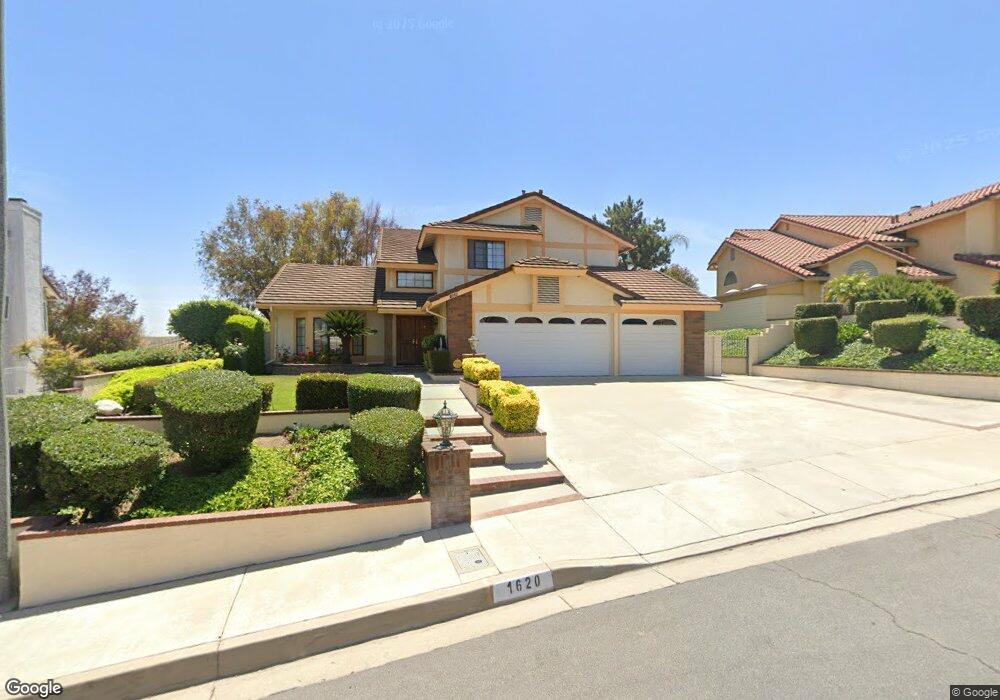
1620 Range Ct Diamond Bar, CA 91765
North Chino Hills NeighborhoodEstimated Value: $1,239,072 - $1,512,000
4
Beds
3
Baths
2,303
Sq Ft
$613/Sq Ft
Est. Value
About This Home
This home is located at 1620 Range Ct, Diamond Bar, CA 91765 and is currently estimated at $1,411,268, approximately $612 per square foot. 1620 Range Ct is a home located in San Bernardino County with nearby schools including Quail Summit Elementary School, Chaparral Middle School, and Diamond Bar High School.
Ownership History
Date
Name
Owned For
Owner Type
Purchase Details
Closed on
Jun 15, 2017
Sold by
Moulton Dennis and Moulton Elaine
Bought by
Moulton Dennis T and Moulton Elaine C
Current Estimated Value
Purchase Details
Closed on
Dec 10, 1995
Sold by
Memani David and Memani Liza
Bought by
Moulton Dennis and Moulton Elaine
Purchase Details
Closed on
Mar 3, 1995
Sold by
Western Financial Svgs Bank Fsb
Bought by
Nemani David and Nemani Liza
Home Financials for this Owner
Home Financials are based on the most recent Mortgage that was taken out on this home.
Original Mortgage
$220,000
Interest Rate
8.9%
Purchase Details
Closed on
Aug 19, 1994
Sold by
Nabi Mukhtar and Nabi Tasneem
Bought by
Western Financial Svgs Bank Fsb
Create a Home Valuation Report for This Property
The Home Valuation Report is an in-depth analysis detailing your home's value as well as a comparison with similar homes in the area
Home Values in the Area
Average Home Value in this Area
Purchase History
| Date | Buyer | Sale Price | Title Company |
|---|---|---|---|
| Moulton Dennis T | -- | None Available | |
| Moulton Dennis | -- | -- | |
| Nemani David | $275,000 | Chicago Title Insurance Co | |
| Western Financial Svgs Bank Fsb | $281,374 | Chicago Title |
Source: Public Records
Mortgage History
| Date | Status | Borrower | Loan Amount |
|---|---|---|---|
| Previous Owner | Nemani David | $220,000 |
Source: Public Records
Tax History
| Year | Tax Paid | Tax Assessment Tax Assessment Total Assessment is a certain percentage of the fair market value that is determined by local assessors to be the total taxable value of land and additions on the property. | Land | Improvement |
|---|---|---|---|---|
| 2025 | $6,428 | $464,187 | $137,874 | $326,313 |
| 2024 | $6,428 | $455,086 | $135,171 | $319,915 |
| 2023 | $6,273 | $446,164 | $132,521 | $313,643 |
| 2022 | $6,075 | $437,417 | $129,923 | $307,494 |
| 2021 | $5,747 | $428,841 | $127,376 | $301,465 |
| 2019 | $5,499 | $409,523 | $123,599 | $285,924 |
| 2018 | $5,277 | $401,494 | $121,176 | $280,318 |
| 2016 | $4,900 | $385,905 | $116,471 | $269,434 |
| 2015 | $4,872 | $380,109 | $114,722 | $265,387 |
| 2014 | $4,827 | $372,664 | $112,475 | $260,189 |
Source: Public Records
Map
Nearby Homes
- 24324 Knoll Ct
- 24303 Rimford Place
- 24215 Delta Dr
- 1202 Bramford Ct
- 1729 Derringer Ln
- 1755 Derringer Ln
- 2112 Indian Creek Rd
- 1925 Derringer Ln
- 1822 Diamond Knoll Ln
- 1126 Pebblewood Dr
- 2137 Derringer Ln
- 1511 Deer Crossing Dr
- 23419 Sandridge Rd
- 24301 Sunnycrest Ct
- 959 Whitecliff Dr
- 1122 Cleghorn Dr Unit A
- 23328 Forest Canyon Dr
- 23509 Ridge Line Rd
- 23640 Monument Canyon Dr Unit C
- 2182 Indian Creek Rd
Your Personal Tour Guide
Ask me questions while you tour the home.