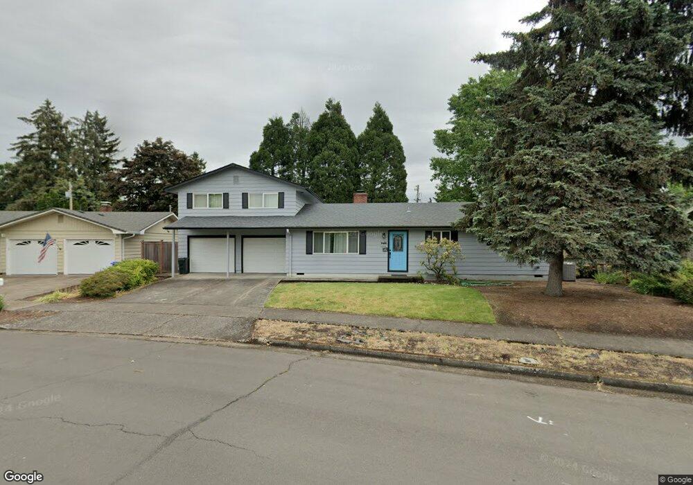
1635 Long Island Dr Eugene, OR 97401
Cal Young NeighborhoodEstimated Value: $542,000 - $572,000
3
Beds
2
Baths
1,951
Sq Ft
$285/Sq Ft
Est. Value
About This Home
This home is located at 1635 Long Island Dr, Eugene, OR 97401 and is currently estimated at $556,584, approximately $285 per square foot. 1635 Long Island Dr is a home located in Lane County with nearby schools including Willagillespie Elementary School, Monroe Middle School, and Sheldon High School.
Ownership History
Date
Name
Owned For
Owner Type
Purchase Details
Closed on
Feb 4, 2010
Sold by
Haro Jose Alberto
Bought by
Haro Alberto and Haro Geraldine Ann
Current Estimated Value
Purchase Details
Closed on
Oct 17, 2003
Sold by
March Nellie S
Bought by
Haro Jose Alberto
Home Financials for this Owner
Home Financials are based on the most recent Mortgage that was taken out on this home.
Original Mortgage
$194,820
Outstanding Balance
$91,370
Interest Rate
6.4%
Mortgage Type
VA
Estimated Equity
$465,214
Create a Home Valuation Report for This Property
The Home Valuation Report is an in-depth analysis detailing your home's value as well as a comparison with similar homes in the area
Home Values in the Area
Average Home Value in this Area
Purchase History
| Date | Buyer | Sale Price | Title Company |
|---|---|---|---|
| Haro Alberto | -- | Cascade Title Co | |
| Haro Jose Alberto | $191,000 | Cascade Title Co |
Source: Public Records
Mortgage History
| Date | Status | Borrower | Loan Amount |
|---|---|---|---|
| Open | Haro Jose Alberto | $194,820 |
Source: Public Records
Tax History Compared to Growth
Tax History
| Year | Tax Paid | Tax Assessment Tax Assessment Total Assessment is a certain percentage of the fair market value that is determined by local assessors to be the total taxable value of land and additions on the property. | Land | Improvement |
|---|---|---|---|---|
| 2025 | $5,430 | $278,678 | -- | -- |
| 2024 | $5,362 | $270,562 | -- | -- |
| 2023 | $5,362 | $262,682 | $0 | $0 |
| 2022 | $5,023 | $255,032 | $0 | $0 |
| 2021 | $4,718 | $247,604 | $0 | $0 |
| 2020 | $4,735 | $240,393 | $0 | $0 |
| 2019 | $4,573 | $233,392 | $0 | $0 |
| 2018 | $4,305 | $219,995 | $0 | $0 |
| 2017 | $4,112 | $219,995 | $0 | $0 |
| 2016 | $3,946 | $213,587 | $0 | $0 |
| 2015 | $3,821 | $207,366 | $0 | $0 |
| 2014 | $3,736 | $201,326 | $0 | $0 |
Source: Public Records
Map
Nearby Homes
- 1798 Carmel Ave
- 1637 Larkspur Loop
- 1632 Larkspur Loop
- 2055 Monterey Ln
- 1982 Shiloh St
- 1585 Farm House Dr
- 2133 Jeppesen Acres Rd
- 1500 Norkenzie Rd Unit 43
- 1261 Spyglass Dr
- 1750 Tabor St
- 1328 Spyglass Dr
- 1332 Jeppesen Ave
- 1641 Chasa St
- 863 Fairway View Dr
- 1254 Rio Glen Dr
- 410 Spyglass Dr
- 2065 Providence St
- 2190 Providence St
- 2132 Willona Dr
- 2134 Willona Dr
- 1655 Long Island Dr
- 1895 Carmel Ave
- 1625 Long Island Dr
- 1622 Colby Ct
- 1616 Colby Ct
- 1675 Long Island Dr
- 1638 Colby Ct
- 1909 Carmel Ave
- 1650 Long Island Dr
- 1630 Long Island Dr
- 1670 Long Island Dr
- 1685 Long Island Dr
- 1649 Colby Ct
- 1910 Myers Rd
- 1590 Diane St
- 1615 Colby Ct
- 1860 Carmel Ave
- 1623 Colby Ct
- 1775 Carmel Ave
- 1637 Colby Ct