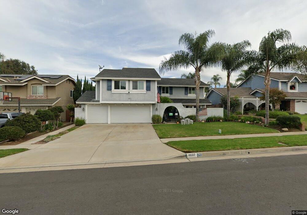
1637 Sutter Ln Corona, CA 92879
Central Corona NeighborhoodEstimated Value: $703,000 - $801,466
4
Beds
3
Baths
2,318
Sq Ft
$327/Sq Ft
Est. Value
About This Home
This home is located at 1637 Sutter Ln, Corona, CA 92879 and is currently estimated at $756,867, approximately $326 per square foot. 1637 Sutter Ln is a home located in Riverside County with nearby schools including Garretson Elementary School, Auburndale Intermediate, and Centennial High School.
Ownership History
Date
Name
Owned For
Owner Type
Purchase Details
Closed on
Aug 28, 2020
Sold by
Paxton Leonidas Earl and Paxton Karyn Lynn
Bought by
Paxton Leonidas Earl and Paxton Karyn Lynn
Current Estimated Value
Home Financials for this Owner
Home Financials are based on the most recent Mortgage that was taken out on this home.
Original Mortgage
$320,508
Interest Rate
3%
Mortgage Type
New Conventional
Purchase Details
Closed on
Aug 15, 2020
Sold by
Paxton Leonidas Earl and Paxton Karyn Lynn
Bought by
Paxton Leonidas Earl and Paxton Karyn Lynn
Home Financials for this Owner
Home Financials are based on the most recent Mortgage that was taken out on this home.
Original Mortgage
$320,508
Interest Rate
3%
Mortgage Type
New Conventional
Purchase Details
Closed on
Nov 11, 2013
Sold by
Paxton Leonidas E and Paxton Karyn Lynn
Bought by
Paxton Trust
Create a Home Valuation Report for This Property
The Home Valuation Report is an in-depth analysis detailing your home's value as well as a comparison with similar homes in the area
Home Values in the Area
Average Home Value in this Area
Purchase History
| Date | Buyer | Sale Price | Title Company |
|---|---|---|---|
| Paxton Leonidas Earl | -- | Wfg National Title Company | |
| Paxton Leonidas Earl | -- | Wfg National Title Company | |
| Paxton Trust | -- | None Available |
Source: Public Records
Mortgage History
| Date | Status | Borrower | Loan Amount |
|---|---|---|---|
| Closed | Paxton Leonidas Earl | $320,508 |
Source: Public Records
Tax History
| Year | Tax Paid | Tax Assessment Tax Assessment Total Assessment is a certain percentage of the fair market value that is determined by local assessors to be the total taxable value of land and additions on the property. | Land | Improvement |
|---|---|---|---|---|
| 2025 | $3,431 | $316,734 | $87,834 | $228,900 |
| 2023 | $3,431 | $304,436 | $84,424 | $220,012 |
| 2022 | $6,125 | $298,468 | $82,769 | $215,699 |
| 2021 | $6,058 | $292,617 | $81,147 | $211,470 |
| 2020 | $5,977 | $289,617 | $80,315 | $209,302 |
| 2019 | $5,901 | $283,940 | $78,741 | $205,199 |
| 2018 | $5,825 | $278,374 | $77,198 | $201,176 |
| 2017 | $5,729 | $272,917 | $75,685 | $197,232 |
| 2016 | $5,699 | $267,566 | $74,201 | $193,365 |
| 2015 | $5,643 | $263,549 | $73,088 | $190,461 |
| 2014 | $2,793 | $258,388 | $71,657 | $186,731 |
Source: Public Records
Map
Nearby Homes
- 1925 S Starfire Ave
- 1710 Garretson Ave
- 860 Tangerine St
- 883 Tangerine St
- 2102 Beatrice Dr
- 395 E Monterey Rd
- 1740 Forum Way Unit C
- 1761 Forum Way Unit D
- 938 Ford St
- 1171 Stone Pine Ln Unit C
- 929 Fullerton Ave
- 1138 Acacia St
- 1511 S Main St
- 1153 E Grand Blvd
- 1550 Rimpau Ave Unit 37
- 1550 Rimpau Ave Unit 132
- 1550 Rimpau Ave Unit 125
- 1550 Rimpau Ave Unit 138
- 1550 Rimpau Ave Unit 20
- 1550 Rimpau Ave Unit 52
Your Personal Tour Guide
Ask me questions while you tour the home.