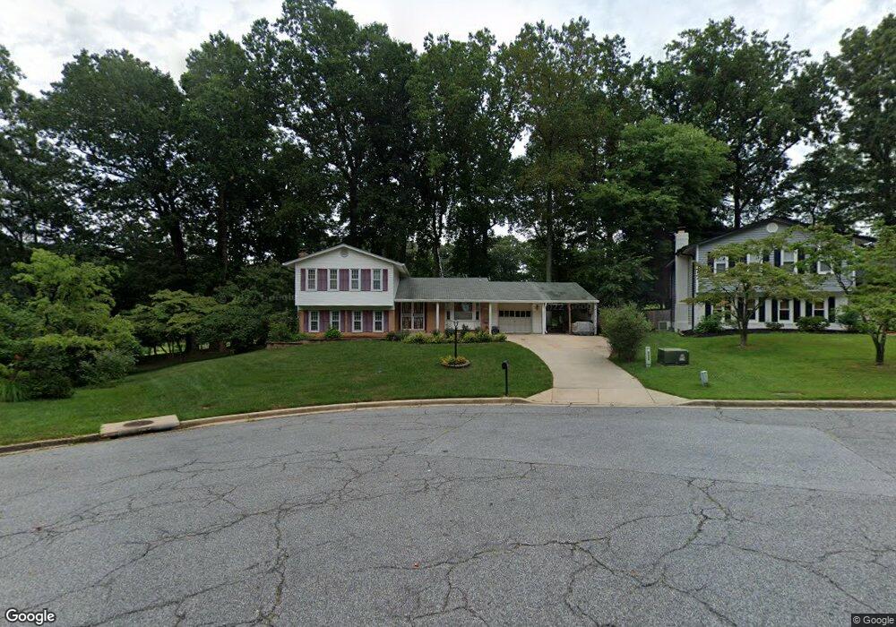
16405 Gales St Laurel, MD 20707
West Laurel NeighborhoodEstimated Value: $477,053 - $534,000
Studio
3
Baths
1,967
Sq Ft
$260/Sq Ft
Est. Value
About This Home
This home is located at 16405 Gales St, Laurel, MD 20707 and is currently estimated at $511,763, approximately $260 per square foot. 16405 Gales St is a home located in Prince George's County with nearby schools including Bond Mill Elementary, Martin Luther King Jr. Middle School, and Laurel High School.
Ownership History
Date
Name
Owned For
Owner Type
Purchase Details
Closed on
Mar 8, 2005
Sold by
Danihelmary Trustee
Bought by
Danihel Mark S
Current Estimated Value
Purchase Details
Closed on
Jan 29, 1997
Sold by
Danihel Kathleen M
Bought by
Danihelmary Trustee
Purchase Details
Closed on
Dec 16, 1996
Sold by
Danihelkathleen M Trustee
Bought by
Danihel Kathleen M
Create a Home Valuation Report for This Property
The Home Valuation Report is an in-depth analysis detailing your home's value as well as a comparison with similar homes in the area
Home Values in the Area
Average Home Value in this Area
Purchase History
| Date | Buyer | Sale Price | Title Company |
|---|---|---|---|
| Danihel Mark S | -- | -- | |
| Danihelmary Trustee | -- | -- | |
| Danihel Kathleen M | -- | -- |
Source: Public Records
Tax History
| Year | Tax Paid | Tax Assessment Tax Assessment Total Assessment is a certain percentage of the fair market value that is determined by local assessors to be the total taxable value of land and additions on the property. | Land | Improvement |
|---|---|---|---|---|
| 2025 | $5,069 | $423,900 | $141,600 | $282,300 |
| 2024 | $5,069 | $411,867 | -- | -- |
| 2023 | $4,932 | $399,833 | $0 | $0 |
| 2022 | $3,338 | $387,800 | $101,600 | $286,200 |
| 2021 | $2,961 | $368,600 | $0 | $0 |
| 2020 | $2,987 | $349,400 | $0 | $0 |
| 2019 | $4,284 | $330,200 | $100,800 | $229,400 |
| 2018 | $1,941 | $314,300 | $0 | $0 |
| 2017 | $4,019 | $298,400 | $0 | $0 |
| 2016 | -- | $282,500 | $0 | $0 |
| 2015 | $3,428 | $274,033 | $0 | $0 |
| 2014 | $3,428 | $265,567 | $0 | $0 |
Source: Public Records
Map
Nearby Homes
- 7106 Donston Dr
- 7019 Redmiles Rd
- 7209 Brooklyn Bridge Rd
- 7004 Fitzpatrick Dr
- 16140 Kenny Rd
- 6003 Windham Rd
- 7019 Fitzpatrick Dr
- 15611 Riding Stable Rd
- 14005 Barkham Ct
- 7002 Scotch Dr
- 6918 Scotch Dr
- 15712 Dorset Rd Unit 104
- 15708 Dorset Rd Unit 203
- 15708 Dorset Rd Unit 202
- 15706 Dorset Rd Unit 102
- 7616 Woodbine Dr
- 15603 Dorset Rd Unit 101
- 15743 Millbrook Ln
- 10681 Old Bond Mill Rd
- 15781 Haynes Rd
- 16403 Gales St
- 16406 Gales St
- 16401 Gales St
- 16404 Gales St
- 16402 Gales St
- 6416 Mccahill Dr
- 6411 Forest Mill Ln
- 6410 Mccahill Dr
- 6409 Forest Mill Ln
- 6407 Forest Mill Ln
- 6408 Mccahill Dr
- 6405 Forest Mill Ln
- 6413 Mccahill Dr
- 6601 Carleton Ct
- 6412 Forest Mill Ln
- 6600 Carleton Ct
- 6415 Mccahill Dr
- 6403 Forest Mill Ln
- 16310 Gales St
- 6600 Mccahill Terrace
Your Personal Tour Guide
Ask me questions while you tour the home.