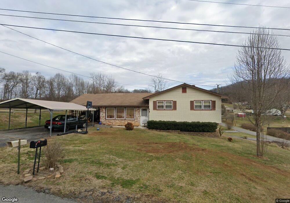
166 Forrest Rd Fall Branch, TN 37656
Estimated Value: $271,378 - $317,000
3
Beds
2
Baths
1,855
Sq Ft
$156/Sq Ft
Est. Value
About This Home
This home is located at 166 Forrest Rd, Fall Branch, TN 37656 and is currently estimated at $288,845, approximately $155 per square foot. 166 Forrest Rd is a home located in Washington County with nearby schools including Fall Branch Elementary School and Daniel Boone High School.
Ownership History
Date
Name
Owned For
Owner Type
Purchase Details
Closed on
Mar 10, 2009
Sold by
Shackelford Robert W
Bought by
Kennedy James D
Current Estimated Value
Home Financials for this Owner
Home Financials are based on the most recent Mortgage that was taken out on this home.
Original Mortgage
$130,800
Outstanding Balance
$83,171
Interest Rate
5.13%
Mortgage Type
VA
Estimated Equity
$205,674
Purchase Details
Closed on
Mar 27, 1992
Bought by
Shackleford Robert W & Dianna %1St Tn Bank Na
Create a Home Valuation Report for This Property
The Home Valuation Report is an in-depth analysis detailing your home's value as well as a comparison with similar homes in the area
Home Values in the Area
Average Home Value in this Area
Purchase History
| Date | Buyer | Sale Price | Title Company |
|---|---|---|---|
| Kennedy James D | $128,950 | -- | |
| Shackleford Robert W & Dianna %1St Tn Bank Na | $60,000 | -- |
Source: Public Records
Mortgage History
| Date | Status | Borrower | Loan Amount |
|---|---|---|---|
| Open | Shackleford Robert W & Dianna %1St Tn Bank Na | $130,800 |
Source: Public Records
Tax History Compared to Growth
Tax History
| Year | Tax Paid | Tax Assessment Tax Assessment Total Assessment is a certain percentage of the fair market value that is determined by local assessors to be the total taxable value of land and additions on the property. | Land | Improvement |
|---|---|---|---|---|
| 2024 | $853 | $49,875 | $3,825 | $46,050 |
| 2022 | $627 | $29,150 | $3,125 | $26,025 |
| 2021 | $627 | $29,150 | $3,125 | $26,025 |
| 2020 | $627 | $29,150 | $3,125 | $26,025 |
| 2019 | $647 | $29,150 | $3,125 | $26,025 |
| 2018 | $647 | $27,175 | $3,125 | $24,050 |
| 2017 | $647 | $27,175 | $3,125 | $24,050 |
| 2016 | $647 | $27,175 | $3,125 | $24,050 |
| 2015 | $538 | $27,175 | $3,125 | $24,050 |
| 2014 | $538 | $27,175 | $3,125 | $24,050 |
Source: Public Records
Map
Nearby Homes
- 160 Forrest Rd
- 2145 Tennessee 93
- 1625 Highway 93
- 1415 Highway 93
- 255 Bank Dr
- 40 Spring Ln
- Tbd Oak Glen Cir
- 106 Davis Rd
- Tr 1 Joe R McCrary Rd
- 825 Old Blairs Gap Rd
- 176 Moulton Rd
- 704 Church Hill Dr
- 263 Moulton Rd
- 901 Old Blairs Gap Rd
- 1340 Ryan Rd
- 338 Citation Cir
- 480 Fordtown Rd
- 206 Hialeah Dr
- 201 Derby Dr
- 115 Belmont Ct