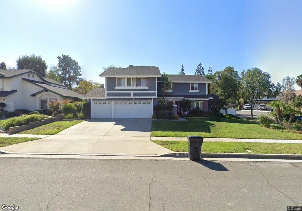
1660 Sutter Ln Corona, CA 92879
Central Corona NeighborhoodEstimated Value: $725,000 - $814,804
4
Beds
3
Baths
2,318
Sq Ft
$332/Sq Ft
Est. Value
About This Home
This home is located at 1660 Sutter Ln, Corona, CA 92879 and is currently estimated at $769,201, approximately $331 per square foot. 1660 Sutter Ln is a home located in Riverside County with nearby schools including Garretson Elementary School, Auburndale Intermediate, and Centennial High School.
Ownership History
Date
Name
Owned For
Owner Type
Purchase Details
Closed on
Aug 3, 2006
Sold by
Smith Ronald C and Smith Debra J
Bought by
Smith Ronald C and Smith Debra J
Current Estimated Value
Home Financials for this Owner
Home Financials are based on the most recent Mortgage that was taken out on this home.
Original Mortgage
$210,000
Outstanding Balance
$125,669
Interest Rate
6.7%
Mortgage Type
Stand Alone Refi Refinance Of Original Loan
Estimated Equity
$643,532
Purchase Details
Closed on
Aug 16, 1994
Sold by
Blackford Robert L and Geraldine Blackford B
Bought by
Smith Ronald C and Smith Debra J
Home Financials for this Owner
Home Financials are based on the most recent Mortgage that was taken out on this home.
Original Mortgage
$70,000
Interest Rate
8.92%
Mortgage Type
Purchase Money Mortgage
Create a Home Valuation Report for This Property
The Home Valuation Report is an in-depth analysis detailing your home's value as well as a comparison with similar homes in the area
Home Values in the Area
Average Home Value in this Area
Purchase History
| Date | Buyer | Sale Price | Title Company |
|---|---|---|---|
| Smith Ronald C | -- | Financial Title Company | |
| Smith Ronald C | $195,000 | Continental Lawyers Title Co |
Source: Public Records
Mortgage History
| Date | Status | Borrower | Loan Amount |
|---|---|---|---|
| Open | Smith Ronald C | $210,000 | |
| Previous Owner | Smith Ronald C | $70,000 |
Source: Public Records
Tax History
| Year | Tax Paid | Tax Assessment Tax Assessment Total Assessment is a certain percentage of the fair market value that is determined by local assessors to be the total taxable value of land and additions on the property. | Land | Improvement |
|---|---|---|---|---|
| 2025 | $3,592 | $331,527 | $92,365 | $239,162 |
| 2023 | $3,592 | $318,655 | $88,779 | $229,876 |
| 2022 | $3,476 | $312,408 | $87,039 | $225,369 |
| 2021 | $3,406 | $306,283 | $85,333 | $220,950 |
| 2020 | $3,368 | $303,144 | $84,459 | $218,685 |
| 2019 | $3,249 | $293,601 | $82,803 | $210,798 |
| 2018 | $3,175 | $287,845 | $81,181 | $206,664 |
| 2017 | $3,097 | $282,202 | $79,590 | $202,612 |
| 2016 | $3,065 | $276,670 | $78,030 | $198,640 |
| 2015 | $2,998 | $272,516 | $76,859 | $195,657 |
| 2014 | $2,888 | $267,179 | $75,354 | $191,825 |
Source: Public Records
Map
Nearby Homes
- 1925 S Starfire Ave
- 1710 Garretson Ave
- 860 Tangerine St
- 883 Tangerine St
- 2102 Beatrice Dr
- 395 E Monterey Rd
- 1740 Forum Way Unit C
- 1761 Forum Way Unit D
- 938 Ford St
- 1171 Stone Pine Ln Unit C
- 1511 S Main St
- 929 Fullerton Ave
- 1138 Acacia St
- 1153 E Grand Blvd
- 1550 Rimpau Ave Unit 37
- 1550 Rimpau Ave Unit 132
- 1550 Rimpau Ave Unit 125
- 1550 Rimpau Ave Unit 138
- 1550 Rimpau Ave Unit 20
- 1550 Rimpau Ave Unit 52
Your Personal Tour Guide
Ask me questions while you tour the home.