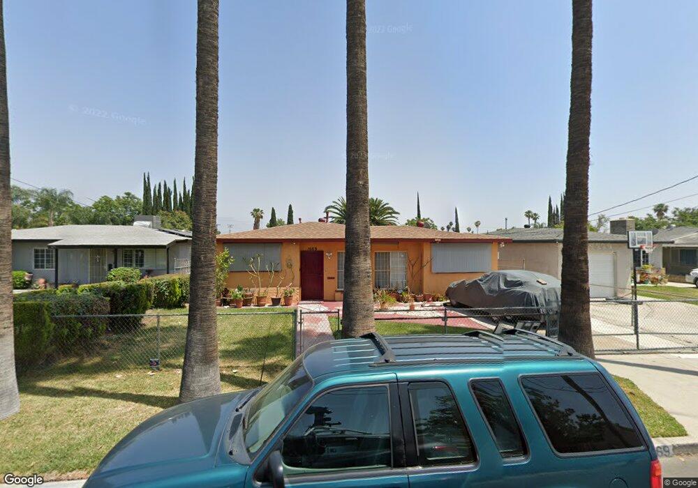
1669 Davidson Ave San Bernardino, CA 92411
Roosevelt NeighborhoodEstimated Value: $385,540 - $401,000
2
Beds
1
Bath
804
Sq Ft
$491/Sq Ft
Est. Value
About This Home
This home is located at 1669 Davidson Ave, San Bernardino, CA 92411 and is currently estimated at $394,885, approximately $491 per square foot. 1669 Davidson Ave is a home located in San Bernardino County with nearby schools including Roosevelt Elementary School, Dr. Martin Luther King Jr. Middle School, and San Bernardino High School.
Ownership History
Date
Name
Owned For
Owner Type
Purchase Details
Closed on
Dec 8, 2020
Sold by
Brooks Lucille
Bought by
Brooks Lucille and Brooks Rodney Jefferson
Current Estimated Value
Purchase Details
Closed on
Jul 20, 2016
Sold by
Lee Lucille Brooks and Lucille Brooks Trust
Bought by
Brooks Lucille
Purchase Details
Closed on
Aug 1, 2008
Sold by
Brooks Lucille
Bought by
Brooks Lucille and The Lucille Brooks Trust
Create a Home Valuation Report for This Property
The Home Valuation Report is an in-depth analysis detailing your home's value as well as a comparison with similar homes in the area
Home Values in the Area
Average Home Value in this Area
Purchase History
| Date | Buyer | Sale Price | Title Company |
|---|---|---|---|
| Brooks Lucille | -- | None Listed On Document | |
| Brooks Lucille | -- | None Available | |
| Brooks Lucille | -- | Accommodation | |
| Brooks Lucille | -- | Accommodation |
Source: Public Records
Tax History Compared to Growth
Tax History
| Year | Tax Paid | Tax Assessment Tax Assessment Total Assessment is a certain percentage of the fair market value that is determined by local assessors to be the total taxable value of land and additions on the property. | Land | Improvement |
|---|---|---|---|---|
| 2025 | $1,149 | $86,610 | $17,333 | $69,277 |
| 2024 | $1,149 | $84,912 | $16,993 | $67,919 |
| 2023 | $1,118 | $83,247 | $16,660 | $66,587 |
| 2022 | $1,115 | $81,614 | $16,333 | $65,281 |
| 2021 | $1,111 | $80,014 | $16,013 | $64,001 |
| 2020 | $1,109 | $79,194 | $15,849 | $63,345 |
| 2019 | $1,078 | $77,641 | $15,538 | $62,103 |
| 2018 | $1,066 | $76,118 | $15,233 | $60,885 |
| 2017 | $1,031 | $74,625 | $14,934 | $59,691 |
| 2016 | $999 | $73,162 | $14,641 | $58,521 |
| 2015 | $865 | $72,063 | $14,421 | $57,642 |
| 2014 | $839 | $70,652 | $14,139 | $56,513 |
Source: Public Records
Map
Nearby Homes
- 1963 Turrill Ave
- 1708 N Mount Vernon Ave
- 1190 W 14th St
- 1950 N Mount Vernon Ave
- 994 Magnolia Ave
- 1364 W 15th St
- 1424 W 16th St
- 964 W 14th St
- 2113 Herrington Ave N
- 0 N Mt Vernon Ave Unit OC25230729
- 1278 Perris St
- 694 N Mount Vernon Ave
- 1263 N Mount Vernon Ave
- 1341 N Pico Ave
- 1286 W 23rd St
- 1256 W Base Line St
- 1298 W 23rd St
- 1263 W Baseline St
- 738 W 18th St Unit 2
- 1528 W Virginia St
- 1663 Davidson Ave
- 1675 Davidson Ave
- 1681 Davidson Ave
- 1657 Davidson Ave
- 1165 W Trenton St
- 1649 Davidson Ave
- 1166 W Trenton St
- 1689 Davidson Ave
- 1173 W Trenton St
- 1643 Davidson Ave
- 1174 W Trenton St
- 1166 Cummings Way
- 1161 W 17th St
- 1153 W 17th St
- 1145 W 17th St
- 1169 W 17th St
- 1181 W Trenton St
- 1174 Cummings Way
- 1182 W Trenton St
- 1137 W 17th St