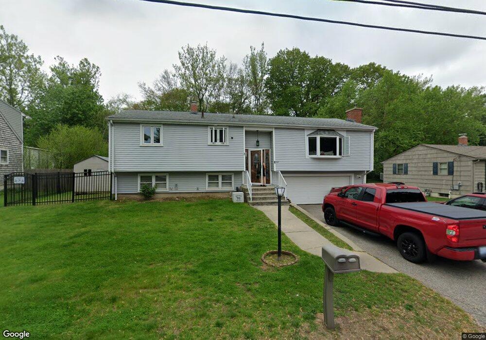
167 Pheasant Dr Cranston, RI 02920
Thornton NeighborhoodEstimated Value: $468,000 - $531,000
3
Beds
2
Baths
1,662
Sq Ft
$296/Sq Ft
Est. Value
About This Home
This home is located at 167 Pheasant Dr, Cranston, RI 02920 and is currently estimated at $491,453, approximately $295 per square foot. 167 Pheasant Dr is a home located in Providence County with nearby schools including Stone Hill School, Western Hills Middle School, and Cranston High School West.
Ownership History
Date
Name
Owned For
Owner Type
Purchase Details
Closed on
Mar 30, 2004
Sold by
Sczerbinski Joseph and Sczerbinski Carolyn
Bought by
Constant Paul
Current Estimated Value
Purchase Details
Closed on
Apr 25, 1990
Sold by
Sczerbinski Joseph
Bought by
Sczerbinski Joseph V
Create a Home Valuation Report for This Property
The Home Valuation Report is an in-depth analysis detailing your home's value as well as a comparison with similar homes in the area
Home Values in the Area
Average Home Value in this Area
Purchase History
| Date | Buyer | Sale Price | Title Company |
|---|---|---|---|
| Constant Paul | $237,000 | -- | |
| Sczerbinski Joseph V | $114,000 | -- |
Source: Public Records
Mortgage History
| Date | Status | Borrower | Loan Amount |
|---|---|---|---|
| Open | Sczerbinski Joseph V | $205,000 | |
| Closed | Sczerbinski Joseph V | $200,000 |
Source: Public Records
Tax History Compared to Growth
Tax History
| Year | Tax Paid | Tax Assessment Tax Assessment Total Assessment is a certain percentage of the fair market value that is determined by local assessors to be the total taxable value of land and additions on the property. | Land | Improvement |
|---|---|---|---|---|
| 2025 | $5,978 | $430,700 | $128,800 | $301,900 |
| 2024 | $5,862 | $430,700 | $128,800 | $301,900 |
| 2023 | $5,307 | $280,800 | $92,500 | $188,300 |
| 2022 | $5,198 | $280,800 | $92,500 | $188,300 |
| 2021 | $4,788 | $266,000 | $92,500 | $173,500 |
| 2020 | $4,976 | $239,600 | $92,500 | $147,100 |
| 2019 | $4,976 | $239,600 | $92,500 | $147,100 |
| 2018 | $4,861 | $239,600 | $92,500 | $147,100 |
| 2017 | $4,751 | $207,100 | $74,000 | $133,100 |
| 2016 | $4,649 | $207,100 | $74,000 | $133,100 |
| 2015 | $4,649 | $207,100 | $74,000 | $133,100 |
| 2014 | $4,479 | $196,100 | $74,000 | $122,100 |
Source: Public Records
Map
Nearby Homes
- 20 Wild Berry Dr
- 11 Red Robin Rd
- 17 Woodview Dr
- 134 Lake Garden Dr
- 26 Scituate Farms Dr
- 435 Scituate Ave
- 51 Stone Dr
- 95 Amy Dr
- 20 Doreen Ct
- 118 Westfield Dr
- 105 Amy Dr
- 30 Dutchess Dr
- 26 Rachela St
- 60 Harmony St
- 41 Yeoman Ave
- 1603 Plainfield Pike Unit D5
- 1603 Plainfield Pike Unit E2
- 27 Nardolillo St
- 25 Loomis St
- 56 Scituate Ave
- 159 Pheasant Dr
- 173 Pheasant Dr
- 153 Pheasant Dr
- 164 Pheasant Dr
- 5 Starling Dr
- 180 Pheasant Dr
- 185 Pheasant Dr
- 147 Pheasant Dr
- 115 Eagle Rd
- 101 Eagle Rd
- 105 Eagle Rd
- 125 Eagle Rd
- 15 Starling Dr
- 141 Pheasant Dr
- 191 Pheasant Dr
- 6 Starling Dr
- 196 Pheasant Dr
- 133 Pheasant Dr
- 197 Pheasant Dr
- 136 Pheasant Dr