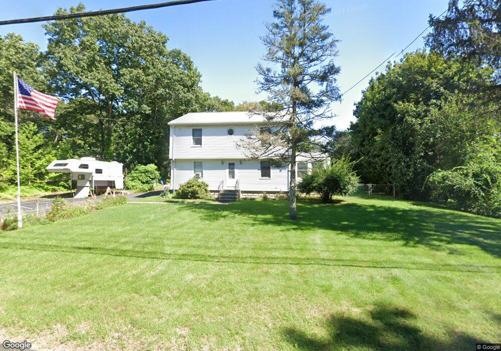
167 Thurston St Wrentham, MA 02093
Estimated Value: $622,000 - $646,000
4
Beds
2
Baths
1,870
Sq Ft
$339/Sq Ft
Est. Value
About This Home
This home is located at 167 Thurston St, Wrentham, MA 02093 and is currently estimated at $633,841, approximately $338 per square foot. 167 Thurston St is a home located in Norfolk County with nearby schools including Delaney Elementary School, Charles E Roderick, and The Sage School.
Ownership History
Date
Name
Owned For
Owner Type
Purchase Details
Closed on
Mar 6, 1973
Bought by
Bruneau Paul J and Bruneau Ann M
Current Estimated Value
Create a Home Valuation Report for This Property
The Home Valuation Report is an in-depth analysis detailing your home's value as well as a comparison with similar homes in the area
Home Values in the Area
Average Home Value in this Area
Purchase History
| Date | Buyer | Sale Price | Title Company |
|---|---|---|---|
| Bruneau Paul J | -- | -- |
Source: Public Records
Mortgage History
| Date | Status | Borrower | Loan Amount |
|---|---|---|---|
| Closed | Bruneau Paul J | $60,000 | |
| Closed | Bruneau Paul J | $48,000 |
Source: Public Records
Tax History Compared to Growth
Tax History
| Year | Tax Paid | Tax Assessment Tax Assessment Total Assessment is a certain percentage of the fair market value that is determined by local assessors to be the total taxable value of land and additions on the property. | Land | Improvement |
|---|---|---|---|---|
| 2025 | $6,012 | $518,700 | $247,700 | $271,000 |
| 2024 | $5,912 | $492,700 | $247,700 | $245,000 |
| 2023 | $5,608 | $444,400 | $225,200 | $219,200 |
| 2022 | $5,386 | $394,000 | $202,700 | $191,300 |
| 2021 | $5,051 | $359,000 | $181,100 | $177,900 |
| 2020 | $5,013 | $351,800 | $165,200 | $186,600 |
| 2019 | $4,651 | $329,400 | $150,200 | $179,200 |
| 2018 | $4,702 | $330,200 | $150,300 | $179,900 |
| 2017 | $4,453 | $312,500 | $147,400 | $165,100 |
| 2016 | $4,358 | $305,200 | $143,200 | $162,000 |
| 2015 | $4,223 | $281,900 | $137,600 | $144,300 |
| 2014 | $4,166 | $272,100 | $132,400 | $139,700 |
Source: Public Records
Map
Nearby Homes
- 362 East St
- 65 Pond St
- 120 Hawes St
- 483 Thurston St
- 1 Lorraine Metcalf Dr
- 319 Taunton St
- 270 Dedham St
- 10 Nature View Dr
- 15 Nature View Dr
- 25 Foxboro Rd
- 11 Earle Stewart Ln
- 131 Creek St Unit 7
- 11 Goodwin Dr
- Lot 3 - 14 Earle Stewart Ln
- Lot 1 - Blueberry 2 Car Plan at King Philip Estates
- Lot 8 - Blueberry 2 Car Plan at King Philip Estates
- Lot 5 - Hughes 2 car Plan at King Philip Estates
- Lot 6 - Blueberry 3 Car Plan at King Philip Estates
- Lot 2 - Camden 2 Car Plan at King Philip Estates
- Lot 7 - Cedar Plan at King Philip Estates