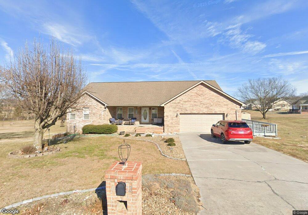
1672 Sams Dr Unit 37 Dandridge, TN 37725
Estimated Value: $477,000 - $596,000
--
Bed
3
Baths
1,958
Sq Ft
$279/Sq Ft
Est. Value
About This Home
This home is located at 1672 Sams Dr Unit 37, Dandridge, TN 37725 and is currently estimated at $546,493, approximately $279 per square foot. 1672 Sams Dr Unit 37 is a home located in Jefferson County.
Ownership History
Date
Name
Owned For
Owner Type
Purchase Details
Closed on
Apr 21, 2025
Sold by
Scholbrock Heather Dawn
Bought by
Scholbrock Wesley Ryan
Current Estimated Value
Purchase Details
Closed on
Feb 17, 2016
Sold by
Dey Christopher Manatosh
Bought by
Scholbrock Welsey and Scholbrock Heather
Home Financials for this Owner
Home Financials are based on the most recent Mortgage that was taken out on this home.
Original Mortgage
$206,150
Interest Rate
3.81%
Mortgage Type
New Conventional
Purchase Details
Closed on
Jan 26, 2004
Sold by
Rhoades James R
Bought by
Alice Dey Mary
Home Financials for this Owner
Home Financials are based on the most recent Mortgage that was taken out on this home.
Original Mortgage
$188,990
Interest Rate
5.77%
Purchase Details
Closed on
Mar 19, 2003
Sold by
Franklin Ben L
Bought by
Rhoades James R and Rhoades Constance
Create a Home Valuation Report for This Property
The Home Valuation Report is an in-depth analysis detailing your home's value as well as a comparison with similar homes in the area
Home Values in the Area
Average Home Value in this Area
Purchase History
| Date | Buyer | Sale Price | Title Company |
|---|---|---|---|
| Scholbrock Wesley Ryan | -- | None Listed On Document | |
| Scholbrock Wesley Ryan | -- | None Listed On Document | |
| Scholbrock Welsey | $217,000 | -- | |
| Alice Dey Mary | $198,900 | -- | |
| Rhoades James R | $18,000 | -- |
Source: Public Records
Mortgage History
| Date | Status | Borrower | Loan Amount |
|---|---|---|---|
| Previous Owner | Scholbrock Welsey | $206,150 | |
| Previous Owner | Rhoades James R | $188,990 |
Source: Public Records
Tax History Compared to Growth
Tax History
| Year | Tax Paid | Tax Assessment Tax Assessment Total Assessment is a certain percentage of the fair market value that is determined by local assessors to be the total taxable value of land and additions on the property. | Land | Improvement |
|---|---|---|---|---|
| 2025 | $1,677 | $117,250 | $15,000 | $102,250 |
| 2023 | $1,307 | $56,825 | $0 | $0 |
| 2022 | $1,244 | $56,825 | $8,000 | $48,825 |
| 2021 | $1,244 | $56,825 | $8,000 | $48,825 |
| 2020 | $1,244 | $56,825 | $8,000 | $48,825 |
| 2019 | $1,244 | $56,825 | $8,000 | $48,825 |
| 2018 | $1,225 | $52,125 | $6,000 | $46,125 |
| 2017 | $1,225 | $52,125 | $6,000 | $46,125 |
| 2016 | $1,225 | $52,125 | $6,000 | $46,125 |
| 2015 | $1,225 | $52,125 | $6,000 | $46,125 |
| 2014 | $1,225 | $52,125 | $6,000 | $46,125 |
Source: Public Records
Map
Nearby Homes
- 1635 Sams Dr
- 1710 Ferry Hill Rd
- 1614 Sams Dr
- 1920 Mountain Lake Dr
- Lots 1&2 Ferry Hill Rd
- 312 Economy Cir
- 344 Economy Cir
- 1045 Southwind Cir
- 621 Highway 139
- 1737 Doc Terry Rd
- 1018 Southwind Cir
- 136 Crosslake Ln
- 428 River Bend Dr
- 1928 Bouldercrest Dr
- 417 Little Cove Dr
- 626 Briarwood Dr
- 1806 Pheasant Crossing Dr
- 1988 Lakebrook Cir
- 1991 Lakebrook Cir
- 1476 Martha Dandridge Cir
- 1672 Sams Dr
- 1666 Sams Dr
- 382 Terry Point Rd
- 1667 Sams Dr
- 0 Sams Dr
- 388 Terry Point Rd
- 1662 Sams Dr
- 1681 Sams Dr
- 1663 Sams Dr
- 394 Terry Point Rd
- 381 Terry Point Rd
- 387 Terry Point Rd
- 1658 Sams Dr
- 370 Terry Point Rd
- 1659 Sams Dr
- 398 Terry Point Rd
- 377 Terry Point Rd
- 366 Terry Point Rd
- 1652 Sams Dr
- 1653 Sams Dr