
Seller's Agent in 2025
June Murray
Keller Williams Western MT
(406) 531-0627
110 Total Sales
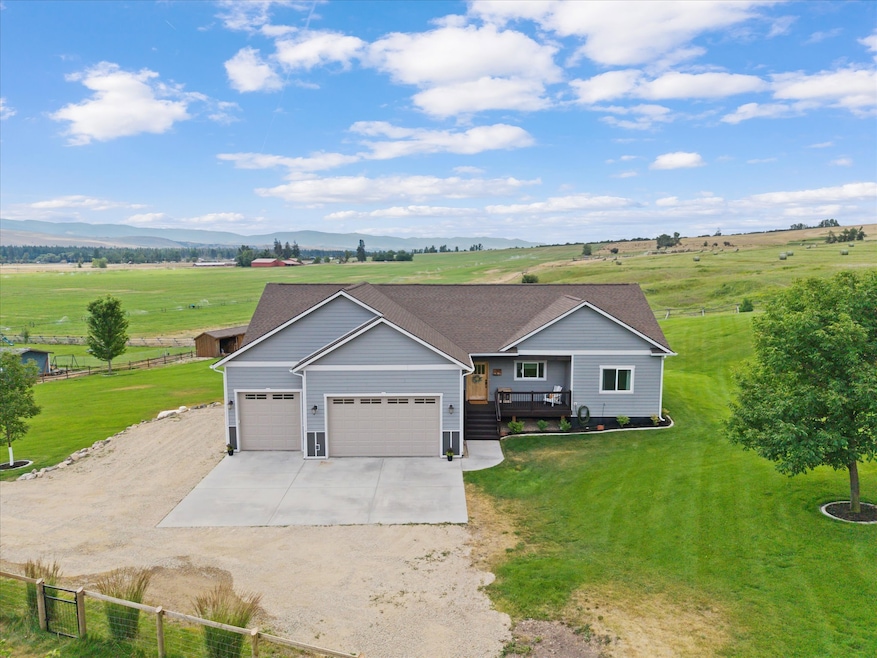
This is the one you’ve been waiting for. Set against the backdrop of the Bitterroot Mountains, this beautifully built 5 bedroom, 3 bath home offers comfortable living in a peaceful, rural setting. Constructed in 2015 with energy efficient insulated concrete forms, the home features over 3,500 square feet of thoughtfully designed space. The main level includes three bedrooms and an open concept living area filled with natural light and mountain views. Hickory hardwood floors, a gas fireplace, and spacious floor plan create a warm and inviting atmosphere. The kitchen is both functional and efficient with quartz countertops, soft-close cabinetry, stainless steel appliances, a farmhouse sink, and a large island perfect for gathering. Just off the living area, a large covered deck provides unobstructed views, ideal for watching sunsets, wildlife, and the changing weather. The spacious primary en suite features mountain views, a large walk-in closet, a beautifully tiled shower, and a deep soaking tub. Downstairs, the walkout lower level includes two additional bedrooms, a bonus room, and a large open space that works well as a family room, game room, or media space. The lower covered patio is hot tub ready and features a gas fire pit area, perfect for relaxing evenings under the stars. Additional features include a spacious heated 3 car garage, a large mudroom, radiant floor heat in all bathrooms, a lower level wood burning stove, a whole-house HRV (Heat Recovery Ventilation) system for continuous fresh air and energy efficient ventilation, indoor fire sprinklers, and a large laundry room with ample folding space. The property is beautifully landscaped with underground sprinklers and backs up to a large working ranch, offering privacy, open views, and frequent sightings of the local elk herds. This is an opportunity to own a well built home in one of the Bitterroot Valley's scenic and peaceful settings. Just 15 minutes from all the amenities of Missoula.
Last Agent to Sell the Property
Keller Williams Western MT License #RRE-RBS-LIC-81936 Listed on: 07/24/2025
Last Buyer's Agent
Engel & Völkers Western Frontier - Missoula License #RRE-RBS-LIC-99848
| Date | Type | Sale Price | Title Company |
|---|---|---|---|
| Warranty Deed | -- | Insured Title | |
| Warranty Deed | -- | Insured Titles Llc |
| Date | Status | Loan Amount | Loan Type |
|---|---|---|---|
| Open | $711,000 | New Conventional |
| Date | Event | Price | List to Sale | Price per Sq Ft |
|---|---|---|---|---|
| 11/21/2025 11/21/25 | Sold | -- | -- | -- |
| 10/03/2025 10/03/25 | Price Changed | $799,999 | -5.9% | $225 / Sq Ft |
| 09/06/2025 09/06/25 | Price Changed | $849,900 | -3.3% | $239 / Sq Ft |
| 07/24/2025 07/24/25 | For Sale | $879,000 | -- | $248 / Sq Ft |
| Year | Tax Paid | Tax Assessment Tax Assessment Total Assessment is a certain percentage of the fair market value that is determined by local assessors to be the total taxable value of land and additions on the property. | Land | Improvement |
|---|---|---|---|---|
| 2025 | $5,374 | $711,900 | $208,500 | $503,400 |
| 2024 | $6,193 | $584,300 | $108,800 | $475,500 |
| 2023 | $5,228 | $584,300 | $108,800 | $475,500 |
| 2022 | $4,758 | $441,100 | $0 | $0 |
| 2021 | $4,842 | $441,100 | $0 | $0 |
| 2020 | $4,838 | $433,200 | $0 | $0 |
| 2019 | $4,806 | $433,200 | $0 | $0 |
| 2018 | $3,730 | $392,500 | $0 | $0 |
| 2017 | $3,703 | $392,500 | $0 | $0 |
| 2016 | $2,201 | $239,070 | $0 | $0 |
| 2015 | $835 | $93,700 | $0 | $0 |
| 2014 | $940 | $57,876 | $0 | $0 |
Seller's Agent in 2025
June Murray
Keller Williams Western MT
(406) 531-0627
110 Total Sales
J
Buyer's Agent in 2025
Jennifer Bennett
Engel & Völkers Western Frontier - Missoula
(917) 748-8914
7 Total Sales
Source: Montana Regional MLS
MLS Number: 30054017
APN: 04-1975-14-3-01-30-0000
Disclaimer: Certain information contained herein is derived from information provided by parties other than Homes.com. All information provided is deemed reliable, but is not guaranteed to be accurate and should be independently verified.
![]() IDX information is provided exclusively for personal, non-commercial use, and may not be used for any purpose other than to identify prospective properties consumers may be interested in purchasing. Information is deemed reliable but not guaranteed.
IDX information is provided exclusively for personal, non-commercial use, and may not be used for any purpose other than to identify prospective properties consumers may be interested in purchasing. Information is deemed reliable but not guaranteed.
Ask me questions while you tour the home.