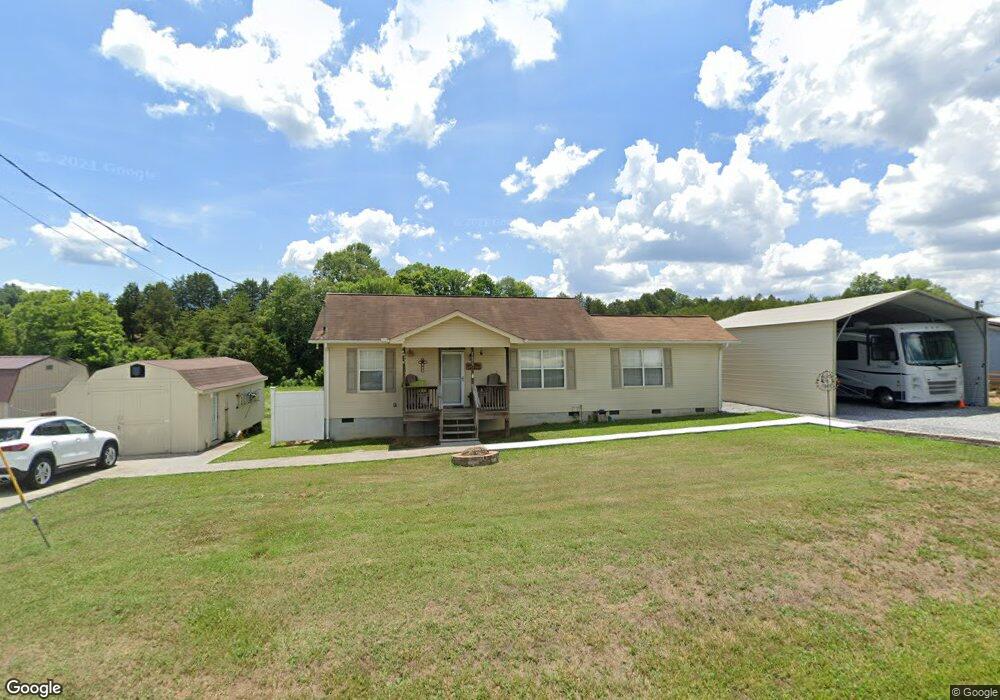
1695 Westwood Rd Mohawk, TN 37810
Estimated Value: $169,000 - $192,771
--
Bed
1
Bath
1,032
Sq Ft
$172/Sq Ft
Est. Value
About This Home
This home is located at 1695 Westwood Rd, Mohawk, TN 37810 and is currently estimated at $177,693, approximately $172 per square foot. 1695 Westwood Rd is a home located in Greene County with nearby schools including McDonald Elementary School, West Greene Middle Schools, and West Greene High School.
Ownership History
Date
Name
Owned For
Owner Type
Purchase Details
Closed on
Feb 27, 2024
Sold by
Bohms Family Charitable Trust
Bought by
Etn Properties Llc
Current Estimated Value
Purchase Details
Closed on
Apr 25, 2023
Sold by
Davis Property Group Llc
Bought by
Live Wide Charitable Trust
Purchase Details
Closed on
Jan 7, 2019
Sold by
Bohms Alan and Bohms Kelly
Bought by
Davis Property Group Llc
Purchase Details
Closed on
Jan 24, 2006
Sold by
Brewer Christa A
Bought by
Bohms Alan
Create a Home Valuation Report for This Property
The Home Valuation Report is an in-depth analysis detailing your home's value as well as a comparison with similar homes in the area
Home Values in the Area
Average Home Value in this Area
Purchase History
| Date | Buyer | Sale Price | Title Company |
|---|---|---|---|
| Etn Properties Llc | $147,600 | Tennessee Land Title | |
| Bohms Family Charitable Trust | -- | None Listed On Document | |
| Live Wide Charitable Trust | -- | None Listed On Document | |
| Davis Property Group Llc | $76,000 | Tennessee Land Title | |
| Bohms Alan | $5,000 | -- |
Source: Public Records
Tax History Compared to Growth
Tax History
| Year | Tax Paid | Tax Assessment Tax Assessment Total Assessment is a certain percentage of the fair market value that is determined by local assessors to be the total taxable value of land and additions on the property. | Land | Improvement |
|---|---|---|---|---|
| 2024 | $572 | $34,650 | $2,875 | $31,775 |
| 2023 | $717 | $34,050 | $0 | $0 |
| 2022 | $425 | $21,100 | $1,850 | $19,250 |
| 2021 | $425 | $21,100 | $1,850 | $19,250 |
| 2020 | $425 | $21,100 | $1,850 | $19,250 |
| 2019 | $425 | $21,100 | $1,850 | $19,250 |
| 2018 | $414 | $20,550 | $1,850 | $18,700 |
| 2017 | $401 | $20,300 | $1,850 | $18,450 |
| 2016 | $380 | $20,300 | $1,850 | $18,450 |
| 2015 | $380 | $20,300 | $1,850 | $18,450 |
| 2014 | $380 | $20,300 | $1,850 | $18,450 |
Source: Public Records
Map
Nearby Homes
- 1700 Westwood Rd
- 1550 Mount Hope Rd
- 1550 Mount Hope Rd Unit 2
- 1550 Mount Hope Rd Unit 1
- Tbd Copperhead Hollow Rd Unit LotWP001
- 100 Democrat Rd
- 2750 Mountain Rd
- 5945 Union Grove Rd
- LOT 2 5375 Fred Marshall Rd
- LOT 1 5375 Fred Marshall Rd
- 425 Oakwood Rd
- 1151 Oakwood Rd
- 7194 Mountain Valley Rd
- 7 W Andrew Johnson Hwy
- 7180 Mountain Valley Rd
- N/A Oakwood Rd
- 3.35 Oakwood Rd
- 4790 Fish Hatchery Rd
- 330 Oasis Rd
- 415 Stone Mountain Rd
- Lots 9&10 Westwood Rd
- 0 Lots 9&10 Westwood Rd Unit 1124641
- 1720 Westwood Rd
- 1740 Westwood Rd
- 1631 Westwood Rd
- 1660 Westwood Rd
- 0 Lot 9 & 10 Westwood Rd Unit 600434
- Lots 2 - 3 Westwood Rd
- 0 Lots 2 - 3 Westwood Rd Unit 600423
- Lots 11&12 Westwood Rd
- 0 Lots 11&12 Westwood Rd Unit 1124645
- Lot 11 & 12 Westwood Rd
- Lot #10r Westwood Rd
- Lots 9-10 Westwood Rd
- Lot 13 - 1 Westwood Rd
- Lot 11 & 1 Westwood Rd
- Lot 9 & 10 Westwood Rd
- 6 Westwood Rd
- 13 Westwood Rd
- 14 Westwood Rd