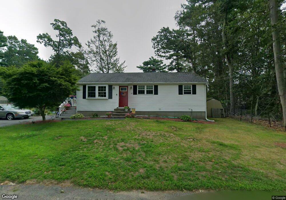
17 Azalea Rd Unit . Norton, MA 02766
Estimated Value: $464,840 - $539,000
3
Beds
1
Bath
1,200
Sq Ft
$406/Sq Ft
Est. Value
About This Home
This home is located at 17 Azalea Rd Unit ., Norton, MA 02766 and is currently estimated at $486,960, approximately $405 per square foot. 17 Azalea Rd Unit . is a home located in Bristol County with nearby schools including J.C. Solmonese Elementary School, Henri A. Yelle Elementary School, and Norton Middle School.
Ownership History
Date
Name
Owned For
Owner Type
Purchase Details
Closed on
Dec 13, 2019
Sold by
Depierro Brandon
Bought by
Laatabi Amine
Current Estimated Value
Home Financials for this Owner
Home Financials are based on the most recent Mortgage that was taken out on this home.
Original Mortgage
$333,450
Outstanding Balance
$294,559
Interest Rate
3.7%
Mortgage Type
New Conventional
Estimated Equity
$192,401
Purchase Details
Closed on
Nov 19, 2015
Sold by
Simonetti Robert R
Bought by
Depierro Brandon
Home Financials for this Owner
Home Financials are based on the most recent Mortgage that was taken out on this home.
Original Mortgage
$247,435
Interest Rate
3.75%
Mortgage Type
FHA
Purchase Details
Closed on
Oct 1, 2004
Sold by
Simonetti Robert P and Simonetti Marjorie F
Bought by
Simonetti Robert R
Home Financials for this Owner
Home Financials are based on the most recent Mortgage that was taken out on this home.
Original Mortgage
$230,000
Interest Rate
5.81%
Mortgage Type
Purchase Money Mortgage
Create a Home Valuation Report for This Property
The Home Valuation Report is an in-depth analysis detailing your home's value as well as a comparison with similar homes in the area
Home Values in the Area
Average Home Value in this Area
Purchase History
| Date | Buyer | Sale Price | Title Company |
|---|---|---|---|
| Laatabi Amine | $351,000 | None Available | |
| Depierro Brandon | $259,900 | -- | |
| Simonetti Robert R | $260,000 | -- |
Source: Public Records
Mortgage History
| Date | Status | Borrower | Loan Amount |
|---|---|---|---|
| Open | Laatabi Amine | $333,450 | |
| Previous Owner | Depierro Brandon | $247,435 | |
| Previous Owner | Simonetti Robert R | $230,000 |
Source: Public Records
Tax History Compared to Growth
Tax History
| Year | Tax Paid | Tax Assessment Tax Assessment Total Assessment is a certain percentage of the fair market value that is determined by local assessors to be the total taxable value of land and additions on the property. | Land | Improvement |
|---|---|---|---|---|
| 2025 | $50 | $386,400 | $158,500 | $227,900 |
| 2024 | $4,803 | $370,900 | $151,000 | $219,900 |
| 2023 | $4,548 | $350,100 | $142,400 | $207,700 |
| 2022 | $4,439 | $311,300 | $129,400 | $181,900 |
| 2021 | $4,101 | $274,700 | $123,300 | $151,400 |
| 2020 | $3,885 | $262,500 | $119,700 | $142,800 |
| 2019 | $3,740 | $251,000 | $115,100 | $135,900 |
| 2018 | $3,511 | $231,600 | $108,700 | $122,900 |
| 2017 | $3,420 | $222,500 | $108,700 | $113,800 |
| 2016 | $2,863 | $183,400 | $102,300 | $81,100 |
| 2015 | $2,761 | $179,400 | $100,300 | $79,100 |
| 2014 | $2,628 | $171,000 | $95,500 | $75,500 |
Source: Public Records
Map
Nearby Homes
- 18 Columbine Rd
- 15 Reservoir St Unit 44
- 21 Juniper Rd
- 39 Evergreen Rd
- 268 Reservoir St
- 15 Patten Rd
- 12 Sylvan Rd
- 0 Brook Pkwy
- 250 Mansfield Ave Unit 66
- 157 Mansfield Ave Unit 14
- 711 Ware St
- 10 Ridge Rd
- 23 Indian Rd
- 778 Ware St
- 73 Godfrey Dr
- 460 Ware St
- 442 Ware St
- 93 Mansfield Ave
- 414 Branch St
- 0 Kensington Rd