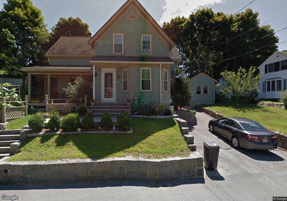
17 Gee Ave Gloucester, MA 01930
Estimated Value: $782,000 - $880,000
4
Beds
2
Baths
2,215
Sq Ft
$376/Sq Ft
Est. Value
About This Home
This home is located at 17 Gee Ave, Gloucester, MA 01930 and is currently estimated at $832,951, approximately $376 per square foot. 17 Gee Ave is a home located in Essex County with nearby schools including Beeman Memorial, Ralph B O'maley Middle School, and Gloucester High School.
Ownership History
Date
Name
Owned For
Owner Type
Purchase Details
Closed on
Jan 5, 2007
Sold by
Hsbc Bank Usa Na Tr
Bought by
Sanfilippo Ignazio and Sanfilippo Rosa
Current Estimated Value
Purchase Details
Closed on
Jun 9, 2006
Sold by
Castiello Alexander
Bought by
Hsbc Bank Usa Na Tr
Purchase Details
Closed on
May 6, 2005
Sold by
Gove Alison G and Gove Jason K
Bought by
Castiello Alexander T
Purchase Details
Closed on
Dec 15, 1994
Sold by
Fgb Realty Advisors
Bought by
Gove Jason K and Gove Alison
Purchase Details
Closed on
Jul 8, 1994
Sold by
Bolyard Carolyn
Bought by
Parsons Williame
Create a Home Valuation Report for This Property
The Home Valuation Report is an in-depth analysis detailing your home's value as well as a comparison with similar homes in the area
Purchase History
| Date | Buyer | Sale Price | Title Company |
|---|---|---|---|
| Sanfilippo Ignazio | $375,000 | -- | |
| Hsbc Bank Usa Na Tr | $379,065 | -- | |
| Castiello Alexander T | $447,000 | -- | |
| Gove Jason K | $965,000 | -- | |
| Parsons Williame | $110,729 | -- |
Source: Public Records
Mortgage History
| Date | Status | Borrower | Loan Amount |
|---|---|---|---|
| Open | Parsons Williame | $288,000 | |
| Closed | Parsons Williame | $300,000 |
Source: Public Records
Tax History
| Year | Tax Paid | Tax Assessment Tax Assessment Total Assessment is a certain percentage of the fair market value that is determined by local assessors to be the total taxable value of land and additions on the property. | Land | Improvement |
|---|---|---|---|---|
| 2025 | $7,183 | $739,000 | $170,700 | $568,300 |
| 2024 | $7,112 | $730,900 | $162,600 | $568,300 |
| 2023 | $6,788 | $641,000 | $145,200 | $495,800 |
| 2022 | $6,569 | $560,000 | $126,300 | $433,700 |
| 2021 | $6,334 | $509,200 | $114,800 | $394,400 |
| 2020 | $6,327 | $513,100 | $114,800 | $398,300 |
| 2019 | $6,010 | $473,600 | $114,800 | $358,800 |
| 2018 | $5,781 | $447,100 | $114,800 | $332,300 |
| 2017 | $5,595 | $424,200 | $109,300 | $314,900 |
| 2016 | $5,424 | $398,500 | $114,100 | $284,400 |
| 2015 | $5,136 | $376,300 | $114,100 | $262,200 |
Source: Public Records
Map
Nearby Homes
- 3 Deacon Farm Ln
- 31 Echo Ave
- 2 Breezy Point Rd
- 672 Washington St
- 13 Honeysuckle Rd
- 13 Mystic Ave
- 8 Mystic Ave
- 98 Maplewood Ave
- 6 Monroe Ct
- 167 Atlantic St
- 12 Arthur St
- 9 Cleveland Place
- 178 Atlantic St
- 40 Sargent St
- 226 Atlantic St
- 19 Trask St Unit 2
- 50 Warner St
- 113 Pleasant St
- 33 Maplewood Ave Unit 310
- 15 Mount Vernon St
Your Personal Tour Guide
Ask me questions while you tour the home.