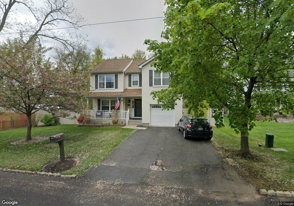
17 Maple Ave Garnerville, NY 10923
Estimated Value: $661,000 - $706,000
3
Beds
3
Baths
1,848
Sq Ft
$373/Sq Ft
Est. Value
About This Home
This home is located at 17 Maple Ave, Garnerville, NY 10923 and is currently estimated at $688,999, approximately $372 per square foot. 17 Maple Ave is a home located in Rockland County with nearby schools including Thiells Elementary School, Willow Grove Middle School, and Fieldstone Secondary School.
Ownership History
Date
Name
Owned For
Owner Type
Purchase Details
Closed on
Feb 21, 2006
Sold by
Randell Robert F and Randell Joann M
Bought by
Morris Michael J and Morris Cynthia
Current Estimated Value
Home Financials for this Owner
Home Financials are based on the most recent Mortgage that was taken out on this home.
Original Mortgage
$356,800
Outstanding Balance
$200,269
Interest Rate
6.15%
Mortgage Type
Fannie Mae Freddie Mac
Estimated Equity
$488,730
Purchase Details
Closed on
Jun 21, 2004
Sold by
Zeszutek Timothy E and Zeszutek Stephanie L
Bought by
Valente Angela
Home Financials for this Owner
Home Financials are based on the most recent Mortgage that was taken out on this home.
Original Mortgage
$205,600
Interest Rate
5.62%
Mortgage Type
Purchase Money Mortgage
Purchase Details
Closed on
Nov 5, 2001
Sold by
Davidson Patrice Mary and Bader Debra Ann
Bought by
Vannuzzi Roland and Vannuzzi Rose
Create a Home Valuation Report for This Property
The Home Valuation Report is an in-depth analysis detailing your home's value as well as a comparison with similar homes in the area
Home Values in the Area
Average Home Value in this Area
Purchase History
| Date | Buyer | Sale Price | Title Company |
|---|---|---|---|
| Morris Michael J | $446,000 | National Granite Title Ins A | |
| Valente Angela | $259,900 | -- | |
| Vannuzzi Roland | $330,000 | -- |
Source: Public Records
Mortgage History
| Date | Status | Borrower | Loan Amount |
|---|---|---|---|
| Open | Morris Michael J | $356,800 | |
| Previous Owner | Valente Angela | $205,600 | |
| Closed | Valente Angela | $38,550 |
Source: Public Records
Tax History
| Year | Tax Paid | Tax Assessment Tax Assessment Total Assessment is a certain percentage of the fair market value that is determined by local assessors to be the total taxable value of land and additions on the property. | Land | Improvement |
|---|---|---|---|---|
| 2024 | $20,209 | $304,100 | $119,000 | $185,100 |
| 2023 | $20,209 | $304,100 | $119,000 | $185,100 |
| 2022 | $2,441 | $304,100 | $119,000 | $185,100 |
| 2021 | $19,977 | $304,100 | $119,000 | $185,100 |
| 2020 | $13,599 | $304,100 | $119,000 | $185,100 |
| 2019 | $2,694 | $304,100 | $119,000 | $185,100 |
| 2018 | $13,126 | $304,100 | $119,000 | $185,100 |
| 2017 | $12,292 | $304,100 | $119,000 | $185,100 |
| 2016 | $12,314 | $304,100 | $119,000 | $185,100 |
| 2015 | -- | $304,100 | $119,000 | $185,100 |
| 2014 | -- | $304,100 | $119,000 | $185,100 |
Source: Public Records
Map
Nearby Homes
- 14 Malone Ave
- 205 Ramapo Rd Unit H
- 47 Sand St
- 28 Hewitt St
- 33 Muntz Ln
- 3 Trimble St
- 9 Oldfield Ct
- 28 Hillside Ave
- 30 Hillside Ave
- 12 Sand St
- 100 Dowd St Unit C16
- 100 Dowd St Unit D8
- 93 Main St
- 21 Bridge St
- 17 Oakley Blvd
- 78 Church St
- 20 Main St Unit 39
- 20 Main St Unit 20
- 167 Coolidge St
- 22 Ferracane Place
Your Personal Tour Guide
Ask me questions while you tour the home.