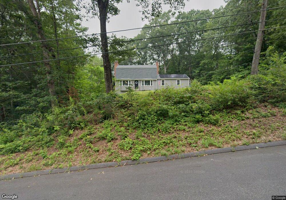
17 Maple Grove Rd Hampden, MA 01036
Estimated Value: $456,000 - $504,000
4
Beds
3
Baths
1,788
Sq Ft
$266/Sq Ft
Est. Value
About This Home
This home is located at 17 Maple Grove Rd, Hampden, MA 01036 and is currently estimated at $475,134, approximately $265 per square foot. 17 Maple Grove Rd is a home located in Hampden County with nearby schools including Minnechaug Regional High School and Wilbraham & Monson Academy.
Ownership History
Date
Name
Owned For
Owner Type
Purchase Details
Closed on
Dec 19, 2019
Sold by
Lopardo Leslie M
Bought by
Custom Homes Dev Group
Current Estimated Value
Purchase Details
Closed on
Dec 18, 2019
Sold by
Custom Homes Dev Group
Bought by
Owens Jacqueline C and Owens Grover T
Purchase Details
Closed on
Sep 18, 2007
Sold by
Lopardo Ernest
Bought by
Collins Lisbeth A and Lopardo James N
Create a Home Valuation Report for This Property
The Home Valuation Report is an in-depth analysis detailing your home's value as well as a comparison with similar homes in the area
Home Values in the Area
Average Home Value in this Area
Purchase History
| Date | Buyer | Sale Price | Title Company |
|---|---|---|---|
| Custom Homes Dev Group | $172,500 | None Available | |
| Owens Jacqueline C | $299,900 | None Available | |
| Collins Lisbeth A | -- | -- |
Source: Public Records
Tax History
| Year | Tax Paid | Tax Assessment Tax Assessment Total Assessment is a certain percentage of the fair market value that is determined by local assessors to be the total taxable value of land and additions on the property. | Land | Improvement |
|---|---|---|---|---|
| 2025 | $7,181 | $475,900 | $97,800 | $378,100 |
| 2024 | $6,886 | $439,700 | $88,100 | $351,600 |
| 2023 | $6,598 | $391,100 | $88,100 | $303,000 |
| 2022 | $6,556 | $350,200 | $88,100 | $262,100 |
| 2021 | $6,288 | $319,700 | $88,100 | $231,600 |
| 2020 | $4,830 | $239,700 | $88,100 | $151,600 |
| 2019 | $4,720 | $239,700 | $88,100 | $151,600 |
| 2018 | $4,914 | $245,700 | $88,000 | $157,700 |
| 2017 | $4,740 | $245,700 | $88,000 | $157,700 |
| 2016 | $4,693 | $242,400 | $90,600 | $151,800 |
| 2015 | $4,773 | $251,500 | $90,600 | $160,900 |
Source: Public Records
Map
Nearby Homes
- 230V Burleigh Rd
- 107 Baldwin Dr
- 85 Baldwin Dr
- 75 North Rd
- 0 Mountain Rd Unit 73267162
- 0 Mountain Rd Unit 72942534
- 24 Mcintosh Dr
- 6 Katie St
- 325 Allen St
- 237 Millbrook Dr
- 25 Winding Brook Ln
- 16 Deerfoot Dr
- 141 Tanglewood Dr
- 179 Chapin Rd
- 140 Slumber Ln
- 1070 Glendale Rd
- Lot D South Rd
- 41 Martin Farms Rd
- 241 Hampden Rd
- 175 Scantic Rd
- 21 Maple Grove Rd
- 0 Maple Grove Rd
- 66 Forest Hill Rd
- 8 Maple Grove Rd
- 25 Maple Grove Rd
- 60 Forest Hill Rd
- 11 Maple Grove Rd
- 11 Maple Grove Rd Unit 1
- 0 Springhouse Rd
- 81 Valleyview Dr
- 1 Chestnut Hill Rd
- 4 Chestnut Hill Rd
- 65 Pondview Dr
- 33 Maple Grove Rd
- 59 Pondview Dr
- 71 Pondview Dr
- 8 Springhouse Rd
- 54 Forest Hill Rd
- 75 Valleyview Dr
- 43 Pondview Dr
Your Personal Tour Guide
Ask me questions while you tour the home.