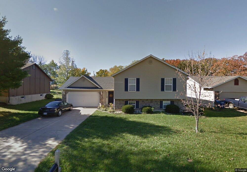
17 Pershing Cir O Fallon, MO 63366
Estimated Value: $302,000 - $318,338
4
Beds
3
Baths
1,274
Sq Ft
$243/Sq Ft
Est. Value
About This Home
This home is located at 17 Pershing Cir, O Fallon, MO 63366 and is currently estimated at $309,085, approximately $242 per square foot. 17 Pershing Cir is a home located in St. Charles County with nearby schools including Green Tree Elementary School, Wentzville South Middle School, and Timberland High School.
Ownership History
Date
Name
Owned For
Owner Type
Purchase Details
Closed on
Aug 30, 2002
Sold by
Young Patricia J
Bought by
Vargo Eugene J and Vargo Kimberly M
Current Estimated Value
Home Financials for this Owner
Home Financials are based on the most recent Mortgage that was taken out on this home.
Original Mortgage
$118,000
Interest Rate
6.33%
Purchase Details
Closed on
Jun 2, 1997
Sold by
Curtis Keith A
Bought by
Curtis Patricia J and Young Patricia J
Create a Home Valuation Report for This Property
The Home Valuation Report is an in-depth analysis detailing your home's value as well as a comparison with similar homes in the area
Home Values in the Area
Average Home Value in this Area
Purchase History
| Date | Buyer | Sale Price | Title Company |
|---|---|---|---|
| Vargo Eugene J | $125,000 | -- | |
| Curtis Patricia J | -- | -- |
Source: Public Records
Mortgage History
| Date | Status | Borrower | Loan Amount |
|---|---|---|---|
| Previous Owner | Vargo Eugene J | $118,000 |
Source: Public Records
Tax History
| Year | Tax Paid | Tax Assessment Tax Assessment Total Assessment is a certain percentage of the fair market value that is determined by local assessors to be the total taxable value of land and additions on the property. | Land | Improvement |
|---|---|---|---|---|
| 2025 | $3,294 | $56,334 | -- | -- |
| 2024 | $3,294 | $50,067 | -- | -- |
| 2023 | $3,292 | $50,067 | -- | -- |
| 2022 | $2,803 | $39,613 | $0 | $0 |
| 2021 | $2,801 | $39,613 | $0 | $0 |
| 2020 | $2,707 | $37,328 | $0 | $0 |
| 2019 | $2,513 | $37,328 | $0 | $0 |
| 2018 | $2,209 | $31,217 | $0 | $0 |
| 2017 | $2,198 | $31,217 | $0 | $0 |
| 2016 | $1,882 | $26,509 | $0 | $0 |
| 2015 | $1,850 | $26,509 | $0 | $0 |
| 2014 | $1,885 | $27,650 | $0 | $0 |
Source: Public Records
Map
Nearby Homes
- 10 Park Cir
- 7 King Cir
- 2 Royal Dr
- 827 Edgewood Dr
- 807 Briarwood Ct
- 617 Lakeview Rd
- 903 Palmer Ct Unit 3
- 22 Holloway Dr
- 1373 Sunburst Dr
- 1459 Cochise Dr
- 922 Ampere Place
- 1355 Sunny Trail Ct Unit C
- 1011 Fairways Dr
- 1015 Fairways Dr
- 219 Place
- 136 Columbia Meadows Ln
- 1 Grand Columbia @Columbia Meadows
- 1 Columbia @ Columbia Meadows
- 1 Grand Columbia II @ Columbia Meadows
- 35 Monterey Cypress Dr Unit 2
Your Personal Tour Guide
Ask me questions while you tour the home.