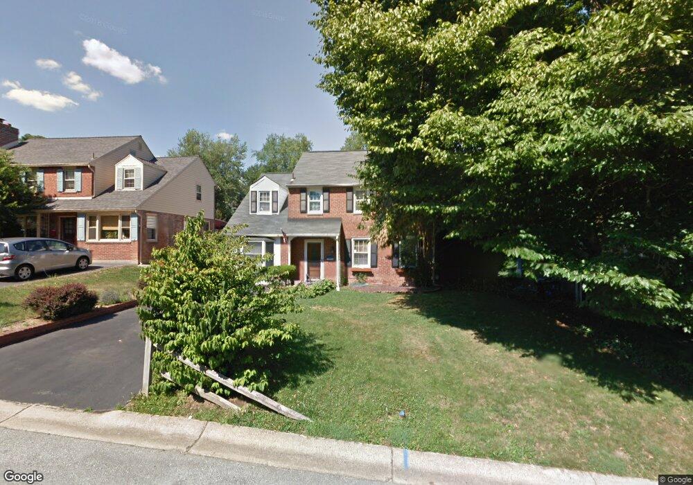
17 Stockwell Rd Wilmington, DE 19809
Estimated Value: $313,000 - $345,185
3
Beds
1
Bath
1,443
Sq Ft
$227/Sq Ft
Est. Value
About This Home
This home is located at 17 Stockwell Rd, Wilmington, DE 19809 and is currently estimated at $327,546, approximately $226 per square foot. 17 Stockwell Rd is a home located in New Castle County with nearby schools including Mount Pleasant Elementary School, Pierre S. Dupont Middle School, and Mount Pleasant High School.
Ownership History
Date
Name
Owned For
Owner Type
Purchase Details
Closed on
Nov 12, 2025
Sold by
Ritchie Kathleen P
Bought by
Ritchie Kathleen P and Ott Robert L
Current Estimated Value
Purchase Details
Closed on
Jan 14, 2005
Sold by
Billingsley Richard F and Billingsley Jane M
Bought by
Ritchie Harry P and Ritchie Kathleen P
Home Financials for this Owner
Home Financials are based on the most recent Mortgage that was taken out on this home.
Original Mortgage
$167,200
Interest Rate
5.37%
Mortgage Type
Purchase Money Mortgage
Create a Home Valuation Report for This Property
The Home Valuation Report is an in-depth analysis detailing your home's value as well as a comparison with similar homes in the area
Home Values in the Area
Average Home Value in this Area
Purchase History
| Date | Buyer | Sale Price | Title Company |
|---|---|---|---|
| Ritchie Kathleen P | -- | None Listed On Document | |
| Ritchie Harry P | $209,000 | -- |
Source: Public Records
Mortgage History
| Date | Status | Borrower | Loan Amount |
|---|---|---|---|
| Previous Owner | Ritchie Harry P | $167,200 |
Source: Public Records
Tax History Compared to Growth
Tax History
| Year | Tax Paid | Tax Assessment Tax Assessment Total Assessment is a certain percentage of the fair market value that is determined by local assessors to be the total taxable value of land and additions on the property. | Land | Improvement |
|---|---|---|---|---|
| 2024 | $2,455 | $64,500 | $9,800 | $54,700 |
| 2023 | $2,243 | $64,500 | $9,800 | $54,700 |
| 2022 | $2,282 | $64,500 | $9,800 | $54,700 |
| 2021 | $2,282 | $64,500 | $9,800 | $54,700 |
| 2020 | $2,282 | $64,500 | $9,800 | $54,700 |
| 2019 | $9 | $64,500 | $9,800 | $54,700 |
| 2018 | $2,181 | $64,500 | $9,800 | $54,700 |
| 2017 | $2,147 | $64,500 | $9,800 | $54,700 |
| 2016 | $2,146 | $64,500 | $9,800 | $54,700 |
| 2015 | $1,974 | $64,500 | $9,800 | $54,700 |
| 2014 | $1,973 | $64,500 | $9,800 | $54,700 |
Source: Public Records
Map
Nearby Homes
- 5 Blue Rock Rd
- 18 S Pennewell Dr
- 6201 Highland Ct Unit 6201
- 47 N Pennewell Dr
- 8506 Park Ct Unit 8506
- 1107 Haines Ave
- 17 S Rodney Dr
- 304 Chestnut Ave
- 302 River Rd Unit D8
- 1100 Lore Ave Unit 509
- 402 Grove Ave
- 705 Phillips Ave
- 4304 N Pine St
- 2212 Heather Ct Unit 2212
- 109 E 40th St
- 1103 Melrose Ave
- 5207 Le Parc Dr Unit 8
- 5215 Le Parc Dr Unit 2
- 5219 Le Parc Dr Unit 2
- 25 W 39th St