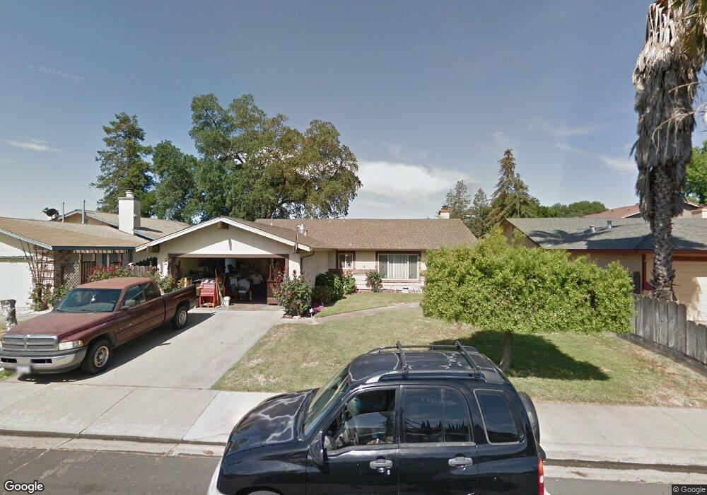
1705 Logan Ln Turlock, CA 95380
Estimated Value: $265,000 - $477,000
3
Beds
2
Baths
1,912
Sq Ft
$216/Sq Ft
Est. Value
About This Home
This home is located at 1705 Logan Ln, Turlock, CA 95380 and is currently estimated at $413,800, approximately $216 per square foot. 1705 Logan Ln is a home located in Stanislaus County with nearby schools including Walter M. Brown Elementary School, Marvin A. Dutcher Middle School, and Turlock Junior High School.
Ownership History
Date
Name
Owned For
Owner Type
Purchase Details
Closed on
Mar 15, 1999
Sold by
Navas Armando and Navas Giselle
Bought by
Tanner Stanley Jay and Tanner Linda M
Current Estimated Value
Home Financials for this Owner
Home Financials are based on the most recent Mortgage that was taken out on this home.
Original Mortgage
$99,960
Outstanding Balance
$24,151
Interest Rate
6.73%
Mortgage Type
VA
Estimated Equity
$389,649
Create a Home Valuation Report for This Property
The Home Valuation Report is an in-depth analysis detailing your home's value as well as a comparison with similar homes in the area
Purchase History
| Date | Buyer | Sale Price | Title Company |
|---|---|---|---|
| Tanner Stanley Jay | $98,000 | Fidelity National Title Co |
Source: Public Records
Mortgage History
| Date | Status | Borrower | Loan Amount |
|---|---|---|---|
| Open | Tanner Stanley Jay | $99,960 |
Source: Public Records
Tax History
| Year | Tax Paid | Tax Assessment Tax Assessment Total Assessment is a certain percentage of the fair market value that is determined by local assessors to be the total taxable value of land and additions on the property. | Land | Improvement |
|---|---|---|---|---|
| 2025 | $1,576 | $153,616 | $47,022 | $106,594 |
| 2024 | $1,545 | $150,604 | $46,100 | $104,504 |
| 2023 | $1,541 | $147,652 | $45,197 | $102,455 |
| 2022 | $1,520 | $144,758 | $44,311 | $100,447 |
| 2021 | $1,497 | $141,921 | $43,443 | $98,478 |
| 2020 | $1,485 | $140,467 | $42,998 | $97,469 |
| 2019 | $1,459 | $137,713 | $42,155 | $95,558 |
| 2018 | $1,456 | $135,014 | $41,329 | $93,685 |
| 2017 | $1,421 | $132,368 | $40,519 | $91,849 |
| 2016 | $1,325 | $129,774 | $39,725 | $90,049 |
| 2015 | $1,313 | $127,826 | $39,129 | $88,697 |
| 2014 | $1,298 | $125,323 | $38,363 | $86,960 |
Source: Public Records
Map
Nearby Homes
- 2065 Cody Ct
- 1400 N Tully Rd Unit 120
- 1400 N Tully Rd Unit 91
- 1400 N Tully Rd Unit 168
- 1114 Kay Cir
- 2400 Fulkerth Rd
- 2098 Joett Dr
- 1186 Kay Cir
- 2147 Sorrel Dr
- 2450 Fulkerth Rd
- 990 Shawnan Dr
- 2230 Aspenwood Dr
- 2091 State St
- 961 Countryside Dr
- 2470 Sea Lion Way
- 2755 N Walnut Rd Unit 114
- 2375 Oxford Ave
- 2631 Polous Dr
- 2531 Craftsman St
- 1249 Magic Sands Way
Your Personal Tour Guide
Ask me questions while you tour the home.