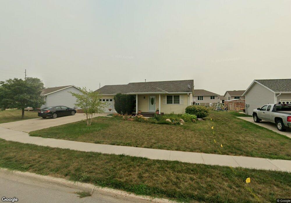
1706 High Ridge Rd Carroll, IA 51401
Estimated Value: $204,831 - $222,000
3
Beds
2
Baths
960
Sq Ft
$219/Sq Ft
Est. Value
About This Home
This home is located at 1706 High Ridge Rd, Carroll, IA 51401 and is currently estimated at $210,708, approximately $219 per square foot. 1706 High Ridge Rd is a home with nearby schools including Fairview Elementary School, Adams Elementary School, and Carroll Middle School.
Ownership History
Date
Name
Owned For
Owner Type
Purchase Details
Closed on
Sep 25, 2005
Sold by
Habitat For Humanity Of West Central Iow
Bought by
Petersen Tracy
Current Estimated Value
Home Financials for this Owner
Home Financials are based on the most recent Mortgage that was taken out on this home.
Original Mortgage
$44,500
Outstanding Balance
$24,073
Interest Rate
5.93%
Mortgage Type
Stand Alone Second
Estimated Equity
$186,635
Purchase Details
Closed on
Jun 2, 2005
Sold by
S & G Development L L C
Bought by
Habitat For Humanity West Central Iowa
Create a Home Valuation Report for This Property
The Home Valuation Report is an in-depth analysis detailing your home's value as well as a comparison with similar homes in the area
Home Values in the Area
Average Home Value in this Area
Purchase History
| Date | Buyer | Sale Price | Title Company |
|---|---|---|---|
| Petersen Tracy | $45,000 | None Available | |
| Habitat For Humanity West Central Iowa | $7,500 | None Available |
Source: Public Records
Mortgage History
| Date | Status | Borrower | Loan Amount |
|---|---|---|---|
| Open | Petersen Tracy | $44,500 |
Source: Public Records
Tax History Compared to Growth
Tax History
| Year | Tax Paid | Tax Assessment Tax Assessment Total Assessment is a certain percentage of the fair market value that is determined by local assessors to be the total taxable value of land and additions on the property. | Land | Improvement |
|---|---|---|---|---|
| 2025 | $2,082 | $194,010 | $23,890 | $170,120 |
| 2024 | $2,082 | $172,430 | $23,890 | $148,540 |
| 2023 | $2,323 | $172,430 | $23,890 | $148,540 |
| 2022 | $2,202 | $160,860 | $20,480 | $140,380 |
| 2021 | $2,202 | $160,860 | $20,480 | $140,380 |
| 2020 | $2,258 | $160,860 | $20,480 | $140,380 |
| 2019 | $2,194 | $160,860 | $20,480 | $140,380 |
| 2018 | $2,064 | $160,860 | $20,480 | $140,380 |
| 2017 | $2,064 | $152,796 | $18,254 | $134,542 |
| 2016 | $1,920 | $142,800 | $0 | $0 |
| 2015 | $1,920 | $129,970 | $0 | $0 |
| 2014 | $1,716 | $129,970 | $0 | $0 |
Source: Public Records
Map
Nearby Homes
- 746 Granada Rd
- 1620 Edgewood Dr
- 1550 Edgewood Dr
- 638 Capistrano Ave
- 265 Perch St
- 621 Alta Vista Dr
- 260 Bass St
- 222 Bass St
- 1137 High Ridge Rd
- 1601 Pike Ave
- 1068 Amy Ave
- 1102 Skyline Dr
- 1399 E 11th St
- 1401 E 11th St
- 1022 Skyline Dr
- 2340 Skyline Dr
- 1037 Bella Vista Dr
- 1408 N Adams St
- 1407 E 10th St
- 1409 E 10th St
- 1718 High Ridge Rd
- 1702 High Ridge Rd
- 1705 Oakwood Dr
- 1701 Oakwood Dr
- 1719 High Ridge Rd
- 1713 Oakwood Dr
- 815 Granada Rd
- 820 Granada Rd
- 1647 Oakwood Dr
- 1638 High Ridge Rd
- 814 Granada Rd
- 1639 Oakwood Dr
- 0 Oakwood Dr
- 1702 Oakwood Dr
- 1632 High Ridge Rd
- 808 Granada Rd
- 1648 Oakwood Dr
- 801 Granada Rd
- 1633 Oakwood Dr
- 1642 Oakwood Dr