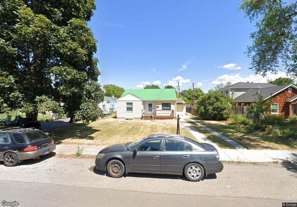
1706 S 13th St W Missoula, MT 59801
Franklin to the Fort NeighborhoodEstimated Value: $495,000 - $629,000
2
Beds
2
Baths
1,812
Sq Ft
$320/Sq Ft
Est. Value
About This Home
This home is located at 1706 S 13th St W, Missoula, MT 59801 and is currently estimated at $579,983, approximately $320 per square foot. 1706 S 13th St W is a home located in Missoula County with nearby schools including Franklin School, Porter Middle School, and Hellgate High School.
Ownership History
Date
Name
Owned For
Owner Type
Purchase Details
Closed on
Aug 13, 2025
Sold by
Temple Michael V and Balakian Erica
Bought by
Burke Anna and Burke Maurice
Current Estimated Value
Home Financials for this Owner
Home Financials are based on the most recent Mortgage that was taken out on this home.
Original Mortgage
$280,000
Outstanding Balance
$279,755
Interest Rate
6.67%
Mortgage Type
New Conventional
Estimated Equity
$300,228
Purchase Details
Closed on
Oct 4, 2022
Sold by
Stanley Deborah D
Bought by
Temple Michael V and Balakian Erica
Home Financials for this Owner
Home Financials are based on the most recent Mortgage that was taken out on this home.
Original Mortgage
$423,750
Interest Rate
5.16%
Mortgage Type
New Conventional
Purchase Details
Closed on
May 8, 2016
Sold by
Stanley Deborah D
Bought by
Stanley Deborah D and Knapp Wayna
Home Financials for this Owner
Home Financials are based on the most recent Mortgage that was taken out on this home.
Original Mortgage
$204,000
Interest Rate
3.66%
Mortgage Type
Purchase Money Mortgage
Create a Home Valuation Report for This Property
The Home Valuation Report is an in-depth analysis detailing your home's value as well as a comparison with similar homes in the area
Home Values in the Area
Average Home Value in this Area
Purchase History
| Date | Buyer | Sale Price | Title Company |
|---|---|---|---|
| Burke Anna | -- | Flying S Title And Escrow | |
| Temple Michael V | -- | First American Title | |
| Stanley Deborah D | -- | None Available |
Source: Public Records
Mortgage History
| Date | Status | Borrower | Loan Amount |
|---|---|---|---|
| Open | Burke Anna | $280,000 | |
| Previous Owner | Temple Michael V | $423,750 | |
| Previous Owner | Stanley Deborah D | $204,000 |
Source: Public Records
Tax History Compared to Growth
Tax History
| Year | Tax Paid | Tax Assessment Tax Assessment Total Assessment is a certain percentage of the fair market value that is determined by local assessors to be the total taxable value of land and additions on the property. | Land | Improvement |
|---|---|---|---|---|
| 2025 | $6,228 | $596,710 | $208,650 | $388,060 |
| 2024 | $5,967 | $490,370 | $160,550 | $329,820 |
| 2023 | $5,759 | $490,370 | $160,550 | $329,820 |
| 2022 | $4,696 | $346,755 | $0 | $0 |
| 2021 | $4,212 | $346,755 | $0 | $0 |
| 2020 | $4,091 | $311,885 | $0 | $0 |
| 2019 | $4,065 | $311,885 | $0 | $0 |
| 2018 | $3,590 | $267,770 | $0 | $0 |
| 2017 | $3,528 | $267,770 | $0 | $0 |
| 2016 | $3,231 | $256,110 | $0 | $0 |
| 2015 | $2,083 | $178,200 | $0 | $0 |
| 2014 | $1,921 | $92,591 | $0 | $0 |
Source: Public Records
Map
Nearby Homes
- 1619 S 13th St W
- 1638 S 14th St W
- 1641 S 14th St W
- 1550 S 13th St W Unit A
- NHN S 13th St W Unit Lot 9A
- 1635 S 8th St W
- 1815 S 8th St W
- 2045 S 13th St W
- 1940 Strand Ave
- 229 Knowles St
- TBD Tbd
- 2115 Mount Ave Unit B
- 2124 S 14th St W
- 920 S Johnson St
- 1105 Stephens Ave Unit 1
- 1105 Stephens Ave Unit 2
- 1936 S 7th St W
- 2216 S 12th St W
- 2214 S 12th St W
- 2220 S 13th St W
- 1726 S 13th St W
- 1700 S 13th St W
- 1732 S 13th St W
- 1403 S Catlin St
- 1403 Catlin St
- 1719 S 12th St W
- 1727 S 12th St W
- 1125 S Catlin St Unit A,B,C
- 1125 S Catlin St Unit C
- 1125 S Catlin St Unit B
- 1125 S Catlin St Unit A
- 1125 S Catlin St
- 1701 S 12th St W
- 1740 S 13th St W
- 1743 S 12th St W
- 1739 S 12th St W
- 1717 S 13th St W
- 1434 S Catlin St
- 1703 S 13th St W
- 1711 S 13th St W