Estimated Value: $205,529 - $248,000
4
Beds
1
Bath
1,938
Sq Ft
$115/Sq Ft
Est. Value
About This Home
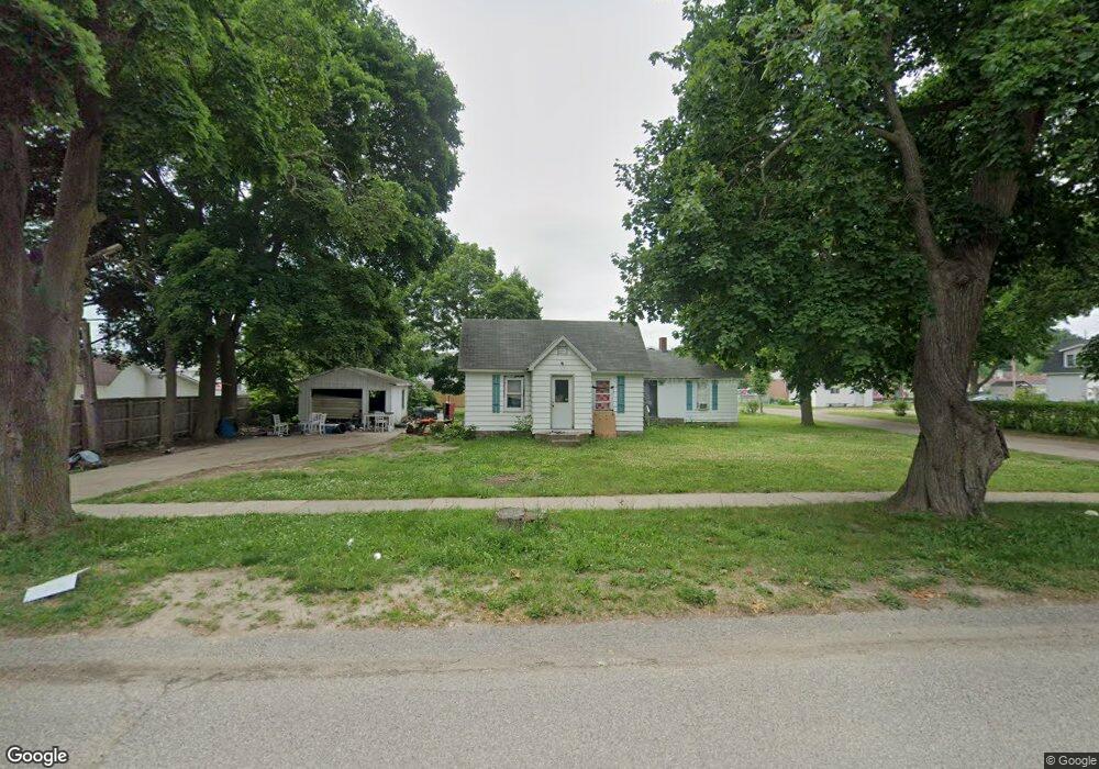
This home is located at 171 S Lake St, Grant, MI 49327 and is currently estimated at $223,632, approximately $115 per square foot. 171 S Lake St is a home located in Newaygo County with nearby schools including Grant Elementary School, Grant Primary Center, and Grant Middle School.
Ownership History
Date
Name
Owned For
Owner Type
Purchase Details
Closed on
Aug 16, 2011
Sold by
Newaygo County Treasurer
Bought by
Tms Associates
Current Estimated Value
Purchase Details
Closed on
May 30, 2003
Sold by
Secretary Of Housing & Urban Devel.
Bought by
Simon Tony Scott Et Al Lisa Clark
Purchase Details
Closed on
Dec 27, 2001
Sold by
Chase Manhattan Mtg Corp
Bought by
Secretary Of Housing
Purchase Details
Closed on
Dec 8, 2000
Sold by
Bennett Lisa
Bought by
Simon Tony Scott
Purchase Details
Closed on
Mar 10, 2000
Sold by
Hanes Melissa L
Bought by
Gill Jeryl L
Purchase Details
Closed on
Apr 21, 1999
Sold by
Watkins Virgil Lee
Bought by
Hanes Mellissa Lynn
Create a Home Valuation Report for This Property
The Home Valuation Report is an in-depth analysis detailing your home's value as well as a comparison with similar homes in the area
Home Values in the Area
Average Home Value in this Area
Purchase History
| Date | Buyer | Sale Price | Title Company |
|---|---|---|---|
| Tms Associates | $14,300 | -- | |
| Simon Tony Scott Et Al Lisa Clark | $51,600 | -- | |
| Secretary Of Housing | -- | -- | |
| Simon Tony Scott | -- | -- | |
| Gill Jeryl L | $79,900 | -- | |
| Hanes Mellissa Lynn | $45,000 | -- |
Source: Public Records
Tax History Compared to Growth
Tax History
| Year | Tax Paid | Tax Assessment Tax Assessment Total Assessment is a certain percentage of the fair market value that is determined by local assessors to be the total taxable value of land and additions on the property. | Land | Improvement |
|---|---|---|---|---|
| 2025 | $2,043 | $78,000 | $0 | $0 |
| 2024 | $10 | $68,700 | $0 | $0 |
| 2023 | $936 | $68,200 | $0 | $0 |
| 2022 | $1,870 | $56,800 | $0 | $0 |
| 2021 | $1,839 | $50,500 | $0 | $0 |
| 2020 | $1,791 | $50,000 | $0 | $0 |
| 2019 | $1,751 | $36,300 | $0 | $0 |
| 2018 | $1,733 | $30,800 | $0 | $0 |
| 2017 | $1,666 | $30,300 | $0 | $0 |
| 2016 | $1,653 | $29,300 | $0 | $0 |
| 2015 | -- | $27,000 | $0 | $0 |
| 2014 | -- | $28,200 | $0 | $0 |
Source: Public Records
Map
Nearby Homes
- 10201 Mason Dr
- 151 & 153 Clark St
- 185 E Commerce St
- 122 Lincoln St
- 86 W State Rd
- Lot 19 S Elder Ave
- 12536 S Mason Dr
- 12017 Mcclelland Ave
- 2119 W 116th St
- 2159 W 116th St
- 12285 Walnut Ave
- 953 E 136th St
- 14074 S Elder Ave
- 2308 W 112th St
- 14186 S Mocking Bird Ln
- 17474 Connor Cir
- 10616 S Walnut Rd
- 10010 Bittersweet Ave
- 9500 S Annie Ln
- 9425 S Benjamin Dr
- 147 S Lake St
- 172 S Lake St
- 166 S Lake St
- 140 S Maple St
- 133 S Lake St
- 87 Commerce
- 218 S Maple St
- 132 S Maple St
- 0 W Lone Pine Path Unit 4921590
- 0 W Lone Pine Path Unit 213050214
- 161 S Maple St
- 123 S Lake St
- 84 E Commerce St
- 84 Commerce
- 122 S Lake St
- 80 Brink
- 116 S Lake St
- 109 S Lake St
- 230 S Maple St
- 91 Commerce