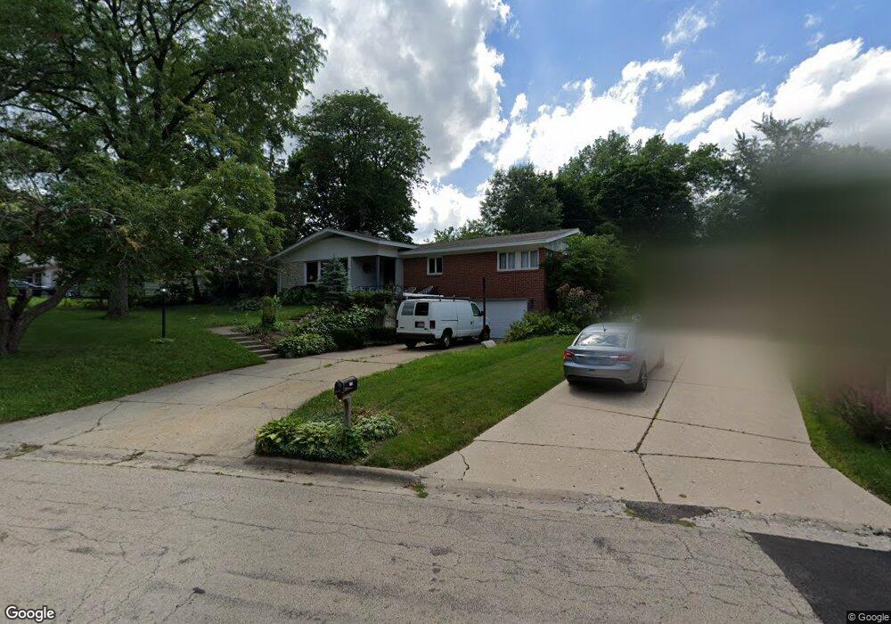
1710 Council Crest Dr Rockford, IL 61107
Estimated Value: $191,000 - $225,000
--
Bed
--
Bath
1,596
Sq Ft
$133/Sq Ft
Est. Value
About This Home
This home is located at 1710 Council Crest Dr, Rockford, IL 61107 and is currently estimated at $211,534, approximately $132 per square foot. 1710 Council Crest Dr is a home located in Winnebago County with nearby schools including Clifford P. Carlson Elementary School, Eisenhower Middle School, and Guilford High School.
Ownership History
Date
Name
Owned For
Owner Type
Purchase Details
Closed on
Nov 19, 2024
Sold by
Mesch Keith and Avila Tiffany
Bought by
Avila Tiffany
Current Estimated Value
Purchase Details
Closed on
Apr 26, 2024
Sold by
Grossner Julie
Bought by
Terry Ross Wilhelm
Purchase Details
Closed on
May 7, 2018
Sold by
Julie Gorssner
Bought by
Grossner Julie
Create a Home Valuation Report for This Property
The Home Valuation Report is an in-depth analysis detailing your home's value as well as a comparison with similar homes in the area
Home Values in the Area
Average Home Value in this Area
Purchase History
| Date | Buyer | Sale Price | Title Company |
|---|---|---|---|
| Avila Tiffany | -- | None Listed On Document | |
| Avila Tiffany | -- | None Listed On Document | |
| Terry Ross Wilhelm | -- | None Listed On Document | |
| Grossner Julie | -- | None Listed On Document |
Source: Public Records
Tax History Compared to Growth
Tax History
| Year | Tax Paid | Tax Assessment Tax Assessment Total Assessment is a certain percentage of the fair market value that is determined by local assessors to be the total taxable value of land and additions on the property. | Land | Improvement |
|---|---|---|---|---|
| 2024 | $5,579 | $58,877 | $11,837 | $47,040 |
| 2023 | $3,766 | $36,269 | $10,436 | $25,833 |
| 2022 | $5,301 | $46,401 | $9,328 | $37,073 |
| 2021 | $5,215 | $42,546 | $8,553 | $33,993 |
| 2020 | $3,007 | $23,384 | $8,086 | $15,298 |
| 2019 | $4,332 | $38,336 | $7,707 | $30,629 |
| 2018 | $4,589 | $36,128 | $7,263 | $28,865 |
| 2017 | $5,173 | $34,866 | $6,951 | $27,915 |
| 2016 | $4,262 | $34,213 | $6,821 | $27,392 |
| 2015 | $4,023 | $32,301 | $6,821 | $25,480 |
| 2014 | $4,305 | $34,590 | $8,503 | $26,087 |
Source: Public Records
Map
Nearby Homes
- 2920 Buckingham Dr
- 1928 Bradley Rd
- 1419 Roncevalles Ave
- 3606 Pinecrest Rd
- 1104 Winthrop Ln
- 2716 Spring Creek Rd
- 4000 Crestview Dr
- 2014 Glenview Rd
- 2020 Glenview Rd
- 3610 Arden Ct
- 3820 Brendenwood Rd
- 2520 Oakridge Ln
- 2020 Valley Rd
- 909 Woodlane Ave
- 4012 Highcrest Rd
- 1940 Hawthorne Dr
- 3505 Brookview Rd
- 3838 Abbotsford Rd
- 1716 Council Crest Dr
- 3124 Highcrest Rd
- 3120 Highcrest Rd
- 1717 Council Crest Dr
- 3130 Highcrest Rd
- 1711 Bradley Rd
- 1717 Bradley Rd
- 1724 Council Crest Dr
- 3112 Highcrest Rd
- 1711 Council Crest Dr
- 1723 Council Crest Dr
- 1721 Bradley Rd
- 1703 Council Crest Dr
- 1714 Stratford Ln
- 1804 Council Crest Dr
- 1727 Bradley Rd
- 1622 Winthrop Ln
- 1708 Stratford Ln
- 3103 Highcrest Rd
- 1702 Stratford Ln