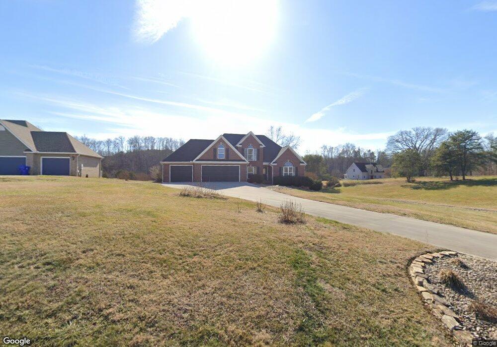
1711 Sams Dr Dandridge, TN 37725
Estimated Value: $583,000 - $737,652
3
Beds
3
Baths
2,904
Sq Ft
$231/Sq Ft
Est. Value
About This Home
This home is located at 1711 Sams Dr, Dandridge, TN 37725 and is currently estimated at $670,163, approximately $230 per square foot. 1711 Sams Dr is a home located in Jefferson County.
Ownership History
Date
Name
Owned For
Owner Type
Purchase Details
Closed on
Aug 18, 2023
Sold by
Mitchell Eldon and Mitchell Pamela K
Bought by
Bellerose Developments Llc
Current Estimated Value
Purchase Details
Closed on
Dec 27, 2005
Sold by
Rose Stephen M
Bought by
Eldon Mitchell
Home Financials for this Owner
Home Financials are based on the most recent Mortgage that was taken out on this home.
Original Mortgage
$100,000
Interest Rate
6.28%
Purchase Details
Closed on
Jul 26, 1996
Sold by
Franklin Ben Trustees
Bought by
Stephen Rose
Create a Home Valuation Report for This Property
The Home Valuation Report is an in-depth analysis detailing your home's value as well as a comparison with similar homes in the area
Home Values in the Area
Average Home Value in this Area
Purchase History
| Date | Buyer | Sale Price | Title Company |
|---|---|---|---|
| Bellerose Developments Llc | $597,000 | Jefferson Title | |
| Eldon Mitchell | $510,000 | -- | |
| Stephen Rose | $48,000 | -- |
Source: Public Records
Mortgage History
| Date | Status | Borrower | Loan Amount |
|---|---|---|---|
| Previous Owner | Stephen Rose | $100,000 |
Source: Public Records
Tax History Compared to Growth
Tax History
| Year | Tax Paid | Tax Assessment Tax Assessment Total Assessment is a certain percentage of the fair market value that is determined by local assessors to be the total taxable value of land and additions on the property. | Land | Improvement |
|---|---|---|---|---|
| 2025 | $2,455 | $171,700 | $43,250 | $128,450 |
| 2023 | $2,009 | $87,350 | $0 | $0 |
| 2022 | $1,913 | $87,350 | $18,325 | $69,025 |
| 2021 | $1,913 | $87,350 | $18,325 | $69,025 |
| 2020 | $1,913 | $87,350 | $18,325 | $69,025 |
| 2019 | $1,913 | $87,350 | $18,325 | $69,025 |
| 2018 | $1,868 | $79,475 | $18,325 | $61,150 |
| 2017 | $1,868 | $79,475 | $18,325 | $61,150 |
| 2016 | $1,868 | $79,475 | $18,325 | $61,150 |
| 2015 | $1,868 | $79,475 | $18,325 | $61,150 |
| 2014 | $1,868 | $79,475 | $18,325 | $61,150 |
Source: Public Records
Map
Nearby Homes
- 1920 Mountain Lake Dr
- 1710 Ferry Hill Rd
- Lots 1&2 Ferry Hill Rd
- 1635 Sams Dr
- 1614 Sams Dr
- 312 Economy Cir
- 1737 Doc Terry Rd
- 1045 Southwind Cir
- 344 Economy Cir
- 621 Highway 139
- 1018 Southwind Cir
- 428 River Bend Dr
- 136 Crosslake Ln
- 1928 Bouldercrest Dr
- 450 Riverbend Dr
- 417 Little Cove Dr
- 1988 Lakebrook Cir
- 1991 Lakebrook Cir
- 1806 Pheasant Crossing Dr
- 626 Briarwood Dr
- 1721 Sams Dr
- 377 Terry Point Rd
- 1724 Sams Dr
- 381 Terry Point Rd
- 373 Terry Point Rd
- 387 Terry Point Rd
- 1727 Sams Dr
- 1731 Sams Dr
- 1734 Sams Dr
- 1733 Sams Dr
- 1733 Sams Dr Unit S/D - WILD GOOSE COV
- 1681 Sams Dr
- 382 Terry Point Rd
- 388 Terry Point Rd
- 369 Terry Point Rd
- 1740 Sams Dr
- 370 Terry Point Rd
- 394 Terry Point Rd
- 1667 Sams Dr
- 1743 Sams Dr